Platforms: iPhone, iPad, iPod Touch, Apple iPhone OS
Categories: Travel & Navigation
Upload date: 11 Apr 12
Developer: Visual IT
License: Commercial
Price: 2.99 $
Downloads: 32
London Bus by Zuti - The new Zuti London Bus map has finally arrived, making it easy to travel by bus anywhere in central London. This clear and colourful map covers a detailed street level area of 6 miles by 4 miles and includes over 1300 bus stops and 189 bus routes.
All day and night bus routes running through the central area are covered in full and this means routes run to Wembley, Edgware, Edmonton, Ilford, Woolwich, Croydon and Richmond in the day and to Uxbridge, Harrow Weald, Stanmore, Kingston, Edgware, Barnet, Heathrow Airport, Enfield, Waltham Cross, Hainault, Romford, Erith (Bexleyheath), Foots Cray, St. Paul's Cray, New Addington, Old Coulsdon, and Sutton at night.
The map and routing information is stored completely on the device and needs no internet connection, making it ideal for iPod Touch and iPhone users visiting the UK who want to avoid paying roaming charges.
MAP
The map is hand drawn by Visual IT and provides a unique geographically based view of the city with many places of interest drawn directly on the background so you can easily get your bearings when traveling in and around the city. You can also use your inbuilt GPS (can also work with iPod Touch devices) to accurately locate and track yourself within the city centre and see the nearest transportation stop and distance to it. This is the only pubic transportation route planner with this ability.
Tap on the map for location information, use the inbuilt search feature or choose from a list of locations. Places of interest, museums, hotels, parks, restaurant, shops, hospitals, streets, etc, are also included. The route planner will automatically suggest the nearest station to any place of interest you select.
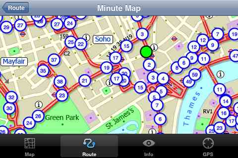
MINUTE MAP
Another unique feature of this product is our “Minute Map” option which allows you to see the travel times from a start point to all other locations on the map. This can be very useful and is not available in any other product on the market.
NO INTERNET CONNECTION REQUIRED
The map and routing does not require an internet connection and you will not be charged data connection fees. This also means the application runs successfully underground and on an iPod Touch. The only feature that requires an internet data connection is the “Live Info” which is optional and if used only requires a small amount of data.
ROUTING
Does not require an internet connection and will always be available to display a clear and detailed view of the city bus transport system, plus list and animate the optimum route for your journey. Provides the fastest route calculations of any mobile routing application (virtually instantaneous) using actual published journey times with the ability to select the quickest route or the route with the least changes.
What's New in This Release:
· Much larger and more detailed map.
· Map now includes London 2012 Olympic venues.
· Lots of minor improvements.
Like it? Share with your friends!
If you got an error while installing Themes, Software or Games, please, read FAQ.
Supported operating systems:
Apple iOS 10.x (iPad), Apple iOS 10.x (iPhone), Apple iOS 11.x (iPad), Apple iOS 12.x (iPad), Apple iOS 12.x (iPhone), Apple iOS 4.0.x (iPhone), Apple iOS 4.0.x (iPod Touch), Apple iOS 4.2.x (iPad), Apple iOS 4.2.x (iPhone), Apple iOS 4.2.x (iPod Touch), Apple iOS 4.3.x (iPad), Apple iOS 4.3.x (iPhone), Apple iOS 4.3.x (iPod Touch), Apple iOS 5.0 (iPad), Apple iOS 5.0 (iPhone), Apple iOS 5.0 (iPod Touch), Apple iOS 6.0 (iPad), Apple iOS 6.0 (iPhone), Apple iOS 6.0 (iPod Touch), Apple iOS 7.0 (iPad), Apple iOS 7.0 (iPhone), Apple iOS 7.0 (iPod Touch), Apple iOS 8.x (iPad), Apple iOS 8.x (iPhone), Apple iOS 8.x (iPod Touch), Apple iOS 9.x (iPad), Apple iOS 9.x (iPhone), Apple iOS 9.x (iPod Touch), Apple iPhone OS 3.1.x, Apple iPhone OS 3.1.x (iPod Touch), Apple iPhone OS 3.2.x (iPad)
Similar Software:
Boston Subway by Zuti Boston Subway by Zuti - The new Boston Subway map makes it easy to travel in and around the city using the MBTA Subway, MBTA Commuter Rail, MBTA Boats, and Massport shuttle buses
Vienna Metro for iPad by Zuti Vienna Metro for iPad by Zuti - The new Zuti Vienna Metro map makes it easy to travel in and around the city using the Metro (U-Bahn), Suburban Rail (S-Bahn) or Tram (Stragenbahn) systems
TransitGuru Nevada RTC TransitGuru Nevada RTC - The only transit app that combines with offline schedule, system maps, alarm to wake you up when arrival, and integration with Yelp and Map.
This application covers the Regional Transportation Commission of Southern Nevada (RTC) bus for Las Vegas, Nevada
TransitM&S New Orleans TransitM&S New Orleans - TransitM&S is an easy-to-use transit application that provides bus info for the metro New Orleans' Regional Transit Authority (RTA).
The app is designed for offline use. It is ideal for iPod Touch users. Even for iPhone users, it is designed to save money because AT&T no longer offers the unlimited data plan
Chicago Metro for iPad by Zuti Chicago Metro for iPad by Zuti - Chicago Metro map makes it easy to travel in and around the city using the CTA rapid transport system, the commuter services of Metrarail, Northern Indiana Commuter Transportation District and also the Water Taxi services
Rome Metro for iPad by Zuti Rome Metro for iPad by Zuti - The Zuti Rome Metro application is a superb geographically based map and route planner for the Metro, Tram, Urban and Regional rail systems. Unlike old fashioned schematic style maps this product contains a geographically accurate central area showing major streets, parks and places of interest etc, allowing the user to easily get their bearings
Barcelona Metro 10 for iPad Barcelona Metro 10 - This Zuti application contains a visually unique map of the Barcelona transport system and a superb animated journey planner to help you get around the TMB (Transports Metropolitan de Barcelona), FGC (Ferrocarrils de la Generalitat de Catalunya) Metro and Tram services
iBART Live iBART Live From the makers of the acclaimed iBART, iBART Live is an intelligent transit application for Bay Area Rapid Transit. It is essential to all BART riders — from the occasional to the daily, the tourist to the commuter
London Tube by Zuti London Tube by Zuti - "London Tube 10" is a superb geographically based map and route planner for the London Underground, Overground, Docklands Light Railway (DLR), Croydon Tramlink and London Airport Express services. This is one in a worldwide series of Zuti maps from Visual IT who have been producing public transportation maps for mobile devices for many years
TransitM&S Phoenix TransitM&S Phoenix - TransitM&S is an easy-to-use transit application that provides bus info for Valley Metro Transit at greater Phoenix metro area.
The app is designed for offline use. It is ideal for iPod Touch users. Even for iPhone users, it is designed to save money because AT&T no longer offers the unlimited data plan
Other Software by developer «Visual IT»:
London Congestion Charge Map (Palm OS) London Congestion Charge Map (Palm OS) - This map package is an essential addition to your Tube 2 maps if you drive in or around central London.
This reference map gives you a clear view of the area now covered by the congestion charge system, complete with a quick find utility to help you find any major road or street in and around the area
Tube 2 Engine (UIQ) Tube 2 Engine (UIQ) - Transform your phone into a fully scrollable detailed map of one of the worlds subway or metro systems.
See your journeys come alive with a superb animated display.
Save hours by automatically having the quickest routes to hand, with all the details you need including line changes, platform directions and accurate journey times
Tube 2 New York Geo (Palm OS) Tube 2 New York Geo (Palm OS) - This superb map package for Tube 2 is the ideal map for anyone who needs to get around New York City using the MTA subway system and would like to know just exactly where they are.
The map geographically accurately locates all of Manhattans central stations, overlaid onto a street map
London Mini A-Z for iPad London Mini A-Z for iPad - This clear and colourful high quality map is a digital rendition of the famous "London A-Z Mini Atlas" and covers an area from West Hendon in the North West to Grove Park in the South East. Add this application to you iPad and you will have instant access to all 352 pages of the London Mini A-Z printed map
Tube 2 Seoul (UIQ) Tube 2 Seoul (UIQ) - This map package for Tube 2 consists of a fully scrollable detailed map of the Seoul Metropolitan Subway system.
Plan journeys on this system, list details of the quickest routes and see a superb animated display of your journey tracking around the system map
Tube 2 New York City Pro (UIQ) Tube 2 New York City Pro (UIQ) - This map package for Tube 2 consists of a fully scrollable detailed map of the New York City MTA subway system and linked high quality street maps of Manhattan. Also included are additional reference maps of the rail systems surrounding NYC
Tube 2 Paris (UIQ3) Tube 2 Paris (UIQ3) - This map package for Tube 2 consists of a fully scrollable detailed map of the Paris metro and RER system.
Plan journeys on this system, list details of the quickest routes and see a superb animated display of your journey tracking around the system map
Tyne & Wear Metro by Zuti Tyne & Wear Metro by Zuti - The new Tyne & Wear Metro map makes it easy to travel in and around the city using the Nexus Metro system. Unlike old fashioned schematic style maps this product contains a geographically accurate central area showing major streets, parks and places of interest etc, allowing the user to easily get their bearings
Tube New York City (Series 60) Tube New York City (Series 60) - Our highly acclaimed Tube application that guides you around the complex MTA subway system of New York City is now available for your Series 60 Symbian powered phone. An essential addition to your phone for locals and tourists alike.
· A detailed clear colour map of the transport system fully scrollable
Tube 2 Madrid Pro (Palm OS) Tube 2 Madrid Pro (Palm OS) - This map package for Tube 2 consists of a fully scrollable detailed map of the Madrid metro system and linked street maps of central Madrid.
Plan journeys on the metro system, list details of the quickest routes and see a superb animated display of your journey tracking around the system map


")
")
")

")
")
")

")
")