Platforms: iPhone, iPad, iPod Touch, Apple iPhone OS
Categories: Travel & Navigation
Upload date: 12 Jul 13
Developer: Visual IT
License: Commercial
Price: 2.99 $
Downloads: 23
Tyne & Wear Metro by Zuti - The new Tyne & Wear Metro map makes it easy to travel in and around the city using the Nexus Metro system. Unlike old fashioned schematic style maps this product contains a geographically accurate central area showing major streets, parks and places of interest etc, allowing the user to easily get their bearings.
MAP
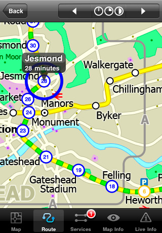
The map is hand drawn by Visual IT and provides a unique geographically based view of Tyne & Wear with many places of interest drawn directly on the background so you can easily get your bearings when traveling around the city. You can also use your inbuilt GPS to accurately locate and track yourself within the city centre and see the nearest transportation stop and distance to it. This is the only public transportation route planner with this ability.
Tap on the map for location information, use the inbuilt search feature or choose from a list of locations. Places of interest, museums, hotels, parks, restaurant, shops, hospitals, streets, etc, are also included. The route planner will automatically suggest the nearest station to any place of interest you select.
MINUTE MAP
Another great feature is the “Minute Map” option which allows you to see the travel times from a start point to all other locations on the map. This is a unique way to view the topology of a city and gauge traveling times.
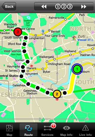
ROUTING
The application does not require an internet connection and will always be available to display a clear and detailed view of the city transport systems, plus list and animate the optimum route for your journey. This product provides the fastest route calculations of any mobile routing application (virtually instantaneous) using actual published journey times with the ability to select the quickest route or the route with the least changes.
LIVE INFO
When an internet connection is available, optional "Live Information" on the current state of the transport services can be viewed, allowing you to plan your journeys in advance and avoid any potential delays.
· Full offline map and routing, no internet connection required.
· Colourful clear custom drawn geographically accurate mapping.
· Animates the route and allows tracking of the journey using GPS
· Instantly see the route of any transport service drawn on the map.
· Save and recall favourite and recent journeys.
· Take me home feature.
· Unique "Minute Map" feature allows quick view of all journey times from a start location.
· Services can be turned on or off, routing round problems.
· Works on iPhone or iPod and in landscape or portrait mode.
· GPS location and tracking.
· Streets, Places of interest etc built into the application.
· Access to live service information.
What's New in This Release:
· New updated map
· New features
· Improved user interface
Like it? Share with your friends!
If you got an error while installing Themes, Software or Games, please, read FAQ.
Supported operating systems:
Apple iOS 10.x (iPad), Apple iOS 10.x (iPhone), Apple iOS 11.x (iPad), Apple iOS 12.x (iPad), Apple iOS 12.x (iPhone), Apple iOS 4.0.x (iPhone), Apple iOS 4.0.x (iPod Touch), Apple iOS 4.2.x (iPad), Apple iOS 4.2.x (iPhone), Apple iOS 4.2.x (iPod Touch), Apple iOS 4.3.x (iPad), Apple iOS 4.3.x (iPhone), Apple iOS 4.3.x (iPod Touch), Apple iOS 5.0 (iPad), Apple iOS 5.0 (iPhone), Apple iOS 5.0 (iPod Touch), Apple iOS 6.0 (iPad), Apple iOS 6.0 (iPhone), Apple iOS 6.0 (iPod Touch), Apple iOS 7.0 (iPad), Apple iOS 7.0 (iPhone), Apple iOS 7.0 (iPod Touch), Apple iOS 8.x (iPad), Apple iOS 8.x (iPhone), Apple iOS 8.x (iPod Touch), Apple iOS 9.x (iPad), Apple iOS 9.x (iPhone), Apple iOS 9.x (iPod Touch), Apple iPhone OS 3.1.x, Apple iPhone OS 3.1.x (iPod Touch), Apple iPhone OS 3.2.x (iPad)
Similar Software:
Weekend Trips Near San Antonio Weekend Trips Near San Antonio - GPSmyCity.com's day trips application is a powerful tool for planning your weekend getaways. With a well researched list of weekend getaway spots around the city you live in and the powerful navigation features built-in, you will never be bored on a weekend.
This app works on iPhone, iPad and iPod Touch
Tube Vienna (iPhone) Tube Vienna (iPhone) is a superb interactive guide to the Vienna Metro (U-Bahn) and Vienna Tram (StrassenBahn) systems.
With no need for an internet connection Tube Vienna will always be available to display a clear and detailed view of the city transport systems, plus list and animate the optimum route for all your journeys
Lancaster London (iPhone) Lancaster London (iPhone) - There's one thing that guests at Lancaster London always seem to agree on - the views are breathtaking. With Hyde Park, the largest of the Royal Parks, directly to the south, and vistas east to the City of London, we have arguably the best views in London
Vienna Metro 10 Vienna Metro 10 - This Zuti application contains a visually unique map of Vienna's transport systems and a superb animated journey planner to help you get around the Metro (U-Bahn), Suburban Rail (S-Bahn) and Tram (Stragenbahn)
Lonely Planet Lyon City Guide Lonely Planet Lyon City Guide - Browse guidebook chapters, discover neighbourhoods & plan your itinerary.
· Offline maps
· Location-based navigation
· Hundreds of points of interest
· professional image gallery
· Personalised favourites
· Editorial content
What's New in This Release:
· Missing content bug fixed
Pubs on 'n around royal mile Pubs on 'n around royal mile - GPSmyCity.com's directory guide is a powerful tool for planning your visit to a new city. Each directory guide comes with a well researched and detailed list of related attractions; such as museums, night clubs, restaurants, cafes, shops, etc. The powerful built-in navigation features provide travel directions to each venue
London Tube by Zuti London Tube by Zuti - "London Tube 10" is a superb geographically based map and route planner for the London Underground, Overground, Docklands Light Railway (DLR), Croydon Tramlink and London Airport Express services. This is one in a worldwide series of Zuti maps from Visual IT who have been producing public transportation maps for mobile devices for many years
Vancouver Family Fun Vancouver Family Fun - Looking for the perfect family outing in Vancouver? Need a Vancouver restaurant that will feed both you and your kids? Not sure what to do with the family for the day? Then look no further. The Vancouver Family Fun application is filled with exciting attractions, child friendly restaurants and museums that will engage kids of all ages
New York Subway for iPad by Zuti New York Subway for iPad by Zuti - The "New York Subway" application is a superb geographically based map and route planner for the New York public transport systems
Vienna Metro by Zuti Vienna Metro by Zuti - This Zuti application contains a visually unique map of Vienna's transport systems and a superb animated journey planner to help you get around the Metro (U-Bahn), Suburban Rail (S-Bahn) and Tram (Stragenbahn)
Other Software by developer «Visual IT»:
GB Major Road Atlas (UIQ3) GB Major Road Atlas (UIQ3) - This map package is an essential addition to your Tube 2 maps if you drive in and around Great Britain.
This reference map gives you a clear view of all the major roads in the whole of Great Britain, you can use the quick find feature to locate any of the 30,000 + GB towns and villages in the database
London Bus London Bus - The new Zuti London Bus map has finally arrived, making it easy to travel by bus anywhere in central London. This clear and colourful map covers a detailed street level area of 6 miles by 4 miles and includes over 1300 bus stops and 189 bus routes
Tube 2 San Francisco (UIQ) Tube 2 San Francisco (UIQ) - This map package for Tube 2 consists of a fully scrollable detailed map of the San Francisco metro & rail systems.
The maps in this package cover the BART, SCVTA & Caltrain systems plus the Municipal Metro, Municipal Historic Street Car and Cable Car systems in central SF
London Underground for iPad by Zuti London Underground 10 is a superb map and route planner for the London Underground, Overground and Docklands Light Railway (DLR) services. So you can make a quick exit when you leave the train we have now added exit information for all stations on the London Underground
Tube 2 Chicago Pro (Palm OS) Tube 2 Chicago Pro (Palm OS) - This map package for Tube 2 consists of a fully scrollable detailed map of the Chicago metro & commuter rail system and linked street maps of central Chicago.
Plan journeys on the metro system, list details of the quickest routes and see a superb animated display of your journey tracking around the system map
Tube London (2009 Edition) Tube London (2009 Edition) - Tube London
The ideal map for the traveller who needs to get around London using the underground system and would like to know just exactly where they are.
The map geographically locates all the central stations, making it much more informative than the official topological map
Tube 2 London Bus (UIQ3) Tube 2 London Bus (UIQ3) - This map package for Tube 2 consists of a fully scrollable detailed map of the central London TFL bus system.
You can now plan your bus journeys with ease, the application will list details of all the quickest routes, list alternative routes and show travel times
Tube 2 Budapest (UIQ) Tube 2 Budapest (UIQ) - This map package for Tube 2 consists of a fully scrollable detailed map of the Budapest metro system and HEV suburban railway.
Plan journeys on this system, list details of the quickest routes and see a superb animated display of your journey tracking around the system map
Tube Milan (Series 60) Tube Milan (Series 60) - Our highly acclaimed Tube application that guides you around the metro system of Milan is now available for your Series 60 Symbian powered phone. An essential addition to your phone for locals and tourists alike.
· A detailed clear colour map of the Milan metro system fully scrollable.
· Quick find station utility
GB Major Road Atlas (UIQ) GB Major Road Atlas (UIQ) - This map package is an essential addition to your Tube 2 maps if you drive in and around Great Britain.
This reference map gives you a clear view of all the major roads in the whole of Great Britain, you can use the quick find feature to locate any of the 30,000 + GB towns and villages in the database


")
")


")

")

")
")
")
")
")
")