Platforms: iPhone, iPad, iPod Touch, Apple iPhone OS
Categories: Travel & Navigation
Upload date: 11 Jul 13
Developer: Visual IT
License: Commercial
Price: 2.99 $
Downloads: 35
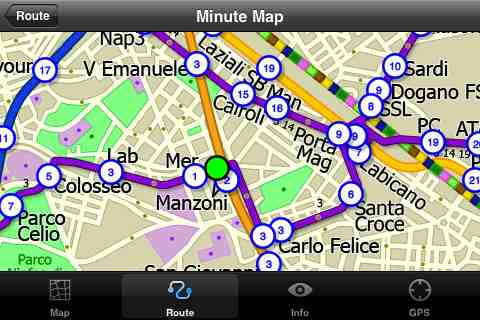
Rome Metro by Zuti - The "Rome Metro" application is a superb geographically based map and route planner for the Rome Metro, Tram, Urban and Regional rail systems. This application is one in a worldwide series of Zuti maps from Visual IT who have been producing public transportation maps for mobile devices for many years.
MAP
The map is hand drawn by Visual IT and provides a unique geographically based view of the city with many places of interest drawn directly on the background so you can easily get your bearings when traveling in and around the city. You can also use your inbuilt GPS (can also work with iPod Touch devices) to accurately locate and track yourself within the city centre and see the nearest transportation stop and distance to it. This is the only pubic transportation route planner with this ability.
Tap on the map for location information, use the inbuilt search feature or choose from a list of locations. Places of interest, museums, hotels, parks, restaurant, shops, hospitals, streets, etc, are also included. The route planner will automatically suggest the nearest station to any place of interest you select.
NO INTERNET CONNECTION REQUIRED
The map and routing does not require an internet connection and you will not be charged data connection fees. This also means the application runs successfully underground and on an iPod Touch. The only feature that requires an internet data connection is the “Live Info” which is optional and if used only requires a small amount of data.
ROUTING
Does not require an internet connection and will always be available to display a clear and detailed view of the city transport systems, plus list and animate the optimum route for your journey. Provides the fastest route calculations of any mobile routing application (virtually instantaneous) using actual published journey times with the ability to select the quickest route or the route with the least changes.
Comprehensive details of your planned route are provided, including changes, directions of travel, number of stops, predicted journey times, etc. Uniquely this application gives you “direction”, “towards” and “service frequency” information (not available on any other offline journey planner) for example “Take the Red line (Southbound) towards 95th/Dan Ryan for 6 stops. Service runs every 7 minutes” which is essential when finding the correct platform and connection. Also given are alternatives for each leg of the journey.
What's New in This Release:
· New map and routing.
· Improved "Travel Explorer" mode.
What's New in 1.4:
· Support for retina display
· New "Measure Tool"
· Bug fix for iOS 5
What's New in 1.3:
· Updated map and routes.
· Faster map loading.
· New route description text and layout.
· New "Take me home" option.
· New "Recent routes" option.
· Various other minor updates and improvements.
Like it? Share with your friends!
If you got an error while installing Themes, Software or Games, please, read FAQ.
Supported operating systems:
Apple iOS 10.x (iPad), Apple iOS 10.x (iPhone), Apple iOS 11.x (iPad), Apple iOS 12.x (iPad), Apple iOS 12.x (iPhone), Apple iOS 4.0.x (iPhone), Apple iOS 4.0.x (iPod Touch), Apple iOS 4.2.x (iPad), Apple iOS 4.2.x (iPhone), Apple iOS 4.2.x (iPod Touch), Apple iOS 4.3.x (iPad), Apple iOS 4.3.x (iPhone), Apple iOS 4.3.x (iPod Touch), Apple iOS 5.0 (iPad), Apple iOS 5.0 (iPhone), Apple iOS 5.0 (iPod Touch), Apple iOS 6.0 (iPad), Apple iOS 6.0 (iPhone), Apple iOS 6.0 (iPod Touch), Apple iOS 7.0 (iPad), Apple iOS 7.0 (iPhone), Apple iOS 7.0 (iPod Touch), Apple iOS 8.x (iPad), Apple iOS 8.x (iPhone), Apple iOS 8.x (iPod Touch), Apple iOS 9.x (iPad), Apple iOS 9.x (iPhone), Apple iOS 9.x (iPod Touch), Apple iPhone OS 3.1.x, Apple iPhone OS 3.1.x (iPod Touch), Apple iPhone OS 3.2.x (iPad)
Similar Software:
TransitM&S Nashville TransitM&S Nashville - TransitM&S is an easy-to-use transit application that provides bus info for Nashville's MTA.
The app is designed for offline use. It is ideal for iPod Touch users. Even for iPhone users, it is designed to save money because AT&T no longer offers the unlimited data plan
London Central Bus 10 London Central Bus 10 - The new Zuti London Bus map has finally arrived, making it easy to travel by bus anywhere in central London. This clear and colourful map covers a detailed street level area of 6 miles by 4 miles and includes over 1300 bus stops and 189 bus routes
TransitM&S New Orleans TransitM&S New Orleans - TransitM&S is an easy-to-use transit application that provides bus info for the metro New Orleans' Regional Transit Authority (RTA).
The app is designed for offline use. It is ideal for iPod Touch users. Even for iPhone users, it is designed to save money because AT&T no longer offers the unlimited data plan
Denver Daytrips Denver Daytrips - Visiting Denver and have a few hours, a day or more, and want to see the city, easily visit nearby towns and do some high-country exploring? Download this Denver Daytrips app, stick your iPhone in your pocket and head out. Or, grab your iPad and get going
TransitM&S Orlando TransitM&S Orlando - TransitM&S is an easy-to-use transit application that provides bus info LYNX Transit at the metro Orlando area.
The app is designed for offline use. It is ideal for iPod Touch users. Even for iPhone users, it is designed to save money because AT&T no longer offers the unlimited data plan
TransitGuru Portland TriMet The only transit app that offers offline schedules, system maps, multiple transportation types (train or bus) or agencies for single metro areas, alarms to wake you up when arrival, and integration with Yelp and Google Map
iBART Live iBART Live From the makers of the acclaimed iBART, iBART Live is an intelligent transit application for Bay Area Rapid Transit. It is essential to all BART riders — from the occasional to the daily, the tourist to the commuter
Berlin Metro 09 Berlin Metro 09 - The "Berlin Metro 09" application is a superb interactive map and route planner for the Berlin Metro (U-Bahn) and Suburban rail (S Bahn) systems. You can also use your inbuilt GPS (will also work with iPod Touch devices) to accurately locate and see the nearest transportation stop and distance to it
Tucson & the Old Southwest Tucson & the Old Southwest - Indian lands, Spanish colony, Mexican outpost, wild western American territory and finally the State of Arizona - the history of the lands surrounding the 'Old Pueblo' makes for fascinating diversity and exciting exploration. Saguaro-studded desert to riverine canyons to pine-topped mountains - the geography is equally as diverse
Essential Long Island Essential Long Island - Follow in the footsteps of F. Scott Fitzgerald along Long Island's fabulous Gold Coast estates. Picnic among the vineyards of the region’s burgeoning wine region. Discover Long Island’s own Rodeo Drive….and designer discount outlets. Dining, museum-hopping, mansion tours—this four-season guide has it all
Other Software by developer «Visual IT»:
Tube 2 Dublin Pro (Palm OS) Tube 2 Dublin Pro (Palm OS) - This map package for Tube 2 consists of a fully scrollable detailed map of the Dublin rail system and linked street maps of central Dublin.
Plan journeys on the rail system, list details of the quickest routes and see a superb animated display of your journey tracking around the system map
Rough Guides Map London Rough Guides Map London... These guides are a series of fantastic interactive maps.
Produced in conjunction with the premier travel publisher Rough Guides.
Discover and explore London using full colour interactive linked maps, in this simple to use PDA version of The Rough Guides London
Washington Metro by Zuti Washington Metro by Zuti - The new Washington Metro 10 map makes it easy to travel in and around the city using the WMATA Metro, MARC and VME systems. Also included are the Potomac river taxi routes and the DC Circulator bus routes
Tube Los Angeles (Series 60) Tube Los Angeles (Series 60) - Our highly acclaimed Tube application that guides you around the metro system of Los Angeles is now available for your Series 60 Symbian powered phone. An essential addition to your phone for locals and tourists alike.
· A detailed clear colour map of the LA metro system fully scrollable.
· Quick find station utility
Tube Toronto (Palm OS) Tube Toronto (Palm OS) - An award winning and highly acclaimed Palm OS application that guides you around the subway system of Toronto. An essential addition to your Palm device for locals and tourists alike.
Tube's features include:
A detailed clear colour (or grey scale) map of the transport system fully scrollable.
Quick find station utility
Tube Munich (UIQ) Tube Munich (UIQ) - An award winning and highly acclaimed application that guides you around the complex metro (S-Bahn / U-Bahn) system of Munich.
An essential addition to your P800 / P900 / P910 if if you travel in or around this city
· A detailed clear colour map of the Munich metro (S-Bahn / U-Bahn) system fully scrollable.
· Quick find station utility
Tube London City Streets (2009 Edition) Tube London City Streets
This Tube package consists of a fully scrollable detailed map of the London Underground system and 9 linked GPS enabled A-Z street maps.
Plan journeys on the London Underground system, list details of the quickest routes and see a superb animated display of your journey tracking around the system map
Tube 2 Portland (UIQ3) Tube 2 Portland (UIQ3) - This map package for Tube 2 consists of a fully scrollable detailed map of the Portland rail system.
Plan journeys on this system, list details of the quickest routes and see a superb animated display of your journey tracking around the system map
Tube Singapore (Series 60) Tube Singapore (Series 60) - Our highly acclaimed Tube application that guides you around the metro system of Singapore is now available for your Series 60 Symbian powered phone. An essential addition to your phone for locals and tourists alike.
· A detailed clear colour map of the Singapore metro system fully scrollable.
· Quick find station utility
Washington Metro for iPad by Zuti Washington Metro for iPad by Zuti - The new Washington Metro 10 map makes it easy to travel in and around the city using the WMATA Metro, MARC and VME systems. Also included are the Potomac river taxi routes and the DC Circulator bus routes


")


")
")
")
")
")
")
