Tyne & Wear Metro for iPad by Zuti - The new Tyne & Wear Metro map makes it easy to travel in and around the city using the Nexus Metro system. Unlike old fashioned schematic style maps this product contains a geographically accurate central area showing major streets, parks and places of interest etc, allowing the user to easily get their bearings.
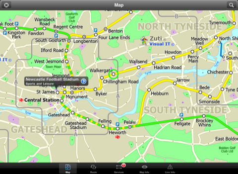
MAP
The map is hand drawn by Visual IT and provides a unique geographically based view of Tyne & Wear with many places of interest drawn directly on the background so you can easily get your bearings when traveling around the area. You can also use your inbuilt GPS to accurately locate and track yourself within the city centre and see the nearest transportation stop and distance to it. This is the only public transportation route planner with this ability.
Tap on the map for location information, use the inbuilt search feature or choose from a list of locations. Places of interest, museums, hotels, parks, restaurant, shops, hospitals, streets, etc, are also included. The route planner will automatically suggest the nearest station to any place of interest you select.
MINUTE MAP
Another great feature is the “Minute Map” option which allows you to see the travel times from a start point to all other locations on the map. This is a unique way to view the topology of an area and gauge traveling times.
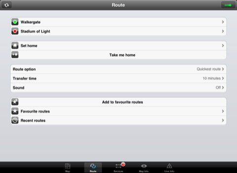
ROUTING
The application does not require an internet connection and will always be available to display a clear and detailed view of the city transport systems, plus list and animate the optimum route for your journey. This product provides the fastest route calculations of any mobile routing application (virtually instantaneous) using actual published journey times with the ability to select the quickest route or the route with the least changes.
LIVE INFO
When an internet connection is available, optional "Live Information" on the current state of the transport services can be viewed, allowing you to plan your journeys in advance and avoid any potential delays. Unique to this application is the ability to turn off services that are out of action and automatically calculate an alternative route.
· Full offline map and routing, no internet connection required.
· Colourful clear custom drawn geographically accurate mapping.
· Animates the route and allows tracking of the journey using GPS
· Instantly see the route of any transport service drawn on the map.
· Save and recall favourite and recent journeys.
· Take me home feature.
· Unique "Minute Map" feature allows quick view of all journey times from a start location.
· Services can be turned on or off, routing round problems.
· GPS location and tracking.
· Streets, Places of interest etc built into the application.
· Access to live service information.
What's New in This Release:
· Completely new map and routing.
· Many enhancements and added features.
Like it? Share with your friends!
If you got an error while installing Themes, Software or Games, please, read FAQ.
Supported operating systems:
Apple iOS 10.x (iPad), Apple iOS 11.x (iPad), Apple iOS 12.x (iPad), Apple iOS 4.2.x (iPad), Apple iOS 4.3.x (iPad), Apple iOS 5.0 (iPad), Apple iOS 6.0 (iPad), Apple iOS 7.0 (iPad), Apple iOS 8.x (iPad), Apple iOS 9.x (iPad), Apple iPhone OS 3.2.x (iPad)
Similar Software:
Bus: Gold Coast Bus: Gold Coast is a friendly timetable application that provides bus timetable for Gold Coast bus transport commuters. If you need an application to keep track of your favourite bus timetables in Gold Coast then this is for you!
· Access to timetables in Gold Coast, Australia.
· Save and remove favourite routes at the touch of a button
FlightTrack FlightTrack - The best flight tracking app out there. Track every aspect of your domestic and international flights with real-time updates and beautiful, zoomable maps. Check gate numbers, delays and cancellations
Agoda for iPhone/iPad Agoda for iPhone/iPad - Smarter hotel booking just got smarter.
agoda.com - a world of hotels in the palm of your hand.
The agoda.com advantage. To go.
· Over 160,000 hotels worldwide
· 1,000,000+ hotel reviews every year
· Free stays with agoda
Cold War Walking Tour in Berlin Cold War Walking Tour in Berlin - No place on Earth stood at the heart of the 20th Century conflict between the ideological poles of Communism and Capitalism like Berlin. A divided city in a divided Germany in a divided Europe in a divided world
Trip Journal Free (iPhone) Trip Journal is the #1 Travel Application with the best trip tracking, recording, documenting and sharing features currently available for the iPhone.
Trip Journal allows you to document vacation experiences and share them with your friends and family
TransitM&S Nashville TransitM&S Nashville - TransitM&S is an easy-to-use transit application that provides bus info for Nashville's MTA.
The app is designed for offline use. It is ideal for iPod Touch users. Even for iPhone users, it is designed to save money because AT&T no longer offers the unlimited data plan
Tokyo Metro for iPad by Zuti Tokyo Metro for iPad by Zuti - Tokyo Metro map makes it easy to travel in and around the city using the Toei Subway, JR East routes (within the Tokyo Suburban area), Shinkansen routes, Streetcars, some important private lines and Tokyo Cruise lines
TransitGuru Portland TriMet The only transit app that offers offline schedules, system maps, multiple transportation types (train or bus) or agencies for single metro areas, alarms to wake you up when arrival, and integration with Yelp and Google Map
London Underground by Zuti London Underground by Zuti - "London Underground 10" is a superb map and route planner for the London Underground, Overground and Docklands Light Railway (DLR) services. So you can make a quick exit when you leave the train we have now added exit information for all stations on the London Underground
London Tube for iPad by Zuti London Tube 10 is a superb geographically based map and route planner for the London Underground, Overground, Docklands Light Railway (DLR), Croydon Tramlink and London Airport Express services
Other Software by developer «Visual IT»:
San Francisco Metro 10 for iPad San Francisco Metro 10 for iPad - The new San Francisco Metro 10 application makes it easy to travel in and around the city using the Metro (BART), Streetcar, Light Rail(MUNI), Ferry and Presidio shuttle bus services
Tube 2 Beijing Geo (Palm OS) Tube 2 Beijing Geo (Palm OS) - This superb map package for Tube 2 is the ideal map for anyone who needs to get around Beijing using the public transport system.
The map is a comprehensive map of the Beijing subway system system accurately overlaid onto an informative street map
Paris Metro for iPad by Zuti Paris Metro 10 - This Zuti application contains a visually unique map of the Paris transport system and a superb animated journey planner to help you get around the Metro, RER, SNCF, Tram, Tvm, and Vogueo services. Now revised and updated to include a larger geographic area which covers more of the outlying areas surrounding Paris
Tube 2 Madrid (UIQ) Tube 2 Madrid (UIQ) - This map package for Tube 2 consists of a fully scrollable detailed map of the Madrid metro system.
Plan journeys on this system, list details of the quickest routes and see a superb animated display of your journey tracking around the system map
Beijing Subway by Zuti Beijing Subway by Zuti - The new Beijing Metro 10 map makes it easy to travel in and around the city using the Metro, Batong line, Airport Express line and Suburban S2 lines services
Tube Milan (Series 60) Tube Milan (Series 60) - Our highly acclaimed Tube application that guides you around the metro system of Milan is now available for your Series 60 Symbian powered phone. An essential addition to your phone for locals and tourists alike.
· A detailed clear colour map of the Milan metro system fully scrollable.
· Quick find station utility
Tube 2 Dublin Pro (UIQ3) Tube 2 Dublin Pro (UIQ3) - This map package for Tube 2 consists of a fully scrollable detailed map of the Dublin rail system and linked street maps of central Dublin.
Plan journeys on the rail system, list details of the quickest routes and see a superb animated display of your journey tracking around the system map
Tube 2 Brussels (UIQ) Tube 2 Brussels (UIQ) - This map package for Tube 2 consists of a fully scrollable detailed map of the Brussels tram, metro & bus system.
Plan journeys on these systems, list details of the quickest routes and see a superb animated display of your journey tracking around the system map
Edinburgh Mini A-Z Edinburgh Mini A-Z - This street map of Edinburgh covers an area extending to Cramond, Granton, Leith, Portobello, Musselburgh, Whitecraig, Dalkeith, Bonnyrigg (part), Loanhead, Fairmilehead, Juniper Green, Currie, Balerno, and Edinburgh Airport.
Major buildings are colour-coded to indicate places of interest and other buildings that are open to the public
Tube Moscow (UIQ) Tube Moscow (UIQ) - Our award winning and highly acclaimed application that guides you around the complex metro system of Moscow is now available for your Symbian UIQ phone.
An essential addition to your P800 / P900 / P910 if you travel in or around this city
· A detailed clear colour map of the Moscow metro system fully scrollable


")


")

")

")
")
")

")