Platforms: iPhone, iPad, iPod Touch, Apple iPhone OS
Categories: Travel & Navigation
Upload date: 4 Nov 11
Developer: Visual IT
License: Commercial
Price: 2.99 $
Downloads: 21
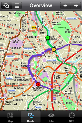
Vienna Metro by Zuti - This Zuti application contains a visually unique map of Vienna's transport systems and a superb animated journey planner to help you get around the Metro (U-Bahn), Suburban Rail (S-Bahn) and Tram (Stragenbahn). Unlike old fashioned schematic style maps this product contains a geographically accurate central area showing major streets, parks and places of interest etc, allowing the user to easily get their bearings in the city. This application is one in a worldwide series of Zuti maps from Visual IT who have been producing public transportation maps for mobile devices for many years.
MAP
The map is hand drawn by Visual IT and provides a unique geographically based view of the city with many places of interest drawn directly on the background. You can use your inbuilt GPS (can also work with iPod Touch devices) to accurately locate and track yourself within the city centre and see the nearest transportation stop and distance to it. This is the only pubic transportation route planner with this ability.
Tap on the map for location information, use the inbuilt search feature or choose from a list of locations. Places of interest, museums, hotels, parks, restaurant, shops, hospitals, streets, etc, are also included. The route planner will automatically suggest the nearest station to any place of interest you select.
NO INTERNET CONNECTION REQUIRED
The map and routing does not require an internet connection and you will not be charged data connection fees. This also means the application runs successfully underground and on an iPod Touch.
ROUTING
Does not require an internet connection and will always be available to display a clear and detailed view of the city transport systems, plus list and animate the optimum route for your journey. Provides the fastest route calculations of any mobile routing application (virtually instantaneous) using actual published journey times with the ability to select the quickest route or the route with the least changes.
Comprehensive details of your planned route are provided, including changes, directions of travel, number of stops, predicted journey times, etc. Uniquely this application gives you “direction”, “towards” and “service frequency” information (not available on any other offline journey planner) for example “Take the Red line (Southbound) towards 95th/Dan Ryan for 6 stops. Service runs every 7 minutes” which is essential when finding the correct platform and connection. Also given are alternatives for each leg of the journey.
What's New in This Release:
· Bug fix for iOS 5
· Support for retina display
· New "Measure Tool"
Like it? Share with your friends!
If you got an error while installing Themes, Software or Games, please, read FAQ.
Supported operating systems:
Apple iOS 10.x (iPad), Apple iOS 10.x (iPhone), Apple iOS 11.x (iPad), Apple iOS 12.x (iPad), Apple iOS 12.x (iPhone), Apple iOS 4.0.x (iPhone), Apple iOS 4.0.x (iPod Touch), Apple iOS 4.2.x (iPad), Apple iOS 4.2.x (iPhone), Apple iOS 4.2.x (iPod Touch), Apple iOS 4.3.x (iPad), Apple iOS 4.3.x (iPhone), Apple iOS 4.3.x (iPod Touch), Apple iOS 5.0 (iPad), Apple iOS 5.0 (iPhone), Apple iOS 5.0 (iPod Touch), Apple iOS 6.0 (iPad), Apple iOS 6.0 (iPhone), Apple iOS 6.0 (iPod Touch), Apple iOS 7.0 (iPad), Apple iOS 7.0 (iPhone), Apple iOS 7.0 (iPod Touch), Apple iOS 8.x (iPad), Apple iOS 8.x (iPhone), Apple iOS 8.x (iPod Touch), Apple iOS 9.x (iPad), Apple iOS 9.x (iPhone), Apple iOS 9.x (iPod Touch), Apple iPhone OS 3.1.x, Apple iPhone OS 3.1.x (iPod Touch), Apple iPhone OS 3.2.x (iPad)
Similar Software:
Tyne & Wear Metro for iPad by Zuti Tyne & Wear Metro for iPad by Zuti - The new Tyne & Wear Metro map makes it easy to travel in and around the city using the Nexus Metro system. Unlike old fashioned schematic style maps this product contains a geographically accurate central area showing major streets, parks and places of interest etc, allowing the user to easily get their bearings
Best Western to Go With ‘Best Western to Go’ you can find locations and make reservations for any Best Western hotel worldwide, track details of your trip and share your trip details with friends and family.
Starting out, ’Best Western to Go’ will load your current location and highlight nearby Best Western hotels
Viva Las Vegas, Baby! Viva Las Vegas, Baby! - Don't waste a single second of your next escape to Las Vegas. Get under the skin of the city right now, from the neon-lit Strip to downtown's Fremont Street and beyond
San Antonio Driving Tours This revolutionary application presents you several driving tours designed to show you the best of the city, as it comes with detailed tour route maps and powerful navigation features to guide you from one sight to the next
Madrid Metro for iPad by Zuti Madrid Metro for iPad by Zuti - Madrid Metro map makes it easy to travel in and around the city using the the Metro, Renfe Rail and Metro Ligero Rail services. Unlike old fashioned schematic style maps this product contains a geographically accurate central area showing major streets, parks and places of interest etc, allowing the user to easily get their bearings
Dallas(Texas) World Travel Dallas(Texas) World Travel - Map with locate me function makes you free to move.
Background reading always accompanies you on your trip
Vermont Winter Fun Vermont Winter Fun - When the temperature takes a dive, crack into this application for a feast of activities, from mild to wild, to keep you entertained and out savoring the natural beauty of the Green Mountain State, in ways you might not have thought of until now
Chamonix World Travel Chamonix World Travel - Map with locate me function makes you free to move.
Background reading always accompanies you on your trip
Happy Hours Happy Hours, the nation's premier happy hour guide, shows all of the food and drink specials going on near you. Click through to see a photo of the bar or restaurant, and details such as the menu, location, amenities, and what other people have to say. Our happy hour ranks are based on the community, so don't forget to vote up your favorite spots
Canberra Bus Canberra Bus is a friendly timetable application that provides bus timetable for Canberra bus transport commuters. If you need an application to keep track of your favorite bus timetables throughout Canberra then this is for you!
· Access to all timetables in Canberra, Australia.
· Save and remove favorite routes at the touch of a button
Other Software by developer «Visual IT»:
Great Britain Rail by Zuti Great Britain Rail by Zuti - The new Great Britain Rail map makes it easy to travel in and around the country using the rail services. This application contains a geographically accurate map of the whole of Great Britain allowing you to easily view the route of any journey
Tube Chicago Pro (Palm OS) Tube Chicago Pro (Palm OS) - This award winning and highly acclaimed Palm application that guides you around the subway system of Chicago now comes in a pro version with these extra features :
A superb full colour street level map of the downtown Chicago area with a find feature that enables you to quickly find any street, place of interest or station on the map
Rough Guides Map Rome Rough Guides Map Rome... These guides are a series of fantastic interactive maps.
Produced in conjunction with the premier travel publisher Rough Guides.
Discover and explore Rome using full colour interactive linked maps, in this simple to use PDA version of The Rough Guides Rome
Tube Munich (Palm OS) Tube Munich (Palm OS) - An award winning and highly acclaimed Palm OS application that guides you around the metro (S-Bahn / U-Bahn) system of Munich. An essential addition to your Palm device for locals and tourists alike.
Tube's features include:
A detailed clear colour (or grey scale) map of the transport system fully scrollable.
Quick find station utility
Tube 2 Engine Pocket PC Tube 2 Engine - Transform your PDA into a fully scrollable detailed map of one of the worlds subway or metro systems.
See your journeys come alive with a superb animated display.
Save hours by automatically having the quickest routes to hand, with all the details you need including line changes, platform directions and accurate journey times
Tube 2 Seoul (UIQ3) Tube 2 Seoul (UIQ3) - This map package for Tube 2 consists of a fully scrollable detailed map of the Seoul Metropolitan Subway system.
Plan journeys on this system, list details of the quickest routes and see a superb animated display of your journey tracking around the system map
Tube Frankfurt (Palm OS) Tube Frankfurt (Palm OS) - An award winning and highly acclaimed Palm OS application that guides you around the metro (S-Bahn / U-Bahn) system of Frankfurt. An essential addition to your Palm device for locals and tourists alike.
Tube's features include:
A detailed clear colour (or grey scale) map of the transport system fully scrollable.
Quick find station utility
London Visitors A-Z for iPad London Visitors A-Z for iPad - The London Visitors A-Z map of central London is designed especially for the tourist
Tube 2 Barcelona Pro (UIQ3) Tube 2 Barcelona Pro (UIQ3) - This map package for Tube 2 consists of a fully scrollable detailed map of the Barcelona metro & rail system and linked street maps of central Barcelona.
Plan journeys on the metro system, list details of the quickest routes and see a superb animated display of your journey tracking around the system map
Tube Madrid (Series 60) Tube Madrid (Series 60) - Our highly acclaimed Tube application that guides you around the complex metro system of Madrid is now available for your Series 60 Symbian powered phone. An essential addition to your phone for locals and tourists alike.
· A detailed clear colour map of the Madrid metro system fully scrollable.
· Quick find station utility


 World Travel")


")

")

")
")

")
")