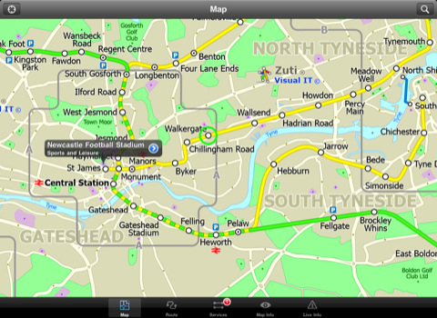
Tyne & Wear Metro for iPad by Zuti - The new Tyne & Wear Metro map makes it easy to travel in and around the city using the Nexus Metro system. Unlike old fashioned schematic style maps this product contains a geographically accurate central area showing major streets, parks and places of interest etc, allowing the user to easily get their bearings.
MAP
The map is hand drawn by Visual IT and provides a unique geographically based view of Tyne & Wear with many places of interest drawn directly on the background so you can easily get your bearings when traveling around the area. You can also use your inbuilt GPS to accurately locate and track yourself within the city centre and see the nearest transportation stop and distance to it. This is the only public transportation route planner with this ability.
Tap on the map for location information, use the inbuilt search feature or choose from a list of locations. Places of interest, museums, hotels, parks, restaurant, shops, hospitals, streets, etc, are also included. The route planner will automatically suggest the nearest station to any place of interest you select.
MINUTE MAP
Another great feature is the “Minute Map” option which allows you to see the travel times from a start point to all other locations on the map. This is a unique way to view the topology of an area and gauge traveling times.
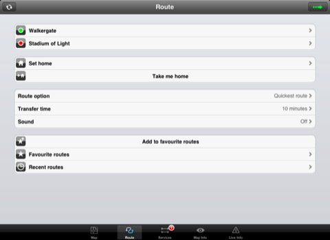
ROUTING
The application does not require an internet connection and will always be available to display a clear and detailed view of the city transport systems, plus list and animate the optimum route for your journey. This product provides the fastest route calculations of any mobile routing application (virtually instantaneous) using actual published journey times with the ability to select the quickest route or the route with the least changes.
LIVE INFO
When an internet connection is available, optional "Live Information" on the current state of the transport services can be viewed, allowing you to plan your journeys in advance and avoid any potential delays. Unique to this application is the ability to turn off services that are out of action and automatically calculate an alternative route.
· Full offline map and routing, no internet connection required.
· Colourful clear custom drawn geographically accurate mapping.
· Animates the route and allows tracking of the journey using GPS
· Instantly see the route of any transport service drawn on the map.
· Save and recall favourite and recent journeys.
· Take me home feature.
· Unique "Minute Map" feature allows quick view of all journey times from a start location.
· Services can be turned on or off, routing round problems.
· GPS location and tracking.
· Streets, Places of interest etc built into the application.
· Access to live service information.
What's New in This Release:
· Completely new map and routing.
· Many enhancements and added features.
Like it? Share with your friends!
If you got an error while installing Themes, Software or Games, please, read FAQ.
Supported operating systems:
Apple iOS 10.x (iPad), Apple iOS 11.x (iPad), Apple iOS 12.x (iPad), Apple iOS 4.2.x (iPad), Apple iOS 4.3.x (iPad), Apple iOS 5.0 (iPad), Apple iOS 6.0 (iPad), Apple iOS 7.0 (iPad), Apple iOS 8.x (iPad), Apple iOS 9.x (iPad), Apple iPhone OS 3.2.x (iPad)
Similar Software:
San Francisco Metro for iPad by Zuti San Francisco Metro for iPad by Zuti - The new San Francisco Metro 10 application makes it easy to travel in and around the city using the Metro (BART), Streetcar, Light Rail(MUNI), Ferry and Presidio shuttle bus services
Via de la Plata Via de la Plata - Spain's Vía de la Plata is the longest pilgrimage route to Compostela, stretching 1,000 kilometers from Sevilla to Santiago. This guide, through more than 75 entries and 750 photos, currently covers the stretch from Sevilla to Mérida
London Underground for iPad by Zuti London Underground 10 is a superb map and route planner for the London Underground, Overground and Docklands Light Railway (DLR) services. So you can make a quick exit when you leave the train we have now added exit information for all stations on the London Underground
Hotels.com for iPad Hotels.com for iPad - Hotels.com allows you to quickly find a hotel and book a room right from your iPad. The app includes a database of more than 150,000 hotels from 200 countries, complete with photos, ratings and reviews from customers.
The application allows you to search for hotels nearby or at the specified destination, and view their location on a map
Booking.com for iPhone/iPad 5.6. Booking.com for iPhone/iPad 5.6. - Booking.com allows you to quickly find and book hotels right from your iPhone, iPad or iPod touch. The app includes a database of more than 250,000 places to stay from all over the world, along with over 17 million guest reviews and more than 2.6 million hotel photos.
With Booking
Denver Maps Denver Maps - Software that helps you download and store the travel maps and plans you need. This super-handy app lets you download publicly available maps and store them on your iPhone or iPod Touch. You can download the maps when you have fast wifi connection - and then use any time in the future without delay
Tyne & Wear Metro by Zuti Tyne & Wear Metro by Zuti - The new Tyne & Wear Metro map makes it easy to travel in and around the city using the Nexus Metro system. Unlike old fashioned schematic style maps this product contains a geographically accurate central area showing major streets, parks and places of interest etc, allowing the user to easily get their bearings
Bars & Clubs Bars & Clubs is an easy-to-use, quick, and convenient way to find a bar or night club near you.
Bars & Clubs quickly identifies your location and lets you choose the nearest Local Bar, Pub, Lounge, Sports Bar, Wine Bar, Billiard Bar, Brewery, Comedy Club, etc..
Las Vegas Maps Las Vegas Maps - software that helps you download and store the travel maps and plans you need. This super-handy app lets you download publicly available maps and store them on your iPhone or iPod Touch. You can download the maps when you have fast wifi connection - and then use any time in the future without delay
StayHIP StayHIP is the best way to find and book boutique hotels. StayHIP brings you only the most chic and unique hotels in the world all with lush pictures, lists of amenities and the ability to search for your hotel by keywords. And you can book your room right in the application
Other Software by developer «Visual IT»:
London Mini A-Z for iPad London Mini A-Z for iPad - This clear and colourful high quality map is a digital rendition of the famous "London A-Z Mini Atlas" and covers an area from West Hendon in the North West to Grove Park in the South East. Add this application to you iPad and you will have instant access to all 352 pages of the London Mini A-Z printed map
Tube 2 Rome Pro (UIQ) Tube 2 Rome Pro (UIQ) - This map package for Tube 2 consists of a fully scrollable detailed map of the Rome metro & rail system and linked high quality street maps of central Rome.
Plan journeys on the metro system, list details of the quickest routes and see a superb animated display of your journey tracking around the system map
Beijing Subway for iPad by Zuti Beijing Subway for iPad by Zuti - Beijing Metro map makes it easy to travel in and around the city using the Beijing metro system and also includes the S2 rail line to the Great Wall at Badaling
Tube 2 London (UIQ3) Tube 2 London (UIQ3) - This map package for Tube 2 consists of a fully scrollable detailed map of the London Underground system.
Plan journeys on the London Underground system, list details of the quickest routes and see a superb animated display of your journey tracking around the system map
Tube 2 Paris Pro (Palm OS) Tube 2 Paris Pro (Palm OS) - This map package for Tube 2 consists of a fully scrollable detailed map of the Paris metro & RER system and linked high quality street maps of central Paris.
Plan journeys on the metro & RER system, list details of the quickest routes and see a superb animated display of your journey tracking around the system map
London Visitors A-Z London Visitors A-Z - The London Visitors Map of central London is designed especially for the tourist. The principal feature of the mapping is the highlighting of places of interest, buildings open to the public, theatres, cinemas, selected shops and stores, main shopping streets, main line and underground railway stations and other locations of interest to the visitor
Rough Guides Map Amsterdam Rough Guides Map Amsterdam... These guides are a series of fantastic interactive maps.
Produced in conjunction with the premier travel publisher Rough Guides.
Discover and explore Amsterdam using full colour interactive linked maps, in this simple to use PDA version of The Rough Guides Amsterdam
Tube 2 Amsterdam Pro (UIQ) Tube 2 Amsterdam Pro (UIQ) - This map package for Tube 2 consists of a fully scrollable detailed map of the Amsterdam tram & metro system and linked street maps of central Amsterdam.
Plan journeys on the tram & metro system, list details of the quickest routes and see a superb animated display of your journey tracking around the system map
Tube 2 London Pro (UIQ) Tube 2 London Pro (UIQ) - This map package for Tube 2 consists of a fully scrollable detailed map of the London Underground system and 2 linked A-Z street maps.
Plan journeys on the London Underground system, list details of the quickest routes and see a superb animated display of your journey tracking around the system map
London Congestion Charge Map (Palm OS) London Congestion Charge Map (Palm OS) - This map package is an essential addition to your Tube 2 maps if you drive in or around central London.
This reference map gives you a clear view of the area now covered by the congestion charge system, complete with a quick find utility to help you find any major road or street in and around the area


")

")
")


")
")
")