Platforms: iPhone, iPad, iPod Touch, Apple iPhone OS
Categories: Travel & Navigation
Upload date: 31 May 13
Developer: Visual IT
License: Freeware
Downloads: 19
London Bus Free - The new Zuti London Bus map has finally arrived, making it easy to travel by bus anywhere in central London. This clear and colourful map covers a detailed street level area of 6 miles by 4 miles and includes over 1300 bus stops and 189 bus routes.
All day and night bus routes running through the central area are covered in full and this means routes run to Wembley, Edgware, Edmonton, Ilford, Woolwich, Croydon and Richmond in the day and to Uxbridge, Harrow Weald, Stanmore, Kingston, Edgware, Barnet, Heathrow Airport, Enfield, Waltham Cross, Hainault, Romford, Erith (Bexleyheath), Foots Cray, St. Paul's Cray, New Addington, Old Coulsdon, and Sutton at night.
The map and routing information is stored completely on the device and needs no internet connection, making it ideal for iPod Touch and iPhone users visiting the UK who want to avoid paying roaming charges.
MAP
The map is hand drawn by Visual IT and provides a unique geographically based view of the city with many places of interest drawn directly on the background so you can easily get your bearings when traveling in and around the city. You can also use your inbuilt GPS (can also work with iPod Touch devices) to accurately locate and track yourself within the city centre and see the nearest transportation stop and distance to it. This is the only pubic transportation route planner with this ability.
Tap on the map for location information, use the inbuilt search feature or choose from a list of locations. Places of interest, museums, hotels, parks, restaurant, shops, hospitals, streets, etc, are also included. The route planner will automatically suggest the nearest station to any place of interest you select.
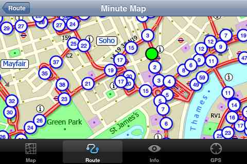
MINUTE MAP
Another unique feature of this product is our “Minute Map” option which allows you to see the travel times from a start point to all other locations on the map. This can be very useful and is not available in any other product on the market.
NO INTERNET CONNECTION REQUIRED
The map and routing does not require an internet connection and you will not be charged data connection fees. This also means the application runs successfully underground and on an iPod Touch. The only feature that requires an internet data connection is the “Live Info” which is optional and if used only requires a small amount of data.
ROUTING
Does not require an internet connection and will always be available to display a clear and detailed view of the city bus transport system, plus list and animate the optimum route for your journey. Provides the fastest route calculations of any mobile routing application (virtually instantaneous) using actual published journey times with the ability to select the quickest route or the route with the least changes.
What's New in This Release:
· Update for new devices.
· Now a universal app (works on iPhone, iPod or iPad).
· New features
Like it? Share with your friends!
If you got an error while installing Themes, Software or Games, please, read FAQ.
Supported operating systems:
Apple iOS 10.x (iPad), Apple iOS 10.x (iPhone), Apple iOS 11.x (iPad), Apple iOS 12.x (iPad), Apple iOS 12.x (iPhone), Apple iOS 4.3.x (iPad), Apple iOS 4.3.x (iPhone), Apple iOS 4.3.x (iPod Touch), Apple iOS 5.0 (iPad), Apple iOS 5.0 (iPhone), Apple iOS 5.0 (iPod Touch), Apple iOS 6.0 (iPad), Apple iOS 6.0 (iPhone), Apple iOS 6.0 (iPod Touch), Apple iOS 7.0 (iPad), Apple iOS 7.0 (iPhone), Apple iOS 7.0 (iPod Touch), Apple iOS 8.x (iPad), Apple iOS 8.x (iPhone), Apple iOS 8.x (iPod Touch), Apple iOS 9.x (iPad), Apple iOS 9.x (iPhone), Apple iOS 9.x (iPod Touch)
Similar Software:
Chicago Metro for iPad by Zuti Chicago Metro for iPad by Zuti - Chicago Metro map makes it easy to travel in and around the city using the CTA rapid transport system, the commuter services of Metrarail, Northern Indiana Commuter Transportation District and also the Water Taxi services
Trip Journal Free (iPhone) Trip Journal is the #1 Travel Application with the best trip tracking, recording, documenting and sharing features currently available for the iPhone.
Trip Journal allows you to document vacation experiences and share them with your friends and family
TransitM&S Orlando TransitM&S Orlando - TransitM&S is an easy-to-use transit application that provides bus info LYNX Transit at the metro Orlando area.
The app is designed for offline use. It is ideal for iPod Touch users. Even for iPhone users, it is designed to save money because AT&T no longer offers the unlimited data plan
Lufthansa for iPhone Lufthansa for iPhone - The Lufthansa app turns your iPhone into a handy travel assistant.
With it, you can book Lufthansa flights from your mobile, check flight status, view the timetable and check in.
In addition, the application allows you to quickly access your personal travel details and your Miles & More account
AddTo Chicago AddTo Chicago - shows you some of your favorite Chicago locations like Millennium Park, Navy Pier and the Art Institute, great public art like the Bean, the Picasso, the Four Seasons mosaic mural and less well known locations like Powell's bookstore and Lou Mitchell's. AddTo Chicago lets you create your own map, photo album and travel diary
Philadelphia Maps Philadelphia Maps - software that helps you download and store the travel maps and plans you need. This super-handy app lets you download publicly available maps and store them on your iPhone or iPod Touch. You can download the maps when you have fast wifi connection - and then use any time in the future without delay
ebookers for iPhone/iPad ebookers for iPhone/iPad - ebookers provides an easy way to find and book hotels right from your iPhone. The app includes a database of thousands of places to stay from all over the world, complete with photos, ratings and reviews from customers.
ebookers uses GPS to show you all the hotels nearby
FlightTrack Pro FlightTrack Pro - the best flight tracking app out there. Get push alerts, real-time flight itinerary updates, automatic synching, and beautiful, zoomable maps that work offline. Flight cancelled? It will even help you find alternate flights.
FlightTrack Pro works seamlessly with TripIt. Forward your airline confirmation emails to plans@tripit
Vienna Metro for iPad by Zuti Vienna Metro for iPad by Zuti - The new Zuti Vienna Metro map makes it easy to travel in and around the city using the Metro (U-Bahn), Suburban Rail (S-Bahn) or Tram (Stragenbahn) systems
Other Software by developer «Visual IT»:
Tube 2 Madrid (Palm OS) Tube 2 Madrid (Palm OS) - This map package for Tube 2 consists of a fully scrollable detailed map of the Madrid metro system.
Plan journeys on this system, list details of the quickest routes and see a superb animated display of your journey tracking around the system map
London Visitors A-Z for iPad London Visitors A-Z for iPad - The London Visitors A-Z map of central London is designed especially for the tourist
Tube 2 Amsterdam Pro (UIQ) Tube 2 Amsterdam Pro (UIQ) - This map package for Tube 2 consists of a fully scrollable detailed map of the Amsterdam tram & metro system and linked street maps of central Amsterdam.
Plan journeys on the tram & metro system, list details of the quickest routes and see a superb animated display of your journey tracking around the system map
Tube Munich (UIQ) Tube Munich (UIQ) - An award winning and highly acclaimed application that guides you around the complex metro (S-Bahn / U-Bahn) system of Munich.
An essential addition to your P800 / P900 / P910 if if you travel in or around this city
· A detailed clear colour map of the Munich metro (S-Bahn / U-Bahn) system fully scrollable.
· Quick find station utility
Tube 2 London Bus (UIQ3) Tube 2 London Bus (UIQ3) - This map package for Tube 2 consists of a fully scrollable detailed map of the central London TFL bus system.
You can now plan your bus journeys with ease, the application will list details of all the quickest routes, list alternative routes and show travel times
London Bus by Zuti London Bus by Zuti - The new Zuti London Bus map has finally arrived, making it easy to travel by bus anywhere in central London. This clear and colourful map covers a detailed street level area of 6 miles by 4 miles and includes over 1300 bus stops and 189 bus routes
Tube 2 Budapest (Palm OS) Tube 2 Budapest (Palm OS) - This map package for Tube 2 consists of a fully scrollable detailed map of the Budapest metro system and HEV suburban railway.
Plan journeys on this system, list details of the quickest routes and see a superb animated display of your journey tracking around the system map
Tube Toronto (UIQ) Tube Toronto (UIQ) - Our award winning and highly acclaimed application guides you around the subway system of Toronto is now available for your Symbian UIQ phone.
An essential addition to your P800 / P900 / P910 if you travel in or around this city
· A detailed clear colour map of the Toronto subway system fully scrollable.
· Quick find station utility
Tube 2 Baltimore (UIQ) Tube 2 Baltimore (UIQ) - This map package for Tube 2 consists of a fully scrollable detailed map of the Baltimore metro & rail system.
Plan journeys on this system, list details of the quickest routes and see a superb animated display of your journey tracking around the system map
Tube 2 Dublin Pro (Palm OS) Tube 2 Dublin Pro (Palm OS) - This map package for Tube 2 consists of a fully scrollable detailed map of the Dublin rail system and linked street maps of central Dublin.
Plan journeys on the rail system, list details of the quickest routes and see a superb animated display of your journey tracking around the system map


")


")

")
")
")

")
")
")
")