New York Subway for iPad by Zuti - The "New York Subway" application is a superb geographically based map and route planner for the New York public transport systems. It also contains an animated journey planner to help you get around the Subway, Long Island Rail Road, Metro-North Railroad, New Jersey Transit and a number of ferry services provided by NY Waterway and New York Water Taxi. This application is one in a worldwide series of Zuti maps from Visual IT who have been producing public transportation maps for mobile devices for many years.
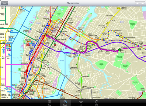
MAP
The map is hand drawn by Visual IT and provides a unique geographically based view of the city with many places of interest drawn directly on the background so you can easily get your bearings when traveling in and around the city. You can also use your inbuilt GPS (can also work with iPod Touch devices) to accurately locate and track yourself within the city centre and see the nearest transportation stop and distance to it. This is the only pubic transportation route planner with this ability.
Tap on the map for location information, use the inbuilt search feature or choose from a list of locations. Places of interest, museums, hotels, parks, restaurant, shops, hospitals, streets, etc, are also included. The route planner will automatically suggest the nearest station to any place of interest you select.
NO INTERNET CONNECTION REQUIRED
The map and routing does not require an internet connection and you will not be charged data connection fees. This also means the application runs successfully underground and on an iPod Touch. The only feature that requires an internet data connection is the “Live Info” which is optional and if used only requires a small amount of data.
ROUTING
Does not require an internet connection and will always be available to display a clear and detailed view of the city transport systems, plus list and animate the optimum route for your journey. Provides the fastest route calculations of any mobile routing application (virtually instantaneous) using actual published journey times with the ability to select the quickest route or the route with the least changes.
MINUTE MAP
Another unique feature of this product is our “Minute Map” option which allows you to see the travel times from a start point to all other locations on the map. This can be very useful and as far as we know not available in any other product on the market.
What's New in This Release:
· Completely new map and routing.
· Many enhancements and added features.
What's New in 1.4:
· Bug fix for iOS 5
· New "Measure Tool"
Like it? Share with your friends!
If you got an error while installing Themes, Software or Games, please, read FAQ.
Supported operating systems:
Apple iOS 10.x (iPad), Apple iOS 11.x (iPad), Apple iOS 12.x (iPad), Apple iOS 4.2.x (iPad), Apple iOS 4.3.x (iPad), Apple iOS 5.0 (iPad), Apple iOS 6.0 (iPad), Apple iOS 7.0 (iPad), Apple iOS 8.x (iPad), Apple iOS 9.x (iPad), Apple iPhone OS 3.2.x (iPad)
Similar Software:
TransitM&S Metro Transit TransitM&S Metro Transit - TransitM&S is an easy-to-use transit application that provides bus and train info for the metro Minneapolis' Metro Transit.
The app is designed for offline use. It is ideal for iPod Touch users. Even for iPhone users, it is designed to save money because AT&T no longer offers the unlimited data plan
Best Western to Go With ‘Best Western to Go’ you can find locations and make reservations for any Best Western hotel worldwide, track details of your trip and share your trip details with friends and family.
Starting out, ’Best Western to Go’ will load your current location and highlight nearby Best Western hotels
TransitM&S Nashville TransitM&S Nashville - TransitM&S is an easy-to-use transit application that provides bus info for Nashville's MTA.
The app is designed for offline use. It is ideal for iPod Touch users. Even for iPhone users, it is designed to save money because AT&T no longer offers the unlimited data plan
London Bus London Bus - The new Zuti London Bus map has finally arrived, making it easy to travel by bus anywhere in central London. This clear and colourful map covers a detailed street level area of 6 miles by 4 miles and includes over 1300 bus stops and 189 bus routes
Trip Journal (iPhone) Trip Journal (iPhone) is the #1 Google Awarded Travel Application with the best trip tracking, recording, documenting and sharing features currently available for iPhone.
Trip Journal allows you to document vacation experiences and share them with your friends and family
New York Subway by Zuti New York Subway by Zuti - The "New York Subway" application is a superb geographically based map and route planner for the New York public transport systems
Lufthansa for iPhone Lufthansa for iPhone - The Lufthansa app turns your iPhone into a handy travel assistant.
With it, you can book Lufthansa flights from your mobile, check flight status, view the timetable and check in.
In addition, the application allows you to quickly access your personal travel details and your Miles & More account
London City Maps Lite London City Maps Lite - software that helps you download and store the travel maps and plans you need. This super-handy app lets you download publicly available maps and store them on your iPhone or iPod Touch. You can download the maps when you have fast wifi connection - and then use any time in the future without delay
Tyne & Wear Metro for iPad by Zuti Tyne & Wear Metro for iPad by Zuti - The new Tyne & Wear Metro map makes it easy to travel in and around the city using the Nexus Metro system. Unlike old fashioned schematic style maps this product contains a geographically accurate central area showing major streets, parks and places of interest etc, allowing the user to easily get their bearings
TripDeck TripDeck - The best itinerary organizer out there – and it’s FREE. Manage your hotel reservations, car rentals, flights, cruises, restaurants, meetings and more with easy-to-read Trip Decks for each itinerary. You can also view your entire itinerary on a gorgeous map
Other Software by developer «Visual IT»:
Tube 2 Hong Kong (UIQ3) Tube 2 Hong Kong (UIQ3) - This map package for Tube 2 consists of a fully scrollable detailed map of the Hong Kong metro & rail system.
Plan journeys on this system, list details of the quickest routes and see a superb animated display of your journey tracking around the system map
Washington Metro by Zuti Washington Metro by Zuti - The new Washington Metro 10 map makes it easy to travel in and around the city using the WMATA Metro, MARC and VME systems. Also included are the Potomac river taxi routes and the DC Circulator bus routes
The Pad (V3) The Pad (V3) - The Pad... This simple yet invaluable application is the fastest way to write and draw on a Windows Mobile Professional / Pocket PC PDA or phone
Tube 2 San Francisco Pro (UIQ) Tube 2 San Francisco Pro (UIQ) - This map package for Tube 2 consists of fully scrollable detailed maps of the San Francisco metro & rail systems and linked high quality street maps of central San Francisco.
The maps in this package cover the BART, SCVTA & Caltrain systems plus the Municipal Metro, Municipal Historic Street Car and Cable Car systems in central SF
Barcelona Metro for iPad by Zuti Barcelona Metro for iPad by Zuti - This Zuti application contains a visually unique map of the Barcelona transport system and a superb animated journey planner to help you get around the TMB (Transports Metropolitan de Barcelona), FGC (Ferrocarrils de la Generalitat de Catalunya) Metro and Tram services
TUBE 2 Amsterdam Pro TUBE 2 Amsterdam Pro - This map package for Tube 2 consists of a fully scrollable detailed map of the Amsterdam tram & metro system and linked street maps of central Amsterdam.
Plan journeys on the tram & metro system, list details of the quickest routes and see a superb animated display of your journey tracking around the system map
Tube 2 Amsterdam (UIQ) Tube 2 Amsterdam (UIQ) - This map package for Tube 2 consists of a fully scrollable detailed map of the Amsterdam tram & metro system.
Plan journeys on this system, list details of the quickest routes and see a superb animated display of your journey tracking around the system map
Tube 2 San Francisco Pro (Palm OS) Tube 2 San Francisco Pro (Palm OS) - This map package for Tube 2 consists of fully scrollable detailed maps of the San Francisco metro & rail systems and linked high quality street maps of central San Francisco
Digital Camera Guide (Palm OS) Digital Camera Guide (Palm OS) - An essential guide for anyone new to the world of digital photography. In a simple easy to read format with superb photographs it helps you to get the most from your camera and explains how many of the complicated features of your camera work.
Index of subjects covered:
- Camera Controls
Tube Portland (Series 60) Tube Portland (Series 60) - Our highly acclaimed Tube application that guides you around the rail system of Portland is now available for your Series 60 Symbian powered phone. An essential addition to your phone for locals and tourists alike.
· A detailed clear colour map of the Portland rail system fully scrollable.
· Quick find station utility


")


")

")
")


")
")
")
")