Platforms: iPhone, iPad, iPod Touch, Apple iPhone OS
Categories: Travel & Navigation
Upload date: 7 May 11
Developer: Flytomap
License: Commercial
Price: 12.99 $
Downloads: 23
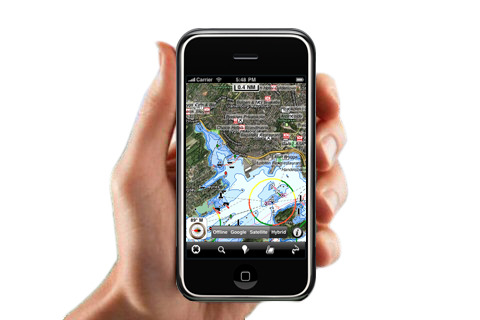
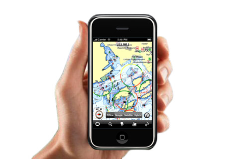
Marine: South West England - GPS Map Navigator - FlytoMap provides complete, quick and easy to use map applications for navigation for iPhone. Continues in the tradition of offering depth of information and functionality across expected places all over the world, exploring the map you get maximum details obtaining detailed information of every object on the map.
FlytoMap processes different types of maps for navigation for different categories:
WATER MAPS (Marine):
Water map navigator is the new ‘Marine Navigator for iPhone’ contains embedded Electronic Nautical Charts (ENC) from NOAA compressed to a large coverage. You can now download the application and transform your iPhone in a chart plotter with best NOAA, ENC S57 cartography; which includes Anchoring areas, Fishing areas, restriction areas, obstructions, rocks, Buoys, Beacons, Lights, Depth contours with Values display on map, Spot Soundings and more. The only marine app available in the market with such huge information. Every effort is made to be as accurate as possible when presenting information for every destination.
PARK MAPS:
Park map applications are extremely advanced contains embedded electronic charts with all information collected from the National Park Service and local sources. The maps contain all multiple trails (Hiking, biking, Stairway trails, Bicycle trails, Equestrian trails etc.,) and Point of interests (POI) like Campgrounds, Eating places, Ranger Stations, Picnic areas, Boat/Canoe launching, Parking areas etc., which are provided depending on the relevant park areas they exist.
LAKE MAPS:
We offer high quality lake maps with detailed information and important features compressed to assure the larger coverage in USA region. Lake maps contain most important DNR lakes with detailed ‘Depth Contours, Boat Ramps, Fishing spots etc. Also includes Trails, Roads and Railways information.
TRAVEL MAPS:
These Maps treat you mostly with information of both Marine and terrain correspondingly. These are the most preferable Maps to travel especially for fascinating recreational voyages, map focus the best Beach spots along the Coast line, Major ports, Sailing, Fishing, Picnic areas, Parks, Hiking, Biking, Clubs, restaurants, Famous Hotels, Museums, Shopping areas, and much more.
· Use Latitudes and Longitudes to go to your favorite places
· Insert the target/destination 'Waypoint' and see in real time your speed, distance and direction to destination
· Insert Unlimited Markers near favorite places on the map
· Search your Favorite points directly
· Zoom, Rotate and Pan fast just by a finger touch
· Navigate and see your GPS position on the map
· Geo-Tagged photo management
· Set On/Off Elevation Contours if you feel data is cluttering
What's New in This Release:
· Minor bug fixed
· Retina display management
Like it? Share with your friends!
If you got an error while installing Themes, Software or Games, please, read FAQ.
Supported operating systems:
Apple iOS 10.x (iPad), Apple iOS 10.x (iPhone), Apple iOS 11.x (iPad), Apple iOS 12.x (iPad), Apple iOS 12.x (iPhone), Apple iOS 4.0.x (iPhone), Apple iOS 4.0.x (iPod Touch), Apple iOS 4.2.x (iPad), Apple iOS 4.2.x (iPhone), Apple iOS 4.2.x (iPod Touch), Apple iOS 4.3.x (iPad), Apple iOS 4.3.x (iPhone), Apple iOS 4.3.x (iPod Touch), Apple iOS 5.0 (iPad), Apple iOS 5.0 (iPhone), Apple iOS 5.0 (iPod Touch), Apple iOS 6.0 (iPad), Apple iOS 6.0 (iPhone), Apple iOS 6.0 (iPod Touch), Apple iOS 7.0 (iPad), Apple iOS 7.0 (iPhone), Apple iOS 7.0 (iPod Touch), Apple iOS 8.x (iPad), Apple iOS 8.x (iPhone), Apple iOS 8.x (iPod Touch), Apple iOS 9.x (iPad), Apple iOS 9.x (iPhone), Apple iOS 9.x (iPod Touch), Apple iPhone OS 3.1.x, Apple iPhone OS 3.1.x (iPod Touch), Apple iPhone OS 3.2.x (iPad)
Similar Software:
NAVIGON MobileNavigator New Zealand NAVIGON MobileNavigator New Zealand - With the NAVIGON MobileNavigator you can transform your iPhone into a fully functional mobile navigation system that is every bit as good as the multi-award-winning personal navigation devices from NAVIGON in terms of its user-friendliness and features
CoPilot Truck HD North America CoPilot Truck HD North America - Introducing CoPilot Truck HD—the first iPad app that provides full-featured voice-guided GPS navigation designed specifically for professional drivers of trucks
Navmii GPS Germany HD Navmii GPS Germany HD - Navmii is a powerful GPS navigation solution for iOS devices. The app features turn-by-turn directions, voice guidance, automatic rerouting, live Google and Microsoft Bing Search, and more.
Navmii uses offline maps which are stored locally on the device, so there is no need for a data connection
CoPilot Live France CoPilot Live France - Welcome to CoPilot Live, the award winning turn-by-turn iPhone sat navigation app with complete street maps of France and door to door voice directions.
CoPilot Live is packed full of advanced navigation features to guide you easily and accurately, including clear 3D map displays, lane indicator arrows and speed limit alerts
Garmin StreetPilot Download Garmin StreetPilot and get Garmin award-winning navigation, similar to the premium features on Garmin’s renowned nüvi personal navigators. Designed exclusively for your iPhone or iPad, this mobile application turns your device into a GPS navigator with turn-by-turn voice-prompted directions and premium features for wherever you want to go
Navfree GPS Live India Navfree GPS Live India - Navfree is a free GPS navigation solution for iOS devices. The app uses OpenStreetMap data, created and updated by thousands of users from all over the world.
The maps are stored locally on the device, so there is no need for a data connection
Dearborn(Michigan) World Travel Dearborn(Michigan) World Travel - Map with locate me function makes you free to move.
Background reading always accompanies you on your trip
Marine: Alaska South East - GPS Map Navigator Marine: Alaska South East - GPS Map Navigator - FlytoMap provides complete, quick and easy to use map applications for navigation for iPhone. Continues in the tradition of offering depth of information and functionality across expected places all over the world, exploring the map you get maximum details obtaining detailed information of every object on the map
Donana National Park - GPS Map Navigator Donana National Park - GPS Map Navigator - FlytoMap provides complete, quick and easy to use map applications for navigation for iPhone. Continues in the tradition of offering depth of information and functionality across expected places all over the world, exploring the map you get maximum details obtaining detailed information of every object on the map
Navmii GPS Austria HD Navmii GPS Austria HD - Navmii is a powerful GPS navigation solution for iOS devices. The app features turn-by-turn directions, voice guidance, automatic rerouting, live Google and Microsoft Bing Search, and more.
Navmii uses offline maps which are stored locally on the device, so there is no need for a data connection
Other Software by developer «Flytomap»:
Hunting Map - Colorado Hunting Map - Colorado - iHunt - Colorado is the best hunting map product available today on the market.
You can Navigate in real time looking your position on the map, you don't need internet connection, switch off the 3G and double your iPhone battery life.
It is a collection of the best hunting maps available for Colorado
Crete (Greece) - GPS Map Navigator Crete (Greece) - GPS Map Navigator - FlytoMap provides complete, quick and easy to use map applications for navigation for iPhone. Continues in the tradition of offering depth of information and functionality across expected places all over the world, exploring the map you get maximum details obtaining detailed information of every object on the map
Shawnee National Forest - Standard Shawnee National Forest - Standard - Continues in the tradition of offering depth of information and functionality across expected places all over the world, exploring the map you get maximum details obtaining detailed information of each object on the map
Big Bend National Park - GPS Map Navigator Big Bend National Park - GPS Map Navigator - Continues in the tradition of offering depth of information and functionality across expected places all over the world, exploring the map you get maximum details obtaining detailed information of each object on the map
Joshua Tree National Park - Standard Joshua Tree National Park - Standard - Continues in the tradition of offering depth of information and functionality across expected places all over the world, exploring the map you get maximum details obtaining detailed information of each object on the map
Cape Verde Islands - GPS Map Navigator Cape Verde Islands - GPS Map Navigator - FlytoMap provides complete, quick and easy to use map applications for navigation for iPhone. Continues in the tradition of offering depth of information and functionality across expected places all over the world, exploring the map you get maximum details obtaining detailed information of every object on the map
Marine: Brisbane HD - GPS Map Navigator Marine: Brisbane HD - GPS Map Navigator - FlytoMap provides complete, quick and easy to use map applications for navigation for iPad. Continues in the tradition of offering depth of information and functionality across expected places all over the world, exploring the map you get maximum details obtaining detailed information of every object on the map
Grenadines & Grenada - GPS Map Navigator Grenadines & Grenada - GPS Map Navigator - FlytoMap provides complete, quick and easy to use map applications for navigation. Continues in the tradition of offering depth of information and functionality across expected places all over the world, exploring the map you get maximum details obtaining detailed information of every object on the map
Allegheny National Forest - GPS Map Navigator Allegheny National Forest - GPS Map Navigator - Continues in the tradition of offering depth of information and functionality across expected places all over the world, exploring the map you get maximum details obtaining detailed information of each object on the map
Marine: Cherbourg to Channel Islands - Solent Marine: Cherbourg to Channel Islands - Solent - Cherbourg to Channel Islands is a high quality map with detailed water navigation information and important features compressed to assure the bigger coverage.
Map contains embedded electronic nautical charts from IHO's compressed to a large coverage


 World Travel")


 - GPS Map Navigator")


