Platforms: iPhone, iPad, iPod Touch, Apple iPhone OS
Categories: Travel & Navigation
Upload date: 18 Jan 12
Developer: Flytomap
License: Commercial
Price: 2.99 $
Downloads: 20
Nationalpark Vorpommersche Boddenlandschaft - GPS Map Navigator - FlytoMap provides complete, quick and easy to use map applications for navigation for iPhone. Continues in the tradition of offering depth of information and functionality across expected places all over the world, exploring the map you get maximum details obtaining detailed information of every object on the map.
FlytoMap processes different types of maps for navigation for different categories:
WATER MAPS (Marine):
Water map navigator is the new ‘Marine Navigator for iPhone’ contains embedded Electronic Nautical Charts (ENC) from NOAA compressed to a large coverage. You can now download the application and transform your iPhone in a chart plotter with best NOAA, ENC S57 cartography; which includes Anchoring areas, Fishing areas, restriction areas, obstructions, rocks, Buoys, Beacons, Lights, Depth contours with Values display on map, Spot Soundings and more. The only marine app available in the market with such huge information. Every effort is made to be as accurate as possible when presenting information for every destination.
PARK MAPS:
Park map applications are extremely advanced contains embedded electronic charts with all information collected from the National Park Service and local sources. The maps contain all multiple trails (Hiking, biking, Stairway trails, Bicycle trails, Equestrian trails etc.,) and Point of interests (POI) like Campgrounds, Eating places, Ranger Stations, Picnic areas, Boat/Canoe launching, Parking areas etc., which are provided depending on the relevant park areas they exist.
LAKE MAPS:
We offer high quality lake maps with detailed information and important features compressed to assure the larger coverage in USA region. Lake maps contain most important DNR lakes with detailed ‘Depth Contours, Boat Ramps, Fishing spots etc. Also includes Trails, Roads and Railways information.
TRAVEL MAPS:
These Maps treat you mostly with information of both Marine and terrain correspondingly. These are the most preferable Maps to travel especially for fascinating recreational voyages, map focus the best Beach spots along the Coast line, Major ports, Sailing, Fishing, Picnic areas, Parks, Hiking, Biking, Clubs, restaurants, Famous Hotels, Museums, Shopping areas, and much more.
· Use Latitudes and Longitudes to go to your favorite places
· Insert the target/destination 'Waypoint' and see in real time your speed, distance and direction to destination
· Insert Unlimited Markers near favorite places on the map
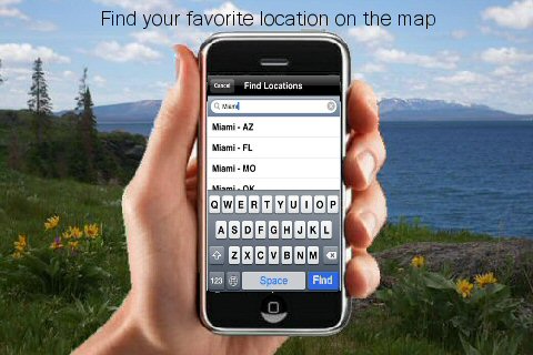
· Search your Favorite points directly
· Zoom, Rotate and Pan fast just by a finger touch
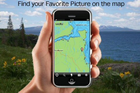
· Navigate and see your GPS position on the map
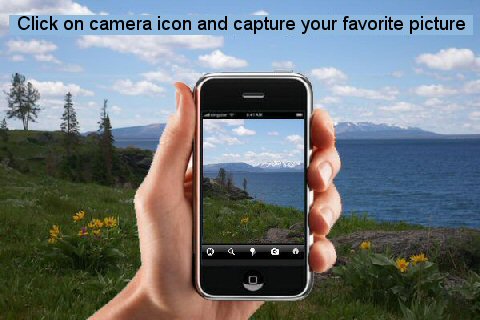
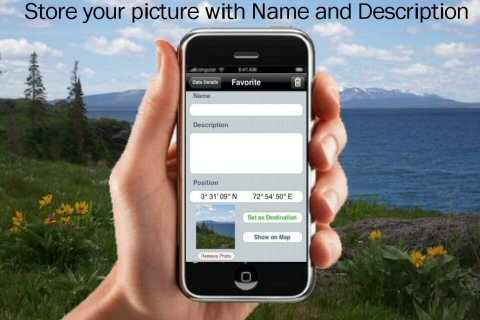
· Geo-Tagged photo management
· Set On/Off Elevation Contours if you feel data is cluttering
What's New in This Release:
· GPS Info Page
· Faster Names Search
What's New in 2.5.1:
· Minor bug Fixed
Like it? Share with your friends!
If you got an error while installing Themes, Software or Games, please, read FAQ.
Supported operating systems:
Apple iOS 10.x (iPad), Apple iOS 10.x (iPhone), Apple iOS 11.x (iPad), Apple iOS 12.x (iPad), Apple iOS 12.x (iPhone), Apple iOS 4.0.x (iPhone), Apple iOS 4.0.x (iPod Touch), Apple iOS 4.2.x (iPad), Apple iOS 4.2.x (iPhone), Apple iOS 4.2.x (iPod Touch), Apple iOS 4.3.x (iPad), Apple iOS 4.3.x (iPhone), Apple iOS 4.3.x (iPod Touch), Apple iOS 5.0 (iPad), Apple iOS 5.0 (iPhone), Apple iOS 5.0 (iPod Touch), Apple iOS 6.0 (iPad), Apple iOS 6.0 (iPhone), Apple iOS 6.0 (iPod Touch), Apple iOS 7.0 (iPad), Apple iOS 7.0 (iPhone), Apple iOS 7.0 (iPod Touch), Apple iOS 8.x (iPad), Apple iOS 8.x (iPhone), Apple iOS 8.x (iPod Touch), Apple iOS 9.x (iPad), Apple iOS 9.x (iPhone), Apple iOS 9.x (iPod Touch), Apple iPhone OS 3.1.x, Apple iPhone OS 3.1.x (iPod Touch), Apple iPhone OS 3.2.x (iPad)
Similar Software:
Aaland Islands - GPS Map Navigator Aaland Islands - GPS Map Navigator - FlytoMap provides complete, quick and easy to use map applications for navigation for iPhone. Continues in the tradition of offering depth of information and functionality across expected places all over the world, exploring the map you get maximum details obtaining detailed information of every object on the map
Nav4D Estonia Nav4D Estonia - Single intuitive menu gives the user all the information needed to begin a journey with confidence. Along the way take advantage of the automatic local and global search with rich contents.
Designed to attract everyone, the new interface concept makes usability and design a key point. Nav4D is the perfect navigation system for iPhone
NAVIGON MobileNavigator British Isles NAVIGON MobileNavigator British Isles - With the NAVIGON MobileNavigator you can transform your iPhone into a fully functional mobile navigation system that is every bit as good as the multi-award-winning personal navigation devices from NAVIGON in terms of its user-friendliness and features
Navfree GPS Live Sweden Navfree GPS Live Sweden - Navfree is a free GPS navigation solution for iOS devices. The app uses OpenStreetMap data, created and updated by thousands of users from all over the world.
The maps are stored locally on the device, so there is no need for a data connection
LiveViewGPS The LiveViewGPS Mobile Utility allows you to locate any LiveViewGPS "Live-Trac" series gps tracking device from your iPhone (You must have a "Live-Trac" gps tracking device (PT-10 series, G5, RTV5 or Nav Trac system to use this application).
View your assets, vehicle(s) and even any person anytime, or from anywhere in the world from your iPhone
WHERE (iPhone) WHERE - Are you ready to delete dozens of other applications from your iPhone? WHERE is the only application you'll need you need for location based information.
WHERE connects you to people, places and things around you
Heidelberg Maps Offline Heidelberg Maps Offline - This will be perfect when you are traveling and you don't have internet connection. This Offline Maps is not a replacement of Google Maps. It is used when you don't have internet connection and want to use maps
Death Valley National Park - GPS Map Navigator Death Valley National Park - GPS Map Navigator continues in the tradition of offering depth of information and functionality across expected places all over the world, exploring the map you get maximum details obtaining detailed information of each object on the map
Augusta (GA, USA) Map Offline Augusta (GA, USA) Map Offline - This will be perfect when you are traveling and you don't have internet connection. This Offline Maps is not a replacement of Google Maps. It is used when you don't have internet connection and want to use maps
Yonkers - New Rochelle (NY) Maps Offline Yonkers - New Rochelle (NY) Maps Offline - This will be perfect when you are traveling and you don't have internet connection. This Offline Maps is not a replacement of Google Maps. It is used when you don't have internet connection and want to use maps
Other Software by developer «Flytomap»:
Snowdonia National Park - GPS Map Navigator Snowdonia National Park - GPS Map Navigator - FlytoMap provides complete, quick and easy to use map applications for navigation for iPhone. Continues in the tradition of offering depth of information and functionality across expected places all over the world, exploring the map you get maximum details obtaining detailed information of every object on the map
Dominican Republic - GPS Map Navigator Dominican Republic - GPS Map Navigator - FlytoMap provides complete, quick and easy to use map applications for navigation for iPhone. Continues in the tradition of offering depth of information and functionality across expected places all over the world, exploring the map you get maximum details obtaining detailed information of every object on the map
Asinara National Park - GPS Map Navigator Asinara National Park - GPS Map Navigator - FlytoMap provides complete, quick and easy to use map applications for navigation for iPhone. Continues in the tradition of offering depth of information and functionality across expected places all over the world, exploring the map you get maximum details obtaining detailed information of every object on the map
Majella National Park - GPS Map Navigator Majella National Park - GPS Map Navigator - FlytoMap provides complete, quick and easy to use map applications for navigation for iPhone. Continues in the tradition of offering depth of information and functionality across expected places all over the world, exploring the map you get maximum details obtaining detailed information of every object on the map
Hong Kong - GPS Map Navigator Hong Kong - GPS Map Navigator - FlytoMap provides complete, quick and easy to use map applications for navigation for iPhone. Continues in the tradition of offering depth of information and functionality across expected places all over the world, exploring the map you get maximum details obtaining detailed information of every object on the map
Saint Martin - GPS Map Navigator Saint Martin - GPS Map Navigator - FlytoMap provides complete, quick and easy to use map applications for navigation for iPhone. Continues in the tradition of offering depth of information and functionality across expected places all over the world, exploring the map you get maximum details obtaining detailed information of every object on the map
Comoros Islands HD - GPS Map Navigator Comoros Islands HD - GPS Map Navigator - FlytoMap provides complete, quick and easy to use map applications for navigation for iPad. Continues in the tradition of offering depth of information and functionality across expected places all over the world, exploring the map you get maximum details obtaining detailed information of every object on the map
Parco dei Cetacei - (Marine: Mar Ligure) - GPS Map Navigator Parco dei Cetacei - (Marine: Mar Ligure) - GPS Map Navigator - Liguria region is well-known by international travelers from more than a century and have recognized the warmth and beauty of the magnificent Italian Riviera. Best place to enjoy warm water, wide sandy beaches, and posh resorts, discriminating travelers to come and explore
Yellowstone National Park - Standard Yellowstone National Park - Standard - Continues in the tradition of offering depth of information and functionality across expected places all over the world, exploring the map you get maximum details obtaining detailed information of each object on the map
Marine: (Huron-Erie-Ontario) HD - GPS Map Navigator Marine: (Huron-Erie-Ontario) HD - GPS Map Navigator - FlytoMap provides complete, quick and easy to use map applications for navigation for iPad. Continues in the tradition of offering depth of information and functionality across expected places all over the world, exploring the map you get maximum details obtaining detailed information of every object on the map


")


 Map Offline")
 Maps Offline")


 - GPS Map Navigator")

 HD - GPS Map Navigator")