Star Walk for iPad - Enjoy Global Astronomy Month 2010 (GAM 2010) together with Star Walk: observe the most important astronomical events, get to know everything about meteor showers, messier objects, stars, and constellations.
Star Walk is your personal planetarium that can answer to all your curiosities about the sky! For anyone who is interested in stargazing, amateurs or professionals Star Walk makes discovering more than 9,000 stars, planets, constellations, messiers as beautiful and easy as it has never been before!
Star Walk features and how to use them:
DIGITAL COMPASS: tilt your iPad and the ''Star Spotter'' function will be activated, a live representation of what you see in the sky will appear on your display and the sky will start following your movements right, left, up, and down.
TIME MACHINE: tap the clock icon and scroll the time slider to watch the sky tonight or lets say two years from now. Travel in time and observe night sky on your birthday, be a part of astronomical events like eclipses and meteor showers.
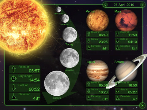
SKY LIVE Window: open up the new window by tapping the moon-shaped button to see moon phases, elevation, and rising data for the Sun, Venus, Mercury, Jupiter, and Saturn.
PICTURE of the DAY: Tap the right hand corner menu button, select glowing "Picture of the Day" button and a list of pictures will open in front of you. To learn more about the pictures tap the -i- icon on the top right hand corner.
BOOKMARKS: save a reminder of beautiful night sky observations, bookmark it on your iPad and view it at any time.
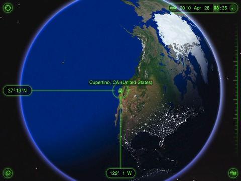
VIEW from the EARTH: Automatic and manual selection of locations on a 3D globe.
MOON PHASES: select the SKY LIVE window and see the moon phases for several days. Change the date on the top to see the moon phases for the past or for the future. Or zoom in the image of Moon and scroll the time slider.
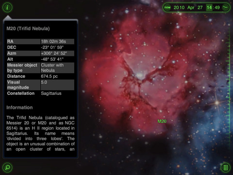
Wikipedia LINKS: select one celestial body and tap the - i - icon to activate the magnifier and read main information about it. To know more tap the Wiki icon at the bottom of the table and the Wikipedia page will open up.
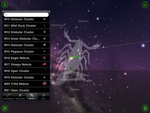
SEARCH celestial objects: you can also search for stars, planets, and messier objects by their names and see where they are on the sky tonight and when they are going to be visible in your region.
SETTINGS: with the settings you can modify user preferences like you can change the screen to night mode, select brightness of the stars (change stars magnitude with a slider), put sounds and music on or off, switch on or off the constellations images.
HELP GUIDE: the help tab includes some basic instruction on how to use time machine and location selection. FAQ section includes some common questions from our users and answers to them. For any doubts, suggestions or concerns contact us via support e-mail, Twitter or Facebook fan page.
What's New in This Release:
· "Frost" feature removed
What's New in 5.5:
The update employs new technology introduced in iOS 5:
· Twitter Enhanced for iOS 5
· #starwalk Community: a new interface for communication between Star Walk users all over the world
· The Twitter messages that include #starwalk will appear on a spinnable globe: a great way to communicate with stargazers all over the world
The update also includes lots of minor tweaks and bug fixes:
· Improved AirPlay
· Fixed Dec and Asm for some stars
· Bug with Star Spotter on iPod 4 with iOS 5 fixed
What's New in 5.4:
· External HD TV support improvement: lets explore the Universe on a large external screen with friends or classmates.
· The multi-wavelength view of the Sky: lets you explore our Galaxy and the distant Universe in a range of wavelengths from X-rays to the longest radio waves.
· The official partnership of StarWalk project with ESA (European Space Agency): more valuable and proofread content in the app.
What's New in 5.3:
· Now the StarWalk database includes up to 8000 artificial satellites such as
· New video tutorial for quick overview of main features and how-to instructions
What's New in 5.1.2:
· Optimization: runs faster and smoother
· Less space on your device: app size reduced by 40%
· Bug fix
Like it? Share with your friends!
If you got an error while installing Themes, Software or Games, please, read FAQ.
Supported operating systems:
Apple iOS 10.x (iPad), Apple iOS 11.x (iPad), Apple iOS 12.x (iPad), Apple iOS 4.2.x (iPad), Apple iOS 4.3.x (iPad), Apple iOS 5.0 (iPad), Apple iOS 6.0 (iPad), Apple iOS 7.0 (iPad), Apple iOS 8.x (iPad), Apple iOS 9.x (iPad), Apple iPhone OS 3.2.x (iPad)
Similar Software:
HubbleSite HubbleSite, the online home of NASA’s Hubble Space Telescope, invites you to help choose the world’s most popular Hubble images. Get wallpapers, Hubble facts, and more.
Hubble’s vast collection of images awaits your critical and discerning eye
Night Sky 2 for iPhone/iPad Night Sky 2 for iPhone/iPad - Night Sky 2 is a useful app that allows astronomy enthusiasts to quickly identify celestial bodies.
Simply point your iPhone, iPad or iPod touch at a star, constellation, planet or other object in the sky and the software will tell you its name
LunaSolCal for iPhone/iPad LunaSolCal for iPhone/iPad calculates times of sunrise, sunset, moonrise and moonset for your location at any given date
Mars Envi Mars Envi - It's the best way to review decades worth of Mars missions, and to check out the latest happenings there
Redshift Redshift - Redshift brings the night sky to your iOS device, with all major and dwarf planets, constellations and bright stars - displayed in top quality. The application goes beyond the basic planetarium because it also displays a 3D-model of the nearby part of our Galaxy.
Perform various amazing 3-D flights and visit the Moon and all planets in our Solar system
Earth Envi Earth Envi - OK, maybe not quite, but Earth Envi gives you access to some of the most amazing Web-based space photos of our home planet that you'll ever see
Sky Above Sky Above - Sky Above is an iOS app which tells you where stars, constellations, planets and satellites are above you in the sky. The application also uses augmented reality to show the real sky using the device's camera. Just hold your iPhone or iPad up to the sky and the names of the sky objects will be overlayed on the camera display
SkySafari 3 Pro SkySafari 3 Pro - SkySafari Pro is a chart star app for all astronomy enthusiasts. It includes a comprehensive database of 15.3 million stars, 740,000 galaxies down to 18th magnitude, and over 580,000 solar system objects.
In addition, the application displays the Solar System's planets along with their moons, as well as every comet and asteroid ever discovered
Phases for iPad Phases for iPad View the moon phase, age, illumination, moonrise, moonset and much more for any date or time. Choose a city from our massive database of over 20,000 cities or use your iPad's GPS to show even more accurate information
SkyView SkyView - Where will the Sun rise and set today? Is there a Full Moon tonight? Where is the constellation Orion? Am I looking at a bright star or a planet? What are some fun facts about these objects?
SkyView is a powerful and easy-to-use application that answers these questions and more
Other Software by developer «VITO Technology»:
VITO QuickContact UIQ QuickContact is a simple yet powerful contact manager adapted for ONE HAND operation. Extremely useful for those who never use the flip. The main feature of QuickContact is a character-specific search method. Based on alphabetic filtering of names in the list it helps to operate hundreds of your contacts in a flash, much faster then a built-in Contacts can provide
Map of Western Siberia Map of Western Siberia - A map of Western Siberia. Includes following regions:
ALTAYSKIY KRAY
KEMEROVSKAYA OBLAST''
NOVOSIBIRSKAYA OBLAST''
OMSKAYA OBLAST''
RESPUBLIKA ALTAY
TOMSKAYA OBLAST''
Good for intercity travels with SmartMap
Map of Saudi Arabia Bundle of Saudi Arabia maps consisting of 14 territories. Each map is accompanied by a short text description. Good for intercity travels with VITO SmartMap and VITO SmartNavigator
Map of Thailand Map of Thailand - A map of Thailand, divided into 72 smaller territories for the ease of use. Good for intercity travels with SmartMap.
Layers include: Towns - Settlements - Airports - Roads - Railroads - Rivers - Inland water - Administrative borders - International borders - Trees. Map scale is 1:1 million.
Good for use with any version of SmartMap
VITO SoundExplorer UIQ VITO SoundExplorer is the first application to record MP3 audio on SonyEricsson P800/P900. It allows you to save lots of memory space just by keeping all your recordings in this popular multimedia format. Length of recording is limited only by your free memory size. Record to any location in your phone directly, including your Memory Stick Duo
Map of New Zealand Map of New Zealand - A map of New Zealand.
Good for intercity travels with SmartMap.
Layers include:
Towns
Settlements
Airports
Roads
Railroads
Rivers
Inland water
Administrative borders
International borders
Trees
Map scale is 1:1 million.
Good for use with any version of SmartMap
Map of Taiwan Map of Taiwan -
A map of Taiwan good for intercity travels with SmartMap.
Layers include:
Towns
Settlements
Airports
Roads
Railroads
Rivers
Inland water
Administrative borders
International borders
Trees
Map scale is 1:1 million.
Good for use with any version of SmartMap. SmartMap can be purchased here
Map of New Mexico (US State) Map of New Mexico (US State) - A map of the New Mexico by VITO Technology. Good for intercity travels with SmartMap.
SmartMap is a mobile device application which uses vector and raster maps. It is compatible with any NMEA protocol GPS receiver (Compact Flash socket, serial port, BlueTooth or sleeve)
Map of South Carolina (US State) Map of South Carolina (US State) - A map of the South Carolina by VITO Technology. Good for intercity travels with SmartMap.
SmartMap is a mobile device application which uses vector and raster maps. It is compatible with any NMEA protocol GPS receiver (Compact Flash socket, serial port, BlueTooth or sleeve)
Map of Pakistan Map of Pakistan - A map of Pakistan. Good for intercity travels with SmartMap.
Layers include:
Towns
Settlements
Airports
Roads
Railroads
Rivers
Inland water
Administrative borders
International borders
Trees
Map scale is 1:1 million.
Good for use with any version of SmartMap. SmartMap can be purchased here


")
")
