Platforms: iPhone, iPad, iPod Touch, Apple iPhone OS
Categories: Travel & Navigation
Upload date: 28 May 13
Developer: Visual IT
License: Commercial
Price: 1.99 $
Downloads: 15
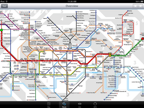
London Underground for iPad by Zuti - "London Underground 10" is a superb map and route planner for the London Underground, Overground and Docklands Light Railway (DLR) services. So you can make a quick exit when you leave the train we have now added exit information for all stations on the London Underground. The map and routing information is stored completely on the device and needs no internet connection, making it ideal for iPad users visiting the UK who want to avoid paying roaming charges.
MAP
The map is the official TFL (Transport For London) map. You can use your inbuilt GPS (will also work with iPod Touch devices) to accurately locate the nearest transportation stop and distance to it. Tap on the map for location information, use the inbuilt search feature or choose from a list of locations. Places of interest, museums, hotels, parks, restaurant, shops, hospitals, streets, etc, are also included. The route planner will automatically suggest the nearest station to any place of interest you select.
MINUTE MAP
Another unique feature of is the “Minute Map” option which allows you to see the travel times from a start point to all other locations on the map. This can be very useful and is not available in any other product on the market.
INTERNET CONNECTION
The map and routing do not require an internet connection and you will not be charged data connection fees. This also means the application runs successfully underground.
ROUTING
Does not require an internet connection and will always be available to display a clear and detailed view of the city transport systems, plus list and animate the optimum route for your journey. Provides the fastest route calculations of any mobile routing application (virtually instantaneous) using actual published journey times with the ability to select the quickest route or the route with the least changes.
Comprehensive details of your planned route are provided, including changes, directions of travel, number of stops, predicted journey times, etc. Uniquely this application gives you “direction”, “towards” and “service frequency” information for each segment of the journey (not available on any other offline journey planner) for example “At Kings Cross change to the Hammersmith and City line (Eastbound) towards Barking for 3 stops. Service runs every 7 minutes” which is essential when finding the correct platform and connection. Also given are alternatives for each segment of the journey.
TRAIN + STATION EXITS
Contains simple information on every Tube station indicating what carriage to use for the most efficient exit or transfer. Just tap on a Tube station and scroll down to see the exit information for each platform.
LIVE INFO
When an internet connection is available, optional "Live Information" on the current state of the transport services can be viewed (and automatically saved for future reference) allowing you to plan your journeys in advance and avoid any potential delays. Unique to this application is the ability to turn off services that are out of action and automatically calculate an alternative route.
What's New in This Release:
· Minor bug fixes
Like it? Share with your friends!
If you got an error while installing Themes, Software or Games, please, read FAQ.
Supported operating systems:
Apple iOS 10.x (iPad), Apple iOS 10.x (iPhone), Apple iOS 11.x (iPad), Apple iOS 12.x (iPad), Apple iOS 12.x (iPhone), Apple iOS 4.3.x (iPad), Apple iOS 4.3.x (iPhone), Apple iOS 4.3.x (iPod Touch), Apple iOS 5.0 (iPad), Apple iOS 5.0 (iPhone), Apple iOS 5.0 (iPod Touch), Apple iOS 6.0 (iPad), Apple iOS 6.0 (iPhone), Apple iOS 6.0 (iPod Touch), Apple iOS 7.0 (iPad), Apple iOS 7.0 (iPhone), Apple iOS 7.0 (iPod Touch), Apple iOS 8.x (iPad), Apple iOS 8.x (iPhone), Apple iOS 8.x (iPod Touch), Apple iOS 9.x (iPad), Apple iOS 9.x (iPhone), Apple iOS 9.x (iPod Touch)
Similar Software:
Call a Hotel Call a Hotel - this app means you can instantly find a hotel - whenever you need it. Wherever you are in the world!
In 2 clicks you will be talking to the closest hotel to your current location.
Never get stuck for accommodation in a strange city or late at night again. Buy it for your wife, girlfriend, husband, boyfriend now! Even better - buy it for yourself
Berlin Metro 09 Berlin Metro 09 - The "Berlin Metro 09" application is a superb interactive map and route planner for the Berlin Metro (U-Bahn) and Suburban rail (S Bahn) systems. You can also use your inbuilt GPS (will also work with iPod Touch devices) to accurately locate and see the nearest transportation stop and distance to it
Boston Subway for iPad by Zuti Boston Subway for iPad by Zuti - This Boston Subway map makes it easy to travel in and around the city using the MBTA Subway, MBTA Commuter Rail, MBTA Boats, and Massport shuttle buses. Unlike old fashioned schematic style maps this product contains a geographically accurate central area showing major streets, parks and places of interest etc
London Bus by Zuti London Bus by Zuti - The new Zuti London Bus map has finally arrived, making it easy to travel by bus anywhere in central London. This clear and colourful map covers a detailed street level area of 6 miles by 4 miles and includes over 1300 bus stops and 189 bus routes
Atlanta Maps Atlanta Maps - software that helps you download and store the travel maps and plans you need. This super-handy app lets you download publicly available maps and store them on your iPhone or iPod Touch. You can download the maps when you have fast wifi connection - and then use any time in the future without delay
Hong Kong Subway by Zuti Hong Kong Subway by Zuti - The new Hong Kong Metro 10 map makes it easy to travel in and around the city using the MTR transit railway, MTR light rail, MTR Airport Express, Trams, Cable Car and Ferry services
Trip Journal Free (iPhone) Trip Journal is the #1 Travel Application with the best trip tracking, recording, documenting and sharing features currently available for the iPhone.
Trip Journal allows you to document vacation experiences and share them with your friends and family
Booking.com for iPhone/iPad 6.0. Booking.com for iPhone/iPad 6.0. - Booking.com allows you to quickly find and book hotels right from your iPhone, iPad or iPod touch. The app includes a database of more than 250,000 places to stay from all over the world, along with over 17 million guest reviews and more than 2.6 million hotel photos.
With Booking
ebookers for iPhone/iPad ebookers for iPhone/iPad - ebookers provides an easy way to find and book hotels right from your iPhone. The app includes a database of thousands of places to stay from all over the world, complete with photos, ratings and reviews from customers.
ebookers uses GPS to show you all the hotels nearby
TransitM&S Nashville TransitM&S Nashville - TransitM&S is an easy-to-use transit application that provides bus info for Nashville's MTA.
The app is designed for offline use. It is ideal for iPod Touch users. Even for iPhone users, it is designed to save money because AT&T no longer offers the unlimited data plan
Other Software by developer «Visual IT»:
TUBE 2 Rome (Palm OS) TUBE 2 Rome (Palm OS) - This map package for Tube 2 consists of a fully scrollable detailed map of the Rome metro & rail system.
Plan journeys on this system, list details of the quickest routes and see a superb animated display of your journey tracking around the system map.
A Pro version is also available with integrated high quality street maps of central Rome
Rough Guides Map Amsterdam Rough Guides Map Amsterdam... These guides are a series of fantastic interactive maps.
Produced in conjunction with the premier travel publisher Rough Guides.
Discover and explore Amsterdam using full colour interactive linked maps, in this simple to use PDA version of The Rough Guides Amsterdam
Paris Metro by Zuti Paris Metro by Zuti - This Zuti application contains a visually unique map of the Paris transport system and a superb animated journey planner to help you get around the Metro, RER, SNCF, Tram, Tvm, and Vogueo services. Now revised and updated to include a larger geographic area which covers more of the outlying areas surrounding Paris
Tube Montreal (UIQ) Tube Montreal (UIQ) - Our award winning and highly acclaimed application that guides you around the metro system of Montreal is now available for your Symbian UIQ phone.
An essential addition to your P800 / P900 / P910 if you travel in or around this city.
· A detailed clear colour map of the Montreal metro system fully scrollable
Tube 2 Los Angeles (Palm OS) Tube 2 Los Angeles (Palm OS) - This map package for Tube 2 consists of a fully scrollable detailed map of the Los Angeles rail system.
Plan journeys on this system, list details of the quickest routes and see a superb animated display of your journey tracking around the system map
Tube 2 Chicago (Palm OS) Tube 2 Chicago (Palm OS) - This map package for Tube 2 consists of a fully scrollable detailed map of the Chicago metro & commuter rail system.
It includes the rapid transport system of subway and elevated lines, in addition to the many commuter rail lines. The map also indicates how the Amtrak intercity routes intersect with the cities transport network
Tube Tyne & Wear (Series 60) Tube Tyne & Wear (Series 60) - Our highly acclaimed Tube application that guides you around the metro system of Tyne & Wear is now available for your Series 60 Symbian powered phone. An essential addition to your phone for locals and tourists alike.
· A detailed clear colour map of the Tyne & Wear metro system fully scrollable
London Visitors A-Z London Visitors A-Z - The London Visitors Map of central London is designed especially for the tourist. The principal feature of the mapping is the highlighting of places of interest, buildings open to the public, theatres, cinemas, selected shops and stores, main shopping streets, main line and underground railway stations and other locations of interest to the visitor
Tube 2 Engine (UIQ) Tube 2 Engine (UIQ) - Transform your phone into a fully scrollable detailed map of one of the worlds subway or metro systems.
See your journeys come alive with a superb animated display.
Save hours by automatically having the quickest routes to hand, with all the details you need including line changes, platform directions and accurate journey times
Simple SMS for Windows Mobile 5/6 Simple SMS for Windows Mobile 5/6 -This is our extremely popular SMS application for the Pocket PC.
Simple SMS enables you to write, send, receive and store SMS messages on your Pocket PC by connecting to your mobile phone via Bluetooth, Infra red or Cable


")


")


")
")
")
")

")
