Platforms: iPhone, iPad, iPod Touch, Apple iPhone OS
Categories: Travel & Navigation
Upload date: 24 Mar 12
Developer: LocatioNet Systems Ltd.
License: Freeware
Downloads: 1321
amAze GPS includes turn-by-turn voice guided navigation with worldwide street maps, full topographic map coverage of the USA and satellite imagery for 200 major cities around the world. Initial download includes a free license to view maps and search for POI around the world. You can then purchase one year license from within the application to use the full Navigation capabilities of amAze GPS.
amAze GPS lets you navigate almost anywhere in the world. Navigate with satellite imagery in 2D and 3D in many major cities or take it off-road with topographic maps covering the entire USA (subject to wireless data service availability). You don’t need to worry about updating maps. Our servers handle that for you on demand, over the air.
amAze GPS doesn’t eat up your precious memory with maps you don’t need. Store more tunes and videos on your iPhone with amAze GPS, not unnecessary map data!
amAze GPS offers the best value for your money.
NAVIGATION AND ROUTING:
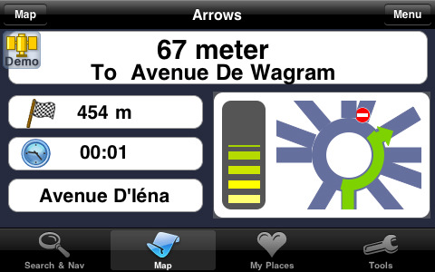
· Turn-by-turn voice guided navigation
· 2D and 3D (bird’s eye view) mapping navigation modes
· Arrows-only navigation mode (more visible AND saves on data usage)
· Navigation over satellite imagery including 3D ‘bird’s eye view’ mode
· Optional routing for car, pedestrian, truck, car pools, and more
· Routing setup tools: fastest,shortest, with traffic, etc.
· Navigation simulation mode to preview your route before you go
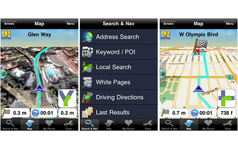
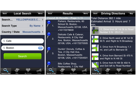
· Detailed driving directions with step-by-step text and graphics
SEARCH AND FIND:
· Easy address search for almost any place in the world
· POI / quick keywords search for most places around the world
· Local search from country-specific yellow pages directories (where available)
· Search white pages directories for people you need to get to (where available)
MAPS:
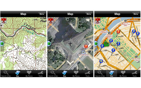
· Detailed street maps with floating street names for better visibility
· Easy map zooming and panning options
· Heads up or North up map orientation + high-performance map rotation
· High resolution satellite imagery in over 200 major cities worldwide
· Topographic maps covering the entire USA
· International map coverage including: All of North America (U.S., Canada and Mexico); Western Europe, Central Europe and most of Eastern Europe; Parts of Latin America (Brazil and Argentina); Israel and most of the Middle East; Parts of Asia (India, Thailand, Malaysia, Hong Kong, Taiwan, Singapore); Australia, New Zealand and South Africa. For details and updated coverage see the amAze GPS web site.
MULTI-LANGUAGE SUPPORT:
· Multiple language support for user interface and spoken voices
· Easy switching between languages
· Support for right-to-left languages (i.e. Arabic)
· Available languages: Arabic, Danish,Dutch, English, English (UK), Estonian, French, German, Greek, Hebrew, Italian, Polish, Portuguese (Portugal), Romanian, Russian, Spanish (Español) and Swedish.
FAVORITES:
· Fast saving of search results and entered destinations to Favorites list
· Automatic saving of last selected items to History list
What's New in This Release:
· support iOS 5, fixing bugs
What's New in 5.3:
· support IOS 5
What's New in 5.1.2:
· Bug Fixing.
· Support for OS 4.2
Like it? Share with your friends!
If you got an error while installing Themes, Software or Games, please, read FAQ.
Supported operating systems:
Apple iOS 10.x (iPad), Apple iOS 10.x (iPhone), Apple iOS 11.x (iPad), Apple iOS 12.x (iPad), Apple iOS 12.x (iPhone), Apple iOS 4.0.x (iPhone), Apple iOS 4.0.x (iPod Touch), Apple iOS 4.2.x (iPad), Apple iOS 4.2.x (iPhone), Apple iOS 4.2.x (iPod Touch), Apple iOS 4.3.x (iPad), Apple iOS 4.3.x (iPhone), Apple iOS 4.3.x (iPod Touch), Apple iOS 5.0 (iPad), Apple iOS 5.0 (iPhone), Apple iOS 5.0 (iPod Touch), Apple iOS 6.0 (iPad), Apple iOS 6.0 (iPhone), Apple iOS 6.0 (iPod Touch), Apple iOS 7.0 (iPad), Apple iOS 7.0 (iPhone), Apple iOS 7.0 (iPod Touch), Apple iOS 8.x (iPad), Apple iOS 8.x (iPhone), Apple iOS 8.x (iPod Touch), Apple iOS 9.x (iPad), Apple iOS 9.x (iPhone), Apple iOS 9.x (iPod Touch), Apple iPhone OS 3.1.x, Apple iPhone OS 3.1.x (iPod Touch), Apple iPhone OS 3.2.x (iPad)
Similar Software:
Nav4D Balkan Nav4D Balkan - Single intuitive menu gives the user all the information needed to begin a journey with confidence. Along the way take advantage of the automatic local and global search with rich contents.
Designed to attract everyone, the new interface concept makes usability and design a key point. Nav4D is the perfect navigation system for iPhone
Nav4D Saudi Arabia Nav4D Saudi Arabia - Single intuitive menu gives the user all the information needed to begin a journey with confidence. Along the way take advantage of the automatic local and global search with rich contents.
Designed to attract everyone, the new interface concept makes usability and design a key point. Nav4D is the perfect navigation system for iPhone
Grand Teton National Park - GPS Map Navigator Grand Teton National Park - GPS Map Navigator - Continues in the tradition of offering depth of information and functionality across expected places all over the world, exploring the map you get maximum details obtaining detailed information of each object on the map
Bregenz Map Offline Bregenz Map Offline - This will be perfect when you are traveling and you don't have internet connection. This Offline Maps is not a replacement of Google Maps. It is used when you don't have internet connection and want to use maps
Luxembourg City Map Offline Luxembourg City Map Offline - This will be perfect when you are traveling and you don't have internet connection. This Offline Maps is not a replacement of Google Maps. It is used when you don't have internet connection and want to use maps
Navmii GPS Live Spain Navmii GPS Live Spain - Navmii is a powerful GPS navigation solution for iOS devices. The app features turn-by-turn directions, voice guidance, automatic rerouting, live Google and Microsoft Bing Search, and more.
Navmii uses offline maps which are stored locally on the device, so there is no need for a data connection
Navfree GPS Live South Africa Navfree GPS Live South Africa - Navfree is a free GPS navigation solution for iOS devices. The app uses OpenStreetMap data, created and updated by thousands of users from all over the world.
The maps are stored locally on the device, so there is no need for a data connection
Ouachita National Forest - GPS Map Navigator Ouachita National Forest - GPS Map Navigator - Continues in the tradition of offering depth of information and functionality across expected places all over the world, exploring the map you get maximum details obtaining detailed information of each object on the map
Garmin UK & Ireland Garmin UK & Ireland - Download Garmin StreetPilot Onboard UK & Ireland and give your iPhone the best in GPS navigation... with free camera alerts, photoReal junction views, 3D buildings, and more
CoPilot Live Eastern Europe CoPilot Live Eastern Europe - Welcome to CoPilot Live, the multi-award winning turn-by-turn sat navigation app with digital street maps of Eastern Europe.
CoPilot Live is your personal travelling assistant, always ready to guide you to the door with voice directions. It can also keep you better informed with useful live information about your route
Other Software by developer «LocatioNet Systems Ltd.»:
amAze (LG) AmAze is a first of its kind free navigation and local search service. It is free to download and use and it contains wide coverage of maps including aerial photo in Europe, North America, Australia and parts of Asia and Africa
amAze (Samsung) AmAze is a first of its kind free navigation and local search service. It is free to download and use and it contains wide coverage of maps including aerial photo in Europe, North America, Australia and parts of Asia and Africa
amAze (Sony Ericsson) AmAze is a first of its kind free navigation and local search service. It is free to download and use and it contains wide coverage of maps including aerial photo in Europe, North America, Australia and parts of Asia and Africa
amAze (Motorola) AmAze is a first of its kind free navigation and local search service. It is free to download and use and it contains wide coverage of maps including aerial photo in Europe, North America, Australia and parts of Asia and Africa
amAze (Sanyo) First of its kind free navigation and local search service. It is free to download and use and it contains wide coverage of maps including aerial photo in Europe, North America, Australia and parts of Asia and Africa
amAze (Sonim) AmAze is a first of its kind free navigation and local search service. It is free to download and use and it contains wide coverage of maps including aerial photo in Europe, North America, Australia and parts of Asia and Africa
amAze (LG) AmAze is a first of its kind free navigation and local search service. It is free to download and use and it contains wide coverage of maps including aerial photo in Europe, North America, Australia and parts of Asia and Africa
amAze (Sony Ericsson) AmAze is a first of its kind free navigation and local search service. It is free to download and use and it contains wide coverage of maps including aerial photo in Europe, North America, Australia and parts of Asia and Africa
amAze (Motorola) AmAze is a first of its kind free navigation and local search service. It is free to download and use and it contains wide coverage of maps including aerial photo in Europe, North America, Australia and parts of Asia and Africa

")
")
")


")
")
")
")
")
")
")
")
")