Platforms: iPhone, iPad, iPod Touch, Apple iPhone OS
Categories: Science & Education
Upload date: 22 Oct 12
Developer: VITO Technology
License: Freeware
Downloads: 163
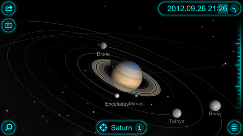
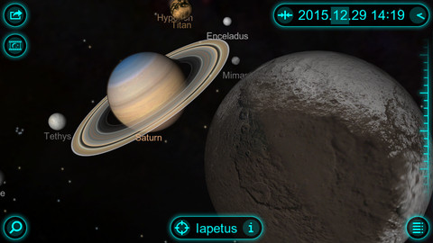
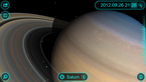
Solar Walk - Saturn - This app is a lite version of the popular astronomy software Solar Walk. It lets you explore Saturn, the sixth planet from the Sun, as well as its moons: Mimas, Enceladus, Tethys, Dione, Rhea, Titan, Hyperion, and Iapetus, in 3D.
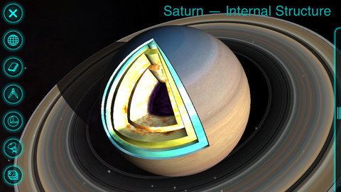
The application is packed with useful information, including size, mass, distance to the Sun, orbital velocity, internal structure, history of missions, and more. In addition, you can view beautiful images of each celestial body, as well as read the most interesting facts.
· GALAXY view - absolutely magical zoom out to view the whole galaxy option.
· TIME MACHINE - set any date you want including even minutes and take a travel through space and time.
· INFO - general info, its name, its mass, radius, distance to the sun, internal structure with the picture and science missions.
· MOONS - observe how many moons Saturn has and their track around the planet. Select one of the moons and learn.
· MIRRORING - wirelessly mirror the screen to an Apple TV 2.
· 3D MODE - to enjoy the view on 3D TV
Like it? Share with your friends!
If you got an error while installing Themes, Software or Games, please, read FAQ.
Supported operating systems:
Apple iOS 10.x (iPad), Apple iOS 10.x (iPhone), Apple iOS 11.x (iPad), Apple iOS 12.x (iPad), Apple iOS 12.x (iPhone), Apple iOS 4.3.x (iPad), Apple iOS 4.3.x (iPhone), Apple iOS 4.3.x (iPod Touch), Apple iOS 5.0 (iPad), Apple iOS 5.0 (iPhone), Apple iOS 5.0 (iPod Touch), Apple iOS 6.0 (iPad), Apple iOS 6.0 (iPhone), Apple iOS 6.0 (iPod Touch), Apple iOS 7.0 (iPad), Apple iOS 7.0 (iPhone), Apple iOS 7.0 (iPod Touch), Apple iOS 8.x (iPad), Apple iOS 8.x (iPhone), Apple iOS 8.x (iPod Touch), Apple iOS 9.x (iPad), Apple iOS 9.x (iPhone), Apple iOS 9.x (iPod Touch)
Similar Software:
SkySafari 3 Plus SkySafari 3 Plus - SkySafari Plus is a chart star app for all astronomy enthusiasts. It includes a comprehensive database of 2.5 million stars and 31,000 deep sky objects.
In addition, the application displays the Solar System's planets along with their moons, as well as 4,000 asteroids, comets and satellites
Star Walk for iPad Star Walk for iPad - Enjoy Global Astronomy Month 2010 (GAM 2010) together with Star Walk: observe the most important astronomical events, get to know everything about meteor showers, messier objects, stars, and constellations
Star Walk for iPhone Star Walk Indispensable for amateurs and professionals, as well as for kids who are eager to learn, Star Walk will guide you through the night sky in style
Space Images for iPad Space Images for iPad - Discover stunning images and videos of space, stars and planets -- including Earth and the sun! -- at your fingertips with the Space Images app from NASA's Jet Propulsion Laboratory, a leader in robotic exploration of the solar system
Astronomy - Oxford Dictionary Astronomy - Oxford Dictionary - Edited by renowned author and broadcaster Ian Ridpath, with the help of over 20 expert contributors, the second edition of this highly popular dictionary contains over 4,200 up-to-date entries on all aspects of astronomy
Solar Walk Solar Walk - Let's find out more about our neighboring planets in the Universe, play around with them determining the speed of circulation, time, choosing a particular planet to become the center of the Universe, seeing the moons of Saturn, Jupiter, Mars and Urano. The 3D model in the Solar Walk app is the exact reproduction of the real solar system
Mars Envi Mars Envi - It's the best way to review decades worth of Mars missions, and to check out the latest happenings there
Sky Above Sky Above - Sky Above is an iOS app which tells you where stars, constellations, planets and satellites are above you in the sky. The application also uses augmented reality to show the real sky using the device's camera. Just hold your iPhone or iPad up to the sky and the names of the sky objects will be overlayed on the camera display
HubbleSite HubbleSite, the online home of NASA’s Hubble Space Telescope, invites you to help choose the world’s most popular Hubble images. Get wallpapers, Hubble facts, and more.
Hubble’s vast collection of images awaits your critical and discerning eye
Other Software by developer «VITO Technology»:
Task2Gather Task2Gather is a unique Windows Mobile application for managing tasks and to-do’''s online. Besides it is a great collaborative tool that you can use on the go for accomplishing your tasks together with your family, friends or coworkers
VITO ButtonMapper ButtonMapper is a system application that allows creating custom commands for hardware buttons of your PocketPC
Map of Syria Map of Syria - A map of Syria, divided into 12 smaller territories for the ease of use. Good for intercity travels with SmartMap. Layers include:
Towns
Settlements
Airports
Roads
Railroads
Rivers
Inland water
Administrative borders
International borders
Trees
Map scale is 1:1 million
Map of Slovenia Map of Slovenia - A map of Slovenia. Good for intercity travels with SmartMap.
Layers include:
Towns
Settlements
Airports
Roads
Railroads
Rivers
Inland water
Administrative borders
International borders
Trees
Map scale is 1:1 million.
Good for use with any version of SmartMap. SmartMap can be purchased here
VITO RingtoneEditor VITO Ringtone Editor is the quickest way to create your own ringtones. All you need to do is listen to the melody and choose the part of it you want to assign as a ringtone. User-friendly intuitive interface simplifies the process greatly
Map of Nepal Map of Nepal - A map of Nepal. Good for intercity travels with SmartMap.
Layers include:
Towns
Settlements
Airports
Roads
Railroads
Rivers
Inland water
Administrative borders
International borders
Trees
Map scale is 1:1 million.
Good for use with any version of SmartMap. SmartMap can be purchased here
Map of Washington (US State) Map of Washington (US State) - A map of the Washington by VITO Technology. Good for intercity travels with SmartMap.
SmartMap is a mobile device application which uses vector and raster maps. It is compatible with any NMEA protocol GPS receiver (Compact Flash socket, serial port, BlueTooth or sleeve)
Map of Pakistan Map of Pakistan - A map of Pakistan. Good for intercity travels with SmartMap.
Layers include:
Towns
Settlements
Airports
Roads
Railroads
Rivers
Inland water
Administrative borders
International borders
Trees
Map scale is 1:1 million.
Good for use with any version of SmartMap. SmartMap can be purchased here
Map of Zimbabwe Map of Zimbabwe - A map of Zimbabwe. Good for intercity travels with SmartMap.
Layers include:
Towns
Settlements
Airports
Roads
Railroads
Rivers
Inland water
Administrative borders
International borders
Trees
Map scale is 1:1 million.
Good for use with any version of SmartMap. SmartMap can be purchased here
Map of North Dakota (US State) Map of North Dakota (US State) - A map of the North Dakota by VITO Technology. Good for intercity travels with SmartMap.
SmartMap is a mobile device application which uses vector and raster maps. It is compatible with any NMEA protocol GPS receiver (Compact Flash socket, serial port, BlueTooth or sleeve)

")


")


")