Platforms: iPhone, iPad, iPod Touch, Apple iPhone OS
Categories: Travel & Navigation
Upload date: 15 Oct 11
Developer: Visual IT
License: Commercial
Price: 2.99 $
Downloads: 25
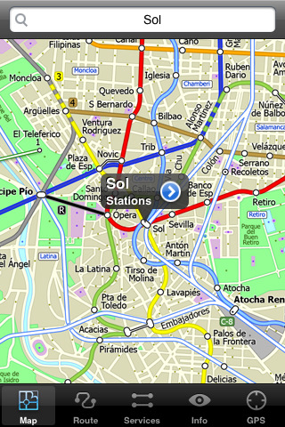
Madrid Metro by Zuti - The new Madrid Metro 10 map makes it easy to travel in and around the city using the the Metro, Renfe Rail and Metro Ligero Rail services. Unlike old fashioned schematic style maps this product contains a geographically accurate central area showing major streets, parks and places of interest etc, allowing the user to easily get their bearings.
MAP
The map is hand drawn by Visual IT and provides a unique geographically based view of Madrid with many places of interest drawn directly on the background so you can easily get your bearings when traveling around the city. You can also use your inbuilt GPS to accurately locate and track yourself within the city centre and see the nearest transportation stop and distance to it. This is the only pubic transportation route planner with this ability.
Tap on the map for location information, use the inbuilt search feature or choose from a list of locations. Places of interest, museums, hotels, parks, restaurant, shops, hospitals, streets, etc, are also included. The route planner will automatically suggest the nearest station to any place of interest you select.
MINUTE MAP
Another great feature is the “Minute Map” option which allows you to see the travel times from a start point to all other locations on the map. This is a unique way to view the topology of a city and gauge traveling times.
ROUTING
The application does not require an internet connection and will always be available to display a clear and detailed view of the city transport systems, plus list and animate the optimum route for your journey. This product provides the fastest route calculations of any mobile routing application (virtually instantaneous) using actual published journey times with the ability to select the quickest route or the route with the least changes.
· Full offline map and routing, no internet connection required.
· Colourful clear custom drawn geographically accurate mapping.
· Unique "Minute Map" feature allows quick view of all journey times from a start location.
· Services can be viewed on the map and turned on/off, routing around problems.
· Works on iPhone or iPod and in landscape or portrait mode.
· GPS location and tracking.
· Streets, Places of interest etc built into the application.
· Favourite routes can be stored and recalled.
· Access to live service information.
What's New in This Release:
· Support for retina display
· New "Measure Tool"
· Bug fix for iOS 5
What's New in 1.2:
· Added ability to view locations on a Google map.
· Icon colour change.
Like it? Share with your friends!
If you got an error while installing Themes, Software or Games, please, read FAQ.
Supported operating systems:
Apple iOS 10.x (iPad), Apple iOS 10.x (iPhone), Apple iOS 11.x (iPad), Apple iOS 12.x (iPad), Apple iOS 12.x (iPhone), Apple iOS 4.0.x (iPhone), Apple iOS 4.0.x (iPod Touch), Apple iOS 4.2.x (iPad), Apple iOS 4.2.x (iPhone), Apple iOS 4.2.x (iPod Touch), Apple iOS 4.3.x (iPad), Apple iOS 4.3.x (iPhone), Apple iOS 4.3.x (iPod Touch), Apple iOS 5.0 (iPad), Apple iOS 5.0 (iPhone), Apple iOS 5.0 (iPod Touch), Apple iOS 6.0 (iPad), Apple iOS 6.0 (iPhone), Apple iOS 6.0 (iPod Touch), Apple iOS 7.0 (iPad), Apple iOS 7.0 (iPhone), Apple iOS 7.0 (iPod Touch), Apple iOS 8.x (iPad), Apple iOS 8.x (iPhone), Apple iOS 8.x (iPod Touch), Apple iOS 9.x (iPad), Apple iOS 9.x (iPhone), Apple iOS 9.x (iPod Touch), Apple iPhone OS 3.1.x, Apple iPhone OS 3.1.x (iPod Touch), Apple iPhone OS 3.2.x (iPad)
Similar Software:
Chicago Metro by Zuti Chicago Metro by Zuti - Chicago Metro map makes it easy to travel in and around the city using the CTA rapid transport system, the commuter services of Metrarail, Northern Indiana Commuter Transportation District and also the Water Taxi services
Beijing Street Maps Beijing Street Maps - software that helps you download and store the travel maps and plans you need. This super-handy app lets you download publicly available maps and store them on your iPhone or iPod Touch. You can download the maps when you have fast wifi connection - and then use any time in the future without delay
Rome Metro for iPad by Zuti Rome Metro for iPad by Zuti - The Zuti Rome Metro application is a superb geographically based map and route planner for the Metro, Tram, Urban and Regional rail systems. Unlike old fashioned schematic style maps this product contains a geographically accurate central area showing major streets, parks and places of interest etc, allowing the user to easily get their bearings
Madrid Metro for iPad by Zuti Madrid Metro for iPad by Zuti - Madrid Metro map makes it easy to travel in and around the city using the the Metro, Renfe Rail and Metro Ligero Rail services. Unlike old fashioned schematic style maps this product contains a geographically accurate central area showing major streets, parks and places of interest etc, allowing the user to easily get their bearings
Great Britain Rail for iPad by Zuti Great Britain Rail for iPad by Zuti - The new Great Britain Rail map makes it easy to travel in and around the country using the rail services. This application contains a geographically accurate map of the whole of Great Britain allowing you to easily view the route of any journey
Minneapolis Maps Minneapolis Maps -software that helps you download and store the travel maps and plans you need. This super-handy app lets you download publicly available maps and store them on your iPhone or iPod Touch. You can download the maps when you have fast wifi connection - and then use any time in the future without delay
Packing Pro Packing Pro is a super-enhanced version of the popular, top-ranking Packing app
Up North! Grand Traverse Up North! Grand Traverse - Experience the many faces of the Grand Traverse region with this travel application from Sutro Media - Up North! Grand Traverse.
A Grand Traverse adventure can be a lot of things to different people. For some, Grand Traverse is a vast playground, ripe with opportunities for hiking and biking, camping and fishing, swimming and paddling
Plane Finder Free for iPhone Plane Finder Free for iPhone - Plane Finder Free is a flight tracker that shows real-time air traffic on a 2D map.
Tap on any plane to view flight number and plane registration / tail number.
The app can show the location of more than 12,000 aircraft, which are tracked in real-time using ADS-B data
Fuerth World Travel Fuerth World Travel - Map with locate me function makes you free to move.
Background reading always accompanies you on your trip
Other Software by developer «Visual IT»:
London Master A-Z for iPad London Master A-Z for iPad - This clear and colourful high quality map covers the same area as the market leading A-Z "Master Atlas of Greater London Street Atlas". The familiar look makes this by far the easiest London iPad map to use. The map is drawn by real cartographers with the detailed care and the human touch of emphasis and colour that A-Z are famous for
Tube 2 Portland (UIQ) Tube 2 Portland (UIQ) - This map package for Tube 2 consists of a fully scrollable detailed map of the Portland rail system.
Plan journeys on this system, list details of the quickest routes and see a superb animated display of your journey tracking around the system map
Tube 2 Madrid Pro (UIQ) Tube 2 Madrid Pro (UIQ) - This map package for Tube 2 consists of a fully scrollable detailed map of the Madrid metro system and linked street maps of central Madrid.
Plan journeys on the metro system, list details of the quickest routes and see a superb animated display of your journey tracking around the system map
London Congestion Charge Map (UIQ) London Congestion Charge Map (UIQ) - This map package is an essential addition to your Tube 2 maps if you drive in or around central London.
This reference map gives you a clear view of the area now covered by the congestion charge system, complete with a quick find utility to help you find any major road or street in and around the area
Tube 2 Munich (UIQ3) Tube 2 Munich (UIQ3) - This map package for Tube 2 consists of a fully scrollable detailed map of the Munich metro, rail & tram system.
Plan journeys on this system, list details of the quickest routes and see a superb animated display of your journey tracking around the system map.
Munich is the capital city of Bavaria, the southern most German federal state
Tube 2 Chicago (Palm OS) Tube 2 Chicago (Palm OS) - This map package for Tube 2 consists of a fully scrollable detailed map of the Chicago metro & commuter rail system.
It includes the rapid transport system of subway and elevated lines, in addition to the many commuter rail lines. The map also indicates how the Amtrak intercity routes intersect with the cities transport network
Tube 2 Atlanta (UIQ) Tube 2 Atlanta (UIQ) - This map package for Tube 2 consists of a fully scrollable detailed map of the Atlanta rail system.
Plan journeys on this system, list details of the quickest routes and see a superb animated display of your journey tracking around the system map
TUBE 2 Engine Palm Transform your PDA into a fully scrollable detailed map of one of the worlds subway or metro systems
Tube Hong Kong (Series 60) Tube Hong Kong (Series 60) - Our highly acclaimed Tube application that guides you around the subway system of Hong Kong is now available for your Series 60 Symbian powered phone. An essential addition to your phone for locals and tourists alike.
· A detailed clear colour map of the transport system fully scrollable.
· Quick find station utility
Tube 2 Munich (UIQ) Tube 2 Munich (UIQ) - This map package for Tube 2 consists of a fully scrollable detailed map of the Munich metro, rail & tram system.
Plan journeys on this system, list details of the quickest routes and see a superb animated display of your journey tracking around the system map.
Munich is the capital city of Bavaria, the southern most German federal state

")


")
")
")
")
")
")

")
")