Platforms: iPhone, iPad, iPod Touch, Apple iPhone OS
Categories: Travel & Navigation
Upload date: 18 Aug 14
Developer: Garmin
License: Commercial
Price: 64.99 $
Downloads: 111
Garmin UK & Ireland - Download Garmin StreetPilot Onboard UK & Ireland and give your iPhone the best in GPS navigation... with free camera alerts, photoReal junction views, 3D buildings, and more.
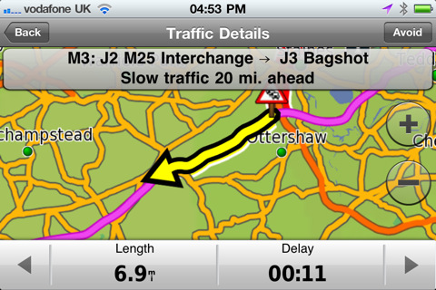
Garmin StreetPilot with UK and Ireland maps is packed full of the great Garmin navigation features found in our award-winning navigators and includes free access to real-time speed camera updates, with no monthly subscription costs, and is the first iPhone navigation application to include photoReal images of complex junctions, to help you navigate with confidence. Detailed 3D buildings also help you get a clear understanding of your journey surroundings. For the ultimate navigation experience upgrade to Garmin's new advanced traffic service - 3D Traffic Live.
Map coverage:
Features detailed maps for Great Britain, the Isle of Man, the Channel Islands, and major cities in Northern Ireland and the Republic of Ireland.
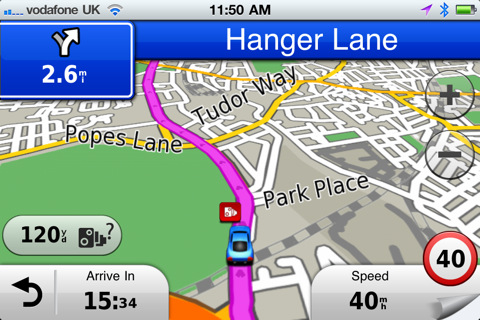
· Free Speedwatch Safety Cameras - Massive database of fixed and mobile cameras regularly updated and with no additional monthly subscription
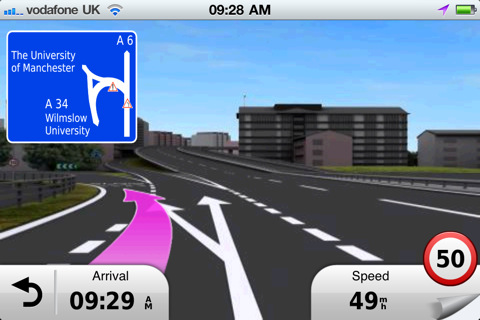
· photoReal Junction View - Helps you to navigate tricky junctions with confidence
· 3D Traffic Live (in-app upsell) - Garmin's newest and best traffic service, updated three times a minute to avoid delays on your journey
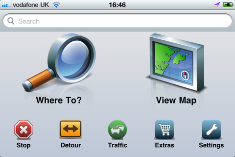
· Google Local Search - Need a location? Search for it on Google and navigate to it
· Text-to-speech- Voice-prompted, turn-by-turn directions including street names
· Lane Assist -Illustrates the correct lane choice for upcoming turns and exits
· 3D Buildings - Superb 3D imaging shows you a realistic view of your surroundings, with super fast redraw speeds
· Points of Interest - Use the quick search bar to find local points of interest, and let Garmin do the rest
· Trip Computer - Vital journey statistics including next turn, ETA and maximum speed
· Exit Services - Check motorway junctions along your route for useful POI's like fuel, accommodations, and toilets
· Advanced Trip Planner - Plan a journey with multiple stops and let Garmin StreetPilot automatically sort the order of destinations
· Address book integration - Easily navigate to all your contacts
· Where Am I? - Emergency locator shows your exact latitude and longitude coordinates, the nearest address and intersection, and the closest hospitals, police stations and fuel stations
What's New in This Release:
· Enhanced Urban Guidance functionality: We expanded the coverage of our public transport navigation to more cities and metropolitan areas. In addition to that you have now the choice of up to three different routing alternatives.
· Latest map data
· Various stability improvements and bug fixes.
What's New in 2.5.1:
· Users can now choose from many different map themes.
· Various stability improvements and bug fixes.
What's New in 2.4.2:
· Improved Bluetooth audio streaming
· Resolves an issue which required to have an internet connection when starting the app in certain cases
· Minor bug fixes and enhancements
What's New in 2.2:
· iOS 6 and iPhone 5 support
· URBAN GUIDANCE considers public transportation options, such as subways, trams, buses and water taxis, when calculating pedestrian routes. You will be guided to a transit stop by foot and you're able to look up detailed information on what line to take and where to get off. The feature is available through In App Purchase.
· PANORAMA VIEW 3D provides true 3D elevation views obtained from NASA's height and terrain data enable intuitive orientation and show users what lies ahead. Panorama View 3D is available through In App Purchase.
· GOOGLE STREET VIEW provides users a street-level view of their destination before starting a route and shortly before arriving. Users can also look at a full-screen 360° view to get a better understanding of their destination's surroundings. The feature is available in cities with Google Street View coverage.
What's New in 2.1:
· New Map Layers feature allows users to create a unique navigation and map browsing experience by selecting the details they want to see on the map
· Traffic Notifications make it even easier to avoid incidents by highlighting events specifically on your route
· Updated NAVTEQ maps
What's New in 2.0:
· photoLive traffic cameras allow you to keep an eye on traffic conditions along your route with live photographic images of the road ahead (available via in-app purchase)
· Weather feature shows current weather conditions and a five-day forecast at your current location or destination
· Share locations via Facebook or SMS with friends
· All new NAVTEQ map data
Like it? Share with your friends!
If you got an error while installing Themes, Software or Games, please, read FAQ.
Supported operating systems:
Apple iOS 10.x (iPad), Apple iOS 10.x (iPhone), Apple iOS 11.x (iPad), Apple iOS 12.x (iPad), Apple iOS 12.x (iPhone), Apple iOS 4.0.x (iPhone), Apple iOS 4.0.x (iPod Touch), Apple iOS 4.2.x (iPad), Apple iOS 4.2.x (iPhone), Apple iOS 4.2.x (iPod Touch), Apple iOS 4.3.x (iPad), Apple iOS 4.3.x (iPhone), Apple iOS 4.3.x (iPod Touch), Apple iOS 5.0 (iPad), Apple iOS 5.0 (iPhone), Apple iOS 5.0 (iPod Touch), Apple iOS 6.0 (iPad), Apple iOS 6.0 (iPhone), Apple iOS 6.0 (iPod Touch), Apple iOS 7.0 (iPad), Apple iOS 7.0 (iPhone), Apple iOS 7.0 (iPod Touch), Apple iOS 8.x (iPad), Apple iOS 8.x (iPhone), Apple iOS 8.x (iPod Touch), Apple iOS 9.x (iPad), Apple iOS 9.x (iPhone), Apple iOS 9.x (iPod Touch)
Similar Software:
Marine: Coral Sea - GPS Map Navigator Marine: Coral Sea - GPS Map Navigator - FlytoMap provides complete, quick and easy to use map applications for navigation for iPhone. Continues in the tradition of offering depth of information and functionality across expected places all over the world, exploring the map you get maximum details obtaining detailed information of every object on the map
Cabela's Recon Hunt Cabela's Recon Hunt is the first mobile navigation application built solely for hunters. With Recon Hunt, you can find hunting spots on detailed maps, track wildlife, take trophy photos and backtrack home. Recon Hunt also tracks other essentials as well: weather forecasts, sun and moon phases, trip stats and ballistics information
Ndrive Spain Ndrive Spain - This app will turn your iPhone into a turn by turn voice navigation device.
WHAT YOU ARE BUYING
You are buying a lifetime license of the latest maps. There are no monthly fees or hidden charges.
No data plan is needed to run NDrive software and even when your phone is in roaming, your GPS Navigation from NDrive will run smoothly and uninterupted
Nav4D Portugal (LOW COST) Nav4D Portugal (LOW COST) - The first **low cost** application!
Don't waste your money!
Why pay for lifetime if you only need it for a limited time??
Nav4D is highly innovative at a very low price.
Nav4D is a high-end GPS navigator. It brings a new look to users mobility interaction. Turn by turn directions
GeoInfo GeoInfo gives you all the useful information about your position and location in a user-friendly environment.
Swiss coordinates:
· Display the Swiss coordinates in the X-and Y-axis.
International co-ordinates:
· Display coordinates with the International Latitude and Longitude. Formatted and Decimal.
Speed:
· Display Km / h maximum speed inc
CoPilot Live UK & Ireland CoPilot Live UK & Ireland - CoPilot Live turns your iPhone into a full-featured in-car sat navigation system. It's complete with premium quality UK and Ireland street maps, full 7 digit UK post codes and turn-by-turn voice directions right to the door
Sygic Southeast Asia: GPS Navigation Sygic Southeast Asia: GPS Navigation - Sygic is a voice guided GPS navigation application. It's packed with TomTom maps and a robust set of navigation features. Both app and maps are updated for free. Maps are stored on the phone for offline use
Luxembourg City Map Offline Luxembourg City Map Offline - This will be perfect when you are traveling and you don't have internet connection. This Offline Maps is not a replacement of Google Maps. It is used when you don't have internet connection and want to use maps
San Antonio Driving Tours This revolutionary application presents you several driving tours designed to show you the best of the city, as it comes with detailed tour route maps and powerful navigation features to guide you from one sight to the next
Linz Map Offline Linz Map Offline - This will be perfect when you are traveling and you don't have internet connection. This Offline Maps is not a replacement of Google Maps. It is used when you don't have internet connection and want to use maps
Other Software by developer «Garmin»:
Garmin Tracker (iPhone) Garmin Tracker (iPhone) - Brought to you by the worldwide leader in GPS, Garmin Tracker — combined with a GPS-enabled Garmin tracking device (purchase required) — lets you track what’s important while on the go.
Garmin Tracker is a free, unique application that'll help keep tabs on whatever's important to you
Garmin SG/MY Garmin SG/MY - Garmin StreetPilot is a powerful GPS navigation solution for iOS devices. It comes preloaded with the latest maps of Singapore, Malaysia and Brunei.
Garmin Street offers many useful features, such as turn-by-turn directions, photo-realistic junction views, 3D buildings, exit services, speed cameras, and more
Garmin Western Europe Download Garmin StreetPilot Western Europe and give your iPhone or iPad the best in GPS navigation with free safety camera alerts, photoReal junction views, 3D buildings and more
Garmin Mobile for BlackBerry Garmin Mobile for BlackBerry - Turn your BlackBerry into a savvy navigator with Garmin Mobile. Includes everything you need - maps, millions of POIs and easy-to-use navigation software.
Get Premium Map Data
With spoken turn-by-turn directions that speak street names and millions of points of interest (POIs), Garmin Mobile puts robust content right at your fingertips
OpenCaching (Android) OpenCaching (Android) is the official geocaching app for OpenCaching.com, a geocaching community powered by the user, for the user. With this app, you get the full OpenCaching.com experience right in the palm of your hands. Easily find, hide, log and share caches right from your Android device
Garmin Indonesia Garmin Indonesia - Garmin StreetPilot is a powerful GPS navigation solution for iOS devices. It comes preloaded with the latest map of Indonesia.
Garmin Street offers many useful features, such as turn-by-turn directions, photo-realistic junction views, 3D buildings, exit services, speed cameras, and more
Garmin GDL 39 Utility Garmin GDL 39 Utility - Garmin GDL 39 Utility is a companion app for the GDL 39 Portable ADS-B Receiver. It allows you to update your GDL 39 firmware using your iOS device.
The application also shows the signal strength, ground station status and battery life of GDL 39. In addition, it includes a navigation panel, which displays altimeter, heading and ground speed
Whereis Navigator Whereis Navigator turns your Telstra Android device into an easy to use & full-featured GPS navigation unit, powered by Garmin and available for use in Australia only
Garmin U.S.A. Garmin U.S.A. - Download Garmin StreetPilot Onboard U.S.A. and give your iPhone the best in GPS navigation...even when you don’t have cell coverage. Maps reside on your device, so you can look up addresses and millions of points-of-interest such as gas stations, restaurants and ATMs without needing wireless coverage
Garmin Fit Garmin Fit - Turn your iPhone into a powerful training tool with the Garmin Fit application. See your current walking, running or cycling stats at one glance, or review and share them later thanks to automatic uploading to Garmin Connect. It even allows you select the perfect soundtrack for your workout


")


")


