Platforms: iPhone, iPad, iPod Touch, Apple iPhone OS
Categories: System Utilities, Travel & Navigation
Upload date: 21 Jun 12
Developer: Dirk Stichling
License: Freeware
Downloads: 307
myTracks is not yet another GPS tracking app, but the perfect supplement for the desktop edition of myTracks for Mac OS X. GPS tracks can be recorded with both iPhone or iPod Touch and easily synchronized with your Mac. On the Mac the tracks can be organized comfortably and linked with photos of your digital camera (Geotagging). Afterwards you can download your desktop track library including the photos onto your iPhone. Now you can take all of your tracks including your photos with you all the time.
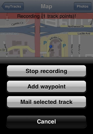
· Recording of GPS tracks with iPhone or iPod Touch
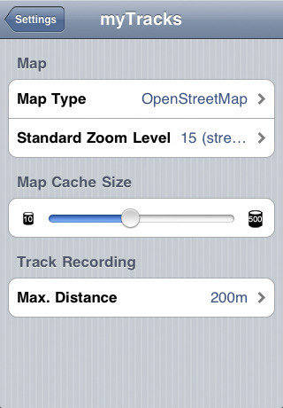
· Presentation of the tracks on maps by OpenStreetMap or Bing Maps
· The OpenStreetMap can be used offline. You don't need an active internet connection.
· Creation of waypoints
· Tracks can be sent by e-mail
· Bookmarks
· Recorded tracks can be synchronized with your Mac easily.
· The tracks organized on your Mac can by loaded to your iPhone. If the tracks have linked photos downscaled versions of the photos are copied to the iPhone.
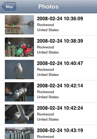
· The positions of the photos are shown on the map
· Fullscreen navigator for the photos
· Photos can be sent by e-mail
What's New in This Release:
· New map implementation with seamless zooming and smooth scrolling.
What's New in 1.6.0:
· Optimized for retina display.
· New map type: "OpenStreetMap Big" with extra big fonts.
· The current speed and direction is shown.
What's New in 1.5.1:
· New Map: OpenPisteMap
· Minor improvements and bug fixes
What's New in 1.4.0:
· New first view for easier navigation
· Recovery mode for recorded tracks in case the App gets killed
· minor Bugfixe
Like it? Share with your friends!
If you got an error while installing Themes, Software or Games, please, read FAQ.
Supported operating systems:
Apple iOS 10.x (iPad), Apple iOS 10.x (iPhone), Apple iOS 11.x (iPad), Apple iOS 12.x (iPad), Apple iOS 12.x (iPhone), Apple iOS 4.0.x (iPhone), Apple iOS 4.0.x (iPod Touch), Apple iOS 4.2.x (iPad), Apple iOS 4.2.x (iPhone), Apple iOS 4.2.x (iPod Touch), Apple iOS 4.3.x (iPad), Apple iOS 4.3.x (iPhone), Apple iOS 4.3.x (iPod Touch), Apple iOS 5.0 (iPad), Apple iOS 5.0 (iPhone), Apple iOS 5.0 (iPod Touch), Apple iOS 6.0 (iPad), Apple iOS 6.0 (iPhone), Apple iOS 6.0 (iPod Touch), Apple iOS 7.0 (iPad), Apple iOS 7.0 (iPhone), Apple iOS 7.0 (iPod Touch), Apple iOS 8.x (iPad), Apple iOS 8.x (iPhone), Apple iOS 8.x (iPod Touch), Apple iOS 9.x (iPad), Apple iOS 9.x (iPhone), Apple iOS 9.x (iPod Touch), Apple iPhone OS 3.1.x, Apple iPhone OS 3.1.x (iPod Touch), Apple iPhone OS 3.2.x (iPad)
Similar Software:
Majella National Park - GPS Map Navigator Majella National Park - GPS Map Navigator - FlytoMap provides complete, quick and easy to use map applications for navigation for iPhone. Continues in the tradition of offering depth of information and functionality across expected places all over the world, exploring the map you get maximum details obtaining detailed information of every object on the map
Sygic Gulf Countries: GPS Navigation Sygic Gulf Countries: GPS Navigation - Sygic Mobile Maps is the most complete turn-by-turn, voice guided navigation software for your mobile phone.
· All maps with you on your phone - Bahrain, Kuwait, Oman, Qatar, Saudi Arabia and United Arab Emirates from TomTom.
· Free map updates.
· Speed camera crowd-sourcing protects your wallet
Marine: South West England - GPS Map Navigator Marine: South West England - GPS Map Navigator - FlytoMap provides complete, quick and easy to use map applications for navigation for iPhone. Continues in the tradition of offering depth of information and functionality across expected places all over the world, exploring the map you get maximum details obtaining detailed information of every object on the map
Navmii GPS Live Sweden Navmii GPS Live Sweden - Navmii is a powerful GPS navigation solution for iOS devices. The app features turn-by-turn directions, voice guidance, automatic rerouting, live Google and Microsoft Bing Search, and more.
Navmii uses offline maps which are stored locally on the device, so there is no need for a data connection
Rome GPS Guide The only thing we do, help you to move freely as an alien, by "Offline" & "GPS"
Nav4D Alaska Nav4D Alaska - Single intuitive menu gives the user all the information needed to begin a journey with confidence. Along the way take advantage of the automatic local and global search with rich contents.
Designed to attract everyone, the new interface concept makes usability and design a key point. Nav4D is the perfect navigation system for iPhone
Malmo Map Offline Malmo Map Offline - This will be perfect when you are traveling and you don't have internet connection. This Offline Maps is not a replacement of Google Maps. It is used when you don't have internet connection and want to use maps
Magellan RoadMate USA Transform your iPhone or iPod touch into an easy-to-use GPS navigator with real-time traffic alerts included!
Worcester (MA, USA) Map Offline Worcester (MA, USA) Map Offline - This will be perfect when you are traveling and you don't have internet connection. This Offline Maps is not a replacement of Google Maps. It is used when you don't have internet connection and want to use maps
Cuyahoga Valley National Park - GPS Map Navigator Cuyahoga Valley National Park - GPS Map Navigator - Continues in the tradition of offering depth of information and functionality across expected places all over the world, exploring the map you get maximum details obtaining detailed information of each object on the map
Other Software by developer «Dirk Stichling»:
GeoMaps GeoMaps provides a whole bunch of different maps for your iPad. Most of the maps are cached so that you can use them offline. It is even possible to download maps for a complete region for offline usage. GeoMaps is the perfect addition to the Map App already installed on your iPad


 Map Offline")

