Platforms: iPhone, iPad, iPod Touch, Apple iPhone OS
Categories: Travel & Navigation
Upload date: 15 Oct 12
Developer: Flytomap
License: Commercial
Price: 1.99 $
Downloads: 25
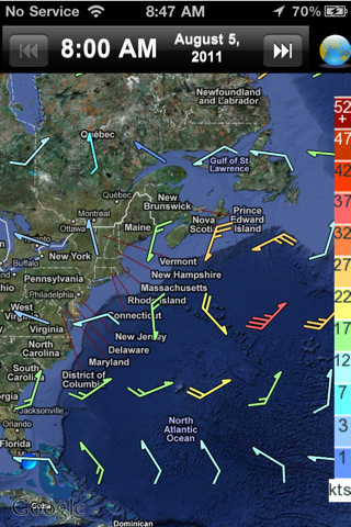
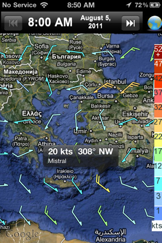
Wind NOAA - realWind provides you with a wind forecast for any locations on Earth!
For kitesurfers, windsurfers, surfers, sailors, and paragliders:
· The real time observations, so you know what's going on!
· And accurate forecasts, so you can always find the best conditions for your sport!
No need to figure out your Lat, Long or Zip Code. Your iPhone or iPod Touch figures it out for you.
Try it, you will love this app and its features!
What's New in This Release:
· Flytomap layer available with marine charts data on line
· Search of names by genomes service
· Function for centering the view on GPS position
Like it? Share with your friends!
If you got an error while installing Themes, Software or Games, please, read FAQ.
Supported operating systems:
Apple iOS 10.x (iPad), Apple iOS 10.x (iPhone), Apple iOS 11.x (iPad), Apple iOS 12.x (iPad), Apple iOS 12.x (iPhone), Apple iOS 4.0.x (iPhone), Apple iOS 4.0.x (iPod Touch), Apple iOS 4.2.x (iPad), Apple iOS 4.2.x (iPhone), Apple iOS 4.2.x (iPod Touch), Apple iOS 4.3.x (iPad), Apple iOS 4.3.x (iPhone), Apple iOS 4.3.x (iPod Touch), Apple iOS 5.0 (iPad), Apple iOS 5.0 (iPhone), Apple iOS 5.0 (iPod Touch), Apple iOS 6.0 (iPad), Apple iOS 6.0 (iPhone), Apple iOS 6.0 (iPod Touch), Apple iOS 7.0 (iPad), Apple iOS 7.0 (iPhone), Apple iOS 7.0 (iPod Touch), Apple iOS 8.x (iPad), Apple iOS 8.x (iPhone), Apple iOS 8.x (iPod Touch), Apple iOS 9.x (iPad), Apple iOS 9.x (iPhone), Apple iOS 9.x (iPod Touch)
Similar Software:
Earth-Now Earth-Now - NASA's Earth Now is an app that visualizes recent global climate data from Earth Science satellites, including surface air temperature, carbon dioxide, carbon monoxide, ozone, and water vapor as well as gravity and sea level variations. Data sets are visually described using "false color" maps
Sunset & Sunrise calculator Sunset & Sunrise calculator - SUNSET displays time for dawn, sunrise, sunset and night anywhere in the world. Three ways are provided to choose the location :
1) Press "Here" in order to get the iPhone localization
2) Enter the Latitude and Longitude of the place you want to know the sun hours.
3) Select a city between more than 4000 cities in the world
FlightTrack FlightTrack - The best flight tracking app out there. Track every aspect of your domestic and international flights with real-time updates and beautiful, zoomable maps. Check gate numbers, delays and cancellations
Charlotte(North Carolina) World Travel Charlotte(North Carolina) World Travel - Map with locate me function makes you free to move.
Background reading always accompanies you on your trip
WthrDial WthrDial - WTHR is a simple and beautiful weather app for iPhone. Built on Dieter Rams' 10 principles of design, WTHR gives you weather information at a glance, without complicated weather radars or atmospheric pressure readings. WTHR lets you spend more time enjoying the weather rather than watching it
Hong Kong Map and Walking Tours Hong Kong Map and Walking Tours - No need to hop on a tour bus or join a group; now you can explore all the best attractions on your own, at your own pace, and at a cost that is only a fraction of what you would normally pay for a guided tour
The Weather Channel Max (iPhone) The Weather Channel Max (iPhone) - The Weather Channel Max delivers the weather tools you need to plan your day, week or even the next hour. Using patented ultra-local TruPoint weather technology, The Weather Channel is the only weather provider to provide future radar, so you'll know where the storm is heading, not just where it's been
eWeather HD (iPhone/iPad) eWeather HD (iPhone/iPad) - The key point of Elecont Weather is a unique combination of innovative design and the professional quality of weather forecasting. The conception of placing weather data on the clock face is very easy for reading and understanding and helps you to plan your outdoor activities considering weather forecast with hour accuracy
AccuWeather for iPhone AccuWeather for iPhone - Plan your day with local forecasts from the most trusted name in weather! From what to wear to how to travel, AccuWeather for iPhone gives you fast, easy access to current weather information so you can make your plans with confidence
RadarScope (iPhone/iPad) RadarScope (iPhone/iPad) is a specialized display utility for weather enthusiasts that allows you view NEXRAD Level 3 radar data. It can display the latest reflectivity, velocity, and other products from any NEXRAD radar site in the lower 48 United States and Puerto Rico
Other Software by developer «Flytomap»:
Rhodes Island - GPS Map Navigator Rhodes Island - GPS Map Navigator - FlytoMap provides complete, quick and easy to use map applications for navigation. Continues in the tradition of offering depth of information and functionality across expected places all over the world, exploring the map you get maximum details obtaining detailed information of every object on the map
Cozumel Island - GPS Map Navigator Cozumel Island - GPS Map Navigator - FlytoMap provides complete, quick and easy to use map applications for navigation for iPhone. Continues in the tradition of offering depth of information and functionality across expected places all over the world, exploring the map you get maximum details obtaining detailed information of every object on the map
Catoctin Mountain Park - Standard Catoctin Mountain Park - Standard - Continues in the tradition of offering depth of information and functionality across expected places all over the world, exploring the map you get maximum details obtaining detailed information of each object on the map
Cozumel Island HD - GPS Map Navigator Cozumel Island HD - GPS Map Navigator - FlytoMap provides complete, quick and easy to use map applications for navigation for iPad. Continues in the tradition of offering depth of information and functionality across expected places all over the world, exploring the map you get maximum details obtaining detailed information of every object on the map
New Forest National Park - GPS Map Navigator New Forest National Park - GPS Map Navigator - FlytoMap provides complete, quick and easy to use map applications for navigation for iPhone. Continues in the tradition of offering depth of information and functionality across expected places all over the world, exploring the map you get maximum details obtaining detailed information of every object on the map
Marine: Melbourne HD - GPS Map Navigator Marine: Melbourne HD - GPS Map Navigator - FlytoMap provides complete, quick and easy to use map applications for navigation for iPad. Continues in the tradition of offering depth of information and functionality across expected places all over the world, exploring the map you get maximum details obtaining detailed information of every object on the map
Congaree Swamp National Monument - GPS Map Navigator Congaree Swamp National Monument - GPS Map Navigator - Continues in the tradition of offering depth of information and functionality across expected places all over the world, exploring the map you get maximum details obtaining detailed information of each object on the map
Ocala National Forest - GPS Map Navigator Ocala National Forest - GPS Map Navigator - FlytoMap provides complete, quick and easy to use map applications for navigation for iPhone. Continues in the tradition of offering depth of information and functionality across expected places all over the world, exploring the map you get maximum details obtaining detailed information of every object on the map
Lakes: Michigan - GPS Map Navigator Lakes: Michigan - GPS Map Navigator - Continues in the tradition of offering depth of information and functionality across expected places all over the world, exploring the map you get maximum details obtaining detailed information of each object on the map
Hainich National Park - GPS Map Navigator Hainich National Park - flytoMap provides complete, quick and easy to use map applications for navigation for iPhone. Continues in the tradition of offering depth of information and functionality across expected places all over the world, exploring the map you get maximum details obtaining detailed information of every object on the map


 World Travel")


")
")

")


