Platforms: iPhone, iPad, iPod Touch, Apple iPhone OS
Categories: Travel & Navigation
Upload date: 15 Oct 12
Developer: Garmin
License: Commercial
Price: 39.99 $
Downloads: 64
Garmin U.S.A. - Download Garmin StreetPilot Onboard U.S.A. and give your iPhone the best in GPS navigation...even when you don’t have cell coverage. Maps reside on your device, so you can look up addresses and millions of points-of-interest such as gas stations, restaurants and ATMs without needing wireless coverage. It’s as close to having a Garmin nüvi personal navigator as an iPhone or iPad can get.
Designed exclusively for your iPhone by Garmin, the world leader in GPS navigation. The Garmin StreetPilot Onboard application turns your iOS device into a premium GPS navigator with turn-by-turn voice-prompted directions that speaks street names and automatically calculates a new route if you get off track. Garmin onboard navigation offers rich mapping and many advanced features, but is still simple and intuitive to use. It includes Google Local Search in addition to several million preloaded points of interest, and also includes red-light and speed cameras powered by Speedwatch.
Map coverage:
United States (excluding Alaska), Plus Puerto Rico, U.S. Virgin Islands, Cayman Islands, The Bahamas, French Guiana, Guadeloupe, Martinique, Saint Barthélemy
· Intuitive user interface
· Maps for the U.S. installed on your device (Lower 49 states)
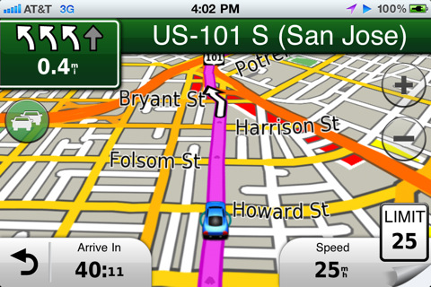
· Voice-prompted, turn-by-turn directions including street names
· Millions of preloaded points of interest including gas stations, restaurants and ATMs, along with quick-search shortcuts to access your most common search terms
· Integrated Google Local Search
· Place calls directly from search listings
· 3-D buildings and landmarks
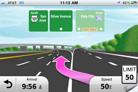
· Lane assist with junction view provides a photorealistic illustration of the correct lane for different maneuvers
· Integrated Speedwatch red-light and speed cameras (as available) including user-generated alerts
· Via points to enable interim stops along a route
· Detour feature for quickly calculating an alternate route
· Speed limits with alerts for most major roads
· Where Am I? emergency locator shows your exact latitude and longitude, the nearest address and intersection, and the closest hospitals, police stations and gas stations
· Exit Services allow you to quickly see services such as restaurants, gas stations, and lodging available at exits along your route
· Trip planner for creating a route with multiple stops in advance with automatic or manual ordering of destinations
· Address book integration so you can easily navigate to contacts
· Configurable vehicle icons to customize what appears on the moving map
· Configurable map data field to show arrival time, time or distance to destination, direction of travel, elevation and more
· Route overview, turns list and turn-by-turn detail available to help keep you on track
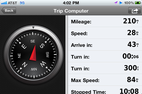
· Trip computer includes a compass heading and bearing indicator, resettable odometer trip statistics such as arrival distance, next turn time and distance, average moving speed, maximum speed, total trip time, etc.
· Trip Log enables an electronic breadcrumb trail that shows you where you've been
· Super fast map drawing and panning
· GPS navigation even when there is no cell coverage available
· Continuous navigation during an active call
· Navigate in both portrait and landscape mode
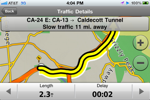
· Real-time traffic information and fuel pricing are available as optional services
What's New in This Release:
· iOS 6 and iPhone 5 support
· URBAN GUIDANCE considers public transportation options, such as subways, trams, buses and water taxis, when calculating pedestrian routes. You will be guided to a transit stop by foot and you're able to look up detailed information on what line to take and where to get off. The feature is available through In App Purchase.
· PANORAMA VIEW 3D provides true 3D elevation views obtained from NASA's height and terrain data enable intuitive orientation and show users what lies ahead. Panorama View 3D is available through In App Purchase.
· GOOGLE STREET VIEW provides users a street-level view of their destination before starting a route and shortly before arriving. Users can also look at a full-screen 360° view to get a better understanding of their destination's surroundings. The feature is available in cities with Google Street View coverage.
What's New in 2.1:
· New Map Layers feature allows users to create a unique navigation and map browsing experience by selecting the details they want to see on the map
· Traffic Notifications make it even easier to avoid incidents by highlighting events specifically on your route
· Updated NAVTEQ maps
What's New in 2.0:
· photoLive Traffic cameras allow you to keep an eye on traffic conditions along your route with live photographic images of the road ahead (available via in-app purchase)
· Weather feature shows current weather conditions and a 5 day forecast at your current location or destination
· Share locations via Facebook or SMS with friends
· All new NAVTEQ map data
Like it? Share with your friends!
If you got an error while installing Themes, Software or Games, please, read FAQ.
Supported operating systems:
Apple iOS 10.x (iPad), Apple iOS 10.x (iPhone), Apple iOS 11.x (iPad), Apple iOS 12.x (iPad), Apple iOS 12.x (iPhone), Apple iOS 4.0.x (iPhone), Apple iOS 4.0.x (iPod Touch), Apple iOS 4.2.x (iPad), Apple iOS 4.2.x (iPhone), Apple iOS 4.2.x (iPod Touch), Apple iOS 4.3.x (iPad), Apple iOS 4.3.x (iPhone), Apple iOS 4.3.x (iPod Touch), Apple iOS 5.0 (iPad), Apple iOS 5.0 (iPhone), Apple iOS 5.0 (iPod Touch), Apple iOS 6.0 (iPad), Apple iOS 6.0 (iPhone), Apple iOS 6.0 (iPod Touch), Apple iOS 7.0 (iPad), Apple iOS 7.0 (iPhone), Apple iOS 7.0 (iPod Touch), Apple iOS 8.x (iPad), Apple iOS 8.x (iPhone), Apple iOS 8.x (iPod Touch), Apple iOS 9.x (iPad), Apple iOS 9.x (iPhone), Apple iOS 9.x (iPod Touch)
Similar Software:
Scout by Telenav for iPhone Scout by Telenav for iPhone - Scout is a powerful GPS navigation solution for iOS devices. The app can quickly guide you to your chosen destination with spoken turn-by-turn directions.
In addition, Scout allows you to easily find points of interest around you, access traffic information, view commute times, and more
MotionX GPS MotionX-GPS is for your outdoor life:
That's Walking, Hiking, Running, Cycling, Biking, Sailing, Skiing, Flying, Racing, Geocaching.
MotionX-GPS shows your position and track at all times on street, topo/terrain and satellite maps
NAVIGON Iberia NAVIGON Iberia - With the NAVIGON MobileNavigator you can transform your iPhone into a fully functional mobile navigation system that is every bit as good as the multi-award-winning personal navigation devices from NAVIGON in terms of its user-friendliness and features
Dearborn(Michigan) World Travel Dearborn(Michigan) World Travel - Map with locate me function makes you free to move.
Background reading always accompanies you on your trip
Navmii GPS Live UK Navmii GPS Live UK - Navmii is a powerful GPS navigation solution for iOS devices. The app features turn-by-turn directions, voice guidance, automatic rerouting, live Google and Microsoft Bing Search, and more.
Navmii uses offline maps which are stored locally on the device, so there is no need for a data connection
Navmii GPS Live Netherlands Navmii GPS Live Netherlands - Navmii is a powerful GPS navigation solution for iOS devices. The app features turn-by-turn directions, voice guidance, automatic rerouting, live Google and Microsoft Bing Search, and more.
Navmii uses offline maps which are stored locally on the device, so there is no need for a data connection
real Tide real Tide is able to calculate TIDE at YOUR GPS position! Flytomap's unique copyrighted algorithm is able to do it nicely!
Tidal flows are important for navigation, and significant errors in position occur if they are not accommodated.
The Tides, Currents, and Water Levels Map provides predicted times and heights of high and low waters
NAVIGON Russia NAVIGON Russia - With the NAVIGON MobileNavigator you can transform your iPhone into a fully functional mobile navigation system that is every bit as good as the multi-award-winning personal navigation devices from NAVIGON in terms of its user-friendliness and features
Navfree GPS Live Italy Navfree GPS Live Italy - Navfree is a free GPS navigation solution for iOS devices. The app uses OpenStreetMap data, created and updated by thousands of users from all over the world.
The maps are stored locally on the device, so there is no need for a data connection
New Caledonia - GPS Map Navigator New Caledonia - GPS Map Navigator - FlytoMap provides complete, quick and easy to use map applications for navigation. Continues in the tradition of offering depth of information and functionality across expected places all over the world, exploring the map you get maximum details obtaining detailed information of every object on the map
Other Software by developer «Garmin»:
Garmin Western Europe Download Garmin StreetPilot Western Europe and give your iPhone or iPad the best in GPS navigation with free safety camera alerts, photoReal junction views, 3D buildings and more
Garmin StreetPilot onDemand Garmin StreetPilot onDemand brings the power of Garmin navigation to your iPhone with rich navigation features for walking or driving, a simple and intuitive user interface, and an amazingly low price. Using your data connection, StreetPilot onDemand always has access to the most up-to-date maps for the U.S
Garmin Tracker (Android) Garmin Tracker (Android) - Brought to you by the worldwide leader in GPS, Garmin Tracker — combined with a GPS-enabled Garmin tracking device (purchase required) — lets you track what’s important while on the go.
Garmin Tracker is a free, unique application that will help keep tabs on whatever is important to you
Garmin N. America Garmin N. America - Download Garmin StreetPilot Onboard and give your iPhone the best in GPS navigation...even when you don’t have cell coverage. Maps reside on your device, so you can look up addresses and millions of points-of-interest such as gas stations, restaurants and ATMs without needing wireless coverage
Garmin Thailand Garmin Thailand - Garmin StreetPilot is a powerful GPS navigation solution for iOS devices. It comes preloaded with the latest map of Thailand.
Garmin Street offers many useful features, such as turn-by-turn directions, photo-realistic junction views, 3D buildings, exit services, speed cameras, and more
Garmin GTN Trainer Garmin GTN Trainer - The Garmin GTN 750 Trainer allows you to experience the pilot interface and provide an on-the-ground environment to learn the basic operation of the avionics
Garmin UK & Ireland Garmin UK & Ireland - Download Garmin StreetPilot Onboard UK & Ireland and give your iPhone the best in GPS navigation... with free camera alerts, photoReal junction views, 3D buildings, and more
Garmin Fit for Android Garmin Fit for Android - Garmin Fit allows you to use your Android smartphone as a fitness assistant for tracking your outdoor activities. Whether you are cycling, running or simply walking, the app will show you useful information like speed, distance, route and calories burned
Garmin Tracker (iPhone) Garmin Tracker (iPhone) - Brought to you by the worldwide leader in GPS, Garmin Tracker — combined with a GPS-enabled Garmin tracking device (purchase required) — lets you track what’s important while on the go.
Garmin Tracker is a free, unique application that'll help keep tabs on whatever's important to you
Garmin Mobile for BlackBerry Garmin Mobile for BlackBerry - Turn your BlackBerry into a savvy navigator with Garmin Mobile. Includes everything you need - maps, millions of POIs and easy-to-use navigation software.
Get Premium Map Data
With spoken turn-by-turn directions that speak street names and millions of points of interest (POIs), Garmin Mobile puts robust content right at your fingertips


 World Travel")


