|
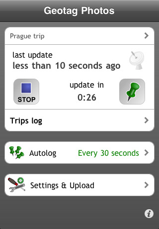
Geotag Photos Lite - This iPhone application works like GPS Data Logger - it logs your positions during your trip. There are various logging modes, that will fit your needs - continuous mode logs your every change and is best if you need most accurate data, from the other hand time based logging (logs position every few minutes) saves your iPhone battery. Our iPhone app can run perfectly in sleep mode.
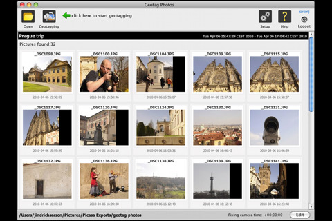
When you return from your trip, you can synchronize logged data with our desktop application and geotag photos taken by your camera. We support both amateur cameras (compact) and professional ones (DSLR). We also supports geotagging of various RAW formats (.NEF, CRW, CR2 and others). You can also export your logged data to well know and widely used GPX format - in this new version is NOT NECESSARY to upload data to remote server, you have your GPX files always prepared and can get them using iTunes file sharing function or you can send them from iPhone by email.
few ideas how to use Geotagged photos:
- use Places function of modern viewing applications (iPhoto, Aperture, Picasa) to see your photos on map
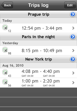
- find your photos by place (for example find quickly all photos from New Your in your Photo library)
- upload Geotagged photos to social sites (flickr or so)
· complete solution - iPhone application for automatic storing of location data & desktop application for geotagging of pictures. No need to purchase another desktop app!
· supports iOS 4 multitasking (but runs on older firmware without multitasking as well)
· iPhone application - tracking of your position, multiple logging modes, working in sleep mode, displays logged track on the map
· Export to GPX standard format - 3 ways how to do this: through iTunes, by email or from web. No need to have internet or wifi connection for GPX export!
· Geotagging desktop application - Geotag your JPG or RAW files - quick and easily!
· works perfectly on any operating system - Mac OS X, Windows and even Linux
· required iPhone device with GPS (iPhone 3G and later or iPad 3G, not for iPad Wifi or iPod)
· supported image formats: jpg, nef, cr2, crw, dcr, ciff, erf, orf, k25, kdc, mef, mrw, nrw, pef, raf, tif, tiff, raw, arw, rw2, srf, sr2, srw, x3f, dng
This Lite version supports all functions of full version, except automatic logging. You can enable automatic logging for 3 days to try it.
What's New in This Release:
· bugfix release
What's New in 2.83:
· fix of Australian timezone issue & iOS5 improvements
What's New in 2.82:
· changes for iOS 5
· notifications, when GPS signal was lost or when timezone changed
What's New in 2.72:
· bugfix - no more crash on Accuracy settings screen
What's New in 2.6:
· improved timezone support
· reupload function
· badge icon with number of positions logged on background
|


")


 for iPhone/iPad")

