Platforms: iPhone, iPad, iPod Touch, Apple iPhone OS
Categories: Travel & Navigation
Upload date: 1 May 13
Developer: HipGeo
License: Freeware
Downloads: 76
HipGeo is the most convenient way to track where you go, take photos, record the world around you, and tell the story about where you've been or traveled. This is a great family communication and photo sharing tool. HipGeo provides an easy, safe way for families and groups of friends to automatically share a moment, event, or trip while maintaining their desired level of privacy.
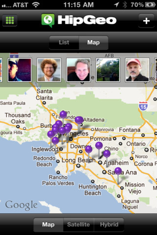
HipGeo lets you know where your friends and family members are with automatic updates or a simple push of a button. And, it lets you share your location, a place, a route or photos through full integration with Facebook, Twitter, texting, and email.
Keep a record of your life using our battery efficient GPS tracking features and stay connected with different groups of people while protecting your privacy. This is like "an app that follows you".
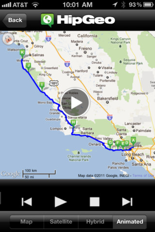
· Simply take photos with HipGeo and create a shareable trip to tell your story with an animated map and slide shows.
· We designed "Places mode" to track the places you visit, but not your exact routes. As a result, for a background running GPS app, you should find that HipGeo stretches your battery life much longer than other solutions. Many users can leave it on all day.
· For increased accuracy, track where you've been and how you got there with the "Places and Routes" mode.
· Automatically increases tracking accuracy when connected to power devices like a car charger.
· Automatically share your location without effort, or choose to keep it private with intuitive privacy controls.
· "Where are you? I'm here" One touch to share your location and request your friends' location, even with tracking turned off.
· Manually share places and routes with friends via SMS, email, Facebook and Twitter. Post a place, a travel, or your whole day to your wall, or tweet it, or text it, or email it.
· Create distribution lists for different groups.
· Maps integration allowing easy directions to or from your location.
· Easily invite friends from your address book, Facebook and Twitter.
· Control privacy levels with "just me," "just friends," or "everyone" levels.
· Make and share comments and photos.
· Access by phone or Web at hipgeo.com.
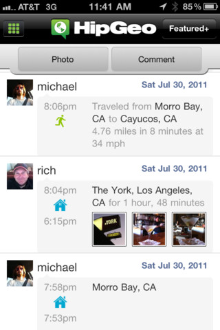
· Create an automatic journal record of your day, keeping a history of where you've been and what you've been up to, accessible through one touch "My Day", and via daily emails containing the previous day's travels and places.
· Get insight into your routines, interests, activities, and connections.
· Measure and compare your different commute routes.
What's New in This Release:
· Numerous bug fixes
What's New in 2.1.2:
· Fixed camera crash and black screen.
· Speed improvements and refinements.
What's New in 2.1.1:
· Bulk photo uploads
· Bug fixes and other tweaks
Like it? Share with your friends!
If you got an error while installing Themes, Software or Games, please, read FAQ.
Supported operating systems:
Apple iOS 10.x (iPad), Apple iOS 10.x (iPhone), Apple iOS 11.x (iPad), Apple iOS 12.x (iPad), Apple iOS 12.x (iPhone), Apple iOS 4.0.x (iPhone), Apple iOS 4.0.x (iPod Touch), Apple iOS 4.2.x (iPad), Apple iOS 4.2.x (iPhone), Apple iOS 4.2.x (iPod Touch), Apple iOS 4.3.x (iPad), Apple iOS 4.3.x (iPhone), Apple iOS 4.3.x (iPod Touch), Apple iOS 5.0 (iPad), Apple iOS 5.0 (iPhone), Apple iOS 5.0 (iPod Touch), Apple iOS 6.0 (iPad), Apple iOS 6.0 (iPhone), Apple iOS 6.0 (iPod Touch), Apple iOS 7.0 (iPad), Apple iOS 7.0 (iPhone), Apple iOS 7.0 (iPod Touch), Apple iOS 8.x (iPad), Apple iOS 8.x (iPhone), Apple iOS 8.x (iPod Touch), Apple iOS 9.x (iPad), Apple iOS 9.x (iPhone), Apple iOS 9.x (iPod Touch)
Similar Software:
Packing Pro Packing Pro is a super-enhanced version of the popular, top-ranking Packing app
TripDeck TripDeck - The best itinerary organizer out there – and it’s FREE. Manage your hotel reservations, car rentals, flights, cruises, restaurants, meetings and more with easy-to-read Trip Decks for each itinerary. You can also view your entire itinerary on a gorgeous map
Cold War Walking Tour in Berlin Cold War Walking Tour in Berlin - No place on Earth stood at the heart of the 20th Century conflict between the ideological poles of Communism and Capitalism like Berlin. A divided city in a divided Germany in a divided Europe in a divided world
FlightTrack Pro FlightTrack Pro - the best flight tracking app out there. Get push alerts, real-time flight itinerary updates, automatic synching, and beautiful, zoomable maps that work offline. Flight cancelled? It will even help you find alternate flights.
FlightTrack Pro works seamlessly with TripIt. Forward your airline confirmation emails to plans@tripit
Tokyo City Maps Tokyo City Maps - software that helps you download and store the travel maps and plans you need. This super-handy app lets you download publicly available maps and store them on your iPhone or iPod Touch. You can download the maps when you have fast wifi connection - and then use any time in the future without delay
TransitM&S San Antonio VIA TransitM&S San Antonio VIA - TransitM&S is an easy-to-use transit application that provides bus info for San Antonio's VIA Metropolitan Transit.
The app is designed for offline use. It is ideal for iPod Touch users. Even for iPhone users, it is designed to save money because AT&T no longer offers the unlimited data plan
Phoenix Maps Phoenix Maps - software that helps you download and store the travel maps and plans you need. This super-handy application lets you download publicly available maps and store them on your iPhone or iPod Touch. You can download the maps when you have fast wifi connection - and then use any time in the future without delay
iBART Live iBART Live From the makers of the acclaimed iBART, iBART Live is an intelligent transit application for Bay Area Rapid Transit. It is essential to all BART riders — from the occasional to the daily, the tourist to the commuter
Dearborn(Michigan) World Travel Dearborn(Michigan) World Travel - Map with locate me function makes you free to move.
Background reading always accompanies you on your trip
London Central Bus 10 London Central Bus 10 - The new Zuti London Bus map has finally arrived, making it easy to travel by bus anywhere in central London. This clear and colourful map covers a detailed street level area of 6 miles by 4 miles and includes over 1300 bus stops and 189 bus routes
Other Software by developer «HipGeo»:
not found
Comments on HipGeo:
Comments not found
If you noted an error or download link is broken, please, report it via this page or use comments.
HipGeo is compatible with your device Apple iPhone 6 Plus


 World Travel")
