Platforms: iPhone, iPad, iPod Touch, Apple iPhone OS
Categories: Travel & Navigation
Upload date: 7 May 11
Developer: Flytomap
License: Commercial
Price: 12.99 $
Downloads: 45
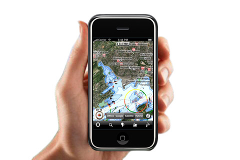
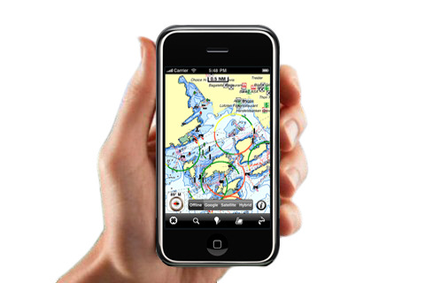
Marine: Solent - GPS Map Navigator - FlytoMap provides complete, quick and easy to use map applications for navigation for iPhone. Continues in the tradition of offering depth of information and functionality across expected places all over the world, exploring the map you get maximum details obtaining detailed information of every object on the map.
FlytoMap processes different types of maps for navigation for different categories:
WATER MAPS (Marine):
Water map navigator is the new ‘Marine Navigator for iPhone’ contains embedded Electronic Nautical Charts (ENC) from NOAA compressed to a large coverage. You can now download the application and transform your iPhone in a chart plotter with best NOAA, ENC S57 cartography; which includes Anchoring areas, Fishing areas, restriction areas, obstructions, rocks, Buoys, Beacons, Lights, Depth contours with Values display on map, Spot Soundings and more. The only marine app available in the market with such huge information. Every effort is made to be as accurate as possible when presenting information for every destination.
PARK MAPS:
Park map applications are extremely advanced contains embedded electronic charts with all information collected from the National Park Service and local sources. The maps contain all multiple trails (Hiking, biking, Stairway trails, Bicycle trails, Equestrian trails etc.,) and Point of interests (POI) like Campgrounds, Eating places, Ranger Stations, Picnic areas, Boat/Canoe launching, Parking areas etc., which are provided depending on the relevant park areas they exist.
LAKE MAPS:
We offer high quality lake maps with detailed information and important features compressed to assure the larger coverage in USA region. Lake maps contain most important DNR lakes with detailed ‘Depth Contours, Boat Ramps, Fishing spots etc. Also includes Trails, Roads and Railways information.
TRAVEL MAPS:
These Maps treat you mostly with information of both Marine and terrain correspondingly. These are the most preferable Maps to travel especially for fascinating recreational voyages, map focus the best Beach spots along the Coast line, Major ports, Sailing, Fishing, Picnic areas, Parks, Hiking, Biking, Clubs, restaurants, Famous Hotels, Museums, Shopping areas, and much more.
· Use Latitudes and Longitudes to go to your favorite places
· Insert the target/destination 'Waypoint' and see in real time your speed, distance and direction to destination
· Insert Unlimited Markers near favorite places on the map
· Search your Favorite points directly
· Zoom, Rotate and Pan fast just by a finger touch
· Navigate and see your GPS position on the map
· Geo-Tagged photo management
· Set On/Off Elevation Contours if you feel data is cluttering
What's New in This Release:
· Minor bug fixed
· Retina display management
Like it? Share with your friends!
If you got an error while installing Themes, Software or Games, please, read FAQ.
Supported operating systems:
Apple iOS 10.x (iPad), Apple iOS 10.x (iPhone), Apple iOS 11.x (iPad), Apple iOS 12.x (iPad), Apple iOS 12.x (iPhone), Apple iOS 4.0.x (iPhone), Apple iOS 4.0.x (iPod Touch), Apple iOS 4.2.x (iPad), Apple iOS 4.2.x (iPhone), Apple iOS 4.2.x (iPod Touch), Apple iOS 4.3.x (iPad), Apple iOS 4.3.x (iPhone), Apple iOS 4.3.x (iPod Touch), Apple iOS 5.0 (iPad), Apple iOS 5.0 (iPhone), Apple iOS 5.0 (iPod Touch), Apple iOS 6.0 (iPad), Apple iOS 6.0 (iPhone), Apple iOS 6.0 (iPod Touch), Apple iOS 7.0 (iPad), Apple iOS 7.0 (iPhone), Apple iOS 7.0 (iPod Touch), Apple iOS 8.x (iPad), Apple iOS 8.x (iPhone), Apple iOS 8.x (iPod Touch), Apple iOS 9.x (iPad), Apple iOS 9.x (iPhone), Apple iOS 9.x (iPod Touch), Apple iPhone OS 3.1.x, Apple iPhone OS 3.1.x (iPod Touch), Apple iPhone OS 3.2.x (iPad)
Similar Software:
Saint Lucia - GPS Map Navigator Saint Lucia - GPS Map Navigator - FlytoMap provides complete, quick and easy to use map applications for navigation for iPhone. Continues in the tradition of offering depth of information and functionality across expected places all over the world, exploring the map you get maximum details obtaining detailed information of every object on the map
Green Mountain National Forest - GPS Map Navigator Green Mountain National Forest - GPS Map Navigator - Continues in the tradition of offering depth of information and functionality across expected places all over the world, exploring the map you get maximum details obtaining detailed information of each object on the map
Nav4D Benelux Nav4D Benelux - Single intuitive menu gives the user all the information needed to begin a journey with confidence. Along the way take advantage of the automatic local and global search with rich contents.
Designed to attract everyone, the new interface concept makes usability and design a key point. Nav4D is the perfect navigation system for iPhone
Navfree GPS + Street View Italy Navfree GPS + Street View Italy - Navfree is a free GPS navigation solution for iOS devices. The app uses OpenStreetMap data, created and updated by thousands of users from all over the world.
The maps are stored locally on the device, so there is no need for a data connection
TomTom Iberia TomTom Iberia - Get the TomTom navigation app and have smart, easy-to-use, turn-by-turn navigation on your iPhone or iPod touch, whenever and wherever you need it.
And, now, never miss a turn. The new TomTom app guides you even while you are on a call or running a different app on your iPhone
Death Valley National Park - GPS Map Navigator Death Valley National Park - GPS Map Navigator continues in the tradition of offering depth of information and functionality across expected places all over the world, exploring the map you get maximum details obtaining detailed information of each object on the map
Jamaica - GPS Map Navigator Jamaica - GPS Map Navigator - FlytoMap provides complete, quick and easy to use map applications for navigation for iPhone. Continues in the tradition of offering depth of information and functionality across expected places all over the world, exploring the map you get maximum details obtaining detailed information of every object on the map
Puerto Vallarta GPS Guide The only thing we do, help you to move freely as an alien, by "Offline" & "GPS"
Nav4D Hawaii Nav4D Hawaii - Single intuitive menu gives the user all the information needed to begin a journey with confidence. Along the way take advantage of the automatic local and global search with rich contents.
Designed to attract everyone, the new interface concept makes usability and design a key point. Nav4D is the perfect navigation system for iPhone
WHERE (iPhone) WHERE - Are you ready to delete dozens of other applications from your iPhone? WHERE is the only application you'll need you need for location based information.
WHERE connects you to people, places and things around you
Theodore Roosevelt National Park - Standard Theodore Roosevelt National Park - Standard - Continues in the tradition of offering depth of information and functionality across expected places all over the world, exploring the map you get maximum details obtaining detailed information of each object on the map
Mauritius - GPS Map Navigator Mauritius - GPS Map Navigator - FlytoMap provides complete, quick and easy to use map applications for navigation for iPhone. Continues in the tradition of offering depth of information and functionality across expected places all over the world, exploring the map you get maximum details obtaining detailed information of every object on the map
Gaudalupe HD - GPS Map Navigator Gaudalupe HD - GPS Map Navigator - FlytoMap provides complete, quick and easy to use map applications for navigation. Continues in the tradition of offering depth of information and functionality across expected places all over the world, exploring the map you get maximum details obtaining detailed information of every object on the map
Sequoia - Kings National Park - GPS Map Navigator Sequoia - Kings National Park - GPS Map Navigator - Continues in the tradition of offering depth of information and functionality across expected places all over the world, exploring the map you get maximum details obtaining detailed information of each object on the map
Mount Ranier National Park - Standard Mount Ranier National Park - Standard - Continues in the tradition of offering depth of information and functionality across expected places all over the world, exploring the map you get maximum details obtaining detailed information of each object on the map
Lake Powell - Fishing Lake Powell - Fishing - Lake Powell is the ultimate recreational spot for millions of visitors having 186 miles length with 1960 miles of shoreline for excellent activities.
Lake Powell is well known for activities like Swimming, Boating and Kayaking, Fishing, Scuba diving, Snorkeling, Water skiing and sightseeing. Photographic opportunities around are plentiful
Marine: Oslo Fjord - GPS Map Navigator Marine: Oslo Fjord - GPS Map Navigator - FlytoMap provides complete, quick and easy to use map applications for navigation for iPhone. Continues in the tradition of offering depth of information and functionality across expected places all over the world, exploring the map you get maximum details obtaining detailed information of every object on the map
Ouachita National Forest Ouachita National Forest - Continues in the tradition of offering depth of information and functionality across expected places all over the world, exploring the map you get maximum details obtaining detailed information of each object on the map
Marine: Miami to Key West - GPS Map Navigator Marine: Miami to Key West - GPS Map Navigator - Continues in the tradition of offering depth of information and functionality across expected places all over the world, exploring the map you get maximum details obtaining detailed information of each object on the map


")


