Platforms: iPhone, iPad, iPod Touch, Apple iPhone OS
Categories: Travel & Navigation
Upload date: 17 Sep 14
Developer: Garmin
License: Freeware
Downloads: 329
BaseCamp Mobile - BaseCamp Mobile is a companion app for the Garmin fenix GPS watch. It allows you to wirelessly download data from your watch to the iPhone.
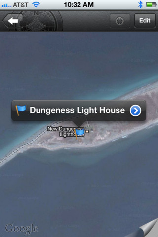
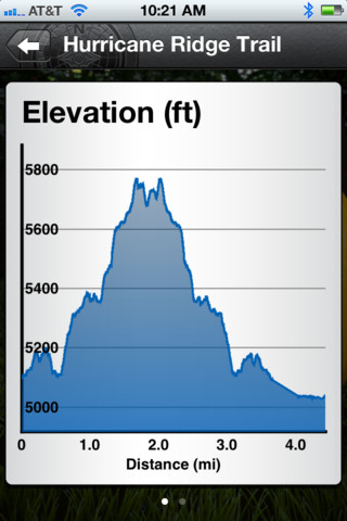
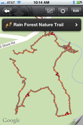
Downloaded data can be used to view routes and tracks on a map. Very useful for recording and reviewing your outdoor activities.
· Easy to use
· View routes and tracks on a map
· No need to buy additional maps
What's New in This Release:
· Added support for searching and viewing Garmin Adventures.
· Added support for sharing Adventures, GPX data (tracks, waypoints, etc.), and photos
· New look for iOS7.
What's New in 2.0:
· Cloud support
· Oregon 600 support
· Fixed reported app crashes
· Other miscellaneous fixes
Like it? Share with your friends!
If you got an error while installing Themes, Software or Games, please, read FAQ.
Supported operating systems:
Apple iOS 10.x (iPad), Apple iOS 10.x (iPhone), Apple iOS 11.x (iPad), Apple iOS 12.x (iPad), Apple iOS 12.x (iPhone), Apple iOS 6.0 (iPad), Apple iOS 6.0 (iPhone), Apple iOS 6.0 (iPod Touch), Apple iOS 7.0 (iPad), Apple iOS 7.0 (iPhone), Apple iOS 7.0 (iPod Touch), Apple iOS 8.x (iPad), Apple iOS 8.x (iPhone), Apple iOS 8.x (iPod Touch), Apple iOS 9.x (iPad), Apple iOS 9.x (iPhone), Apple iOS 9.x (iPod Touch)
Similar Software:
Victorville (CA, USA) Map Offline Victorville (CA, USA) Map Offline - This will be perfect when you are traveling and you don't have internet connection. This Offline Maps is not a replacement of Google Maps. It is used when you don't have internet connection and want to use maps
Cevennes National Park - GPS Map Navigator Cevennes National Park - GPS Map Navigator - FlytoMap provides complete, quick and easy to use map applications for navigation for iPhone. Continues in the tradition of offering depth of information and functionality across expected places all over the world, exploring the map you get maximum details obtaining detailed information of every object on the map
Sygic Poland: GPS Navigation Sygic Poland: GPS Navigation - Sygic is a premium turn-by-turn GPS navigation application
Whibbit Whibbit lets you tell your friends and family where you are with a few clicks. Updating your Facebook and Twitter status has never been easier.
What's New in This Release:
· This update introduces several tweaks to the interface
Marine: Scotland - GPS Map Navigator Marine: Scotland - GPS Map Navigator - FlytoMap provides complete, quick and easy to use map applications for navigation for iPhone. Continues in the tradition of offering depth of information and functionality across expected places all over the world, exploring the map you get maximum details obtaining detailed information of every object on the map
Marine: Chesapeake Bay - GPS Map Navigator Marine: Chesapeake Bay - GPS Map Navigator - Continues in the tradition of offering depth of information and functionality across expected places all over the world, exploring the map you get maximum details obtaining detailed information of each object on the map
Granada GPS Guide The only thing we do, help you to move freely as an alien, by "Offline" & "GPS"
New Caledonia - GPS Map Navigator New Caledonia - GPS Map Navigator - FlytoMap provides complete, quick and easy to use map applications for navigation. Continues in the tradition of offering depth of information and functionality across expected places all over the world, exploring the map you get maximum details obtaining detailed information of every object on the map
Canyonlands National Park - GPS Map Navigator Canyonlands National Park - GPS Map Navigator - FlytoMap provides complete, quick and easy to use map applications for navigation for iPhone. Continues in the tradition of offering depth of information and functionality across expected places all over the world, exploring the map you get maximum details obtaining detailed information of every object on the map
Turkey GPS Turkey GPS is a professional Car, Bike and Pedestrian navigation system for iPhone and iPad. This system not only for Car navigation, but also for pedestrian.
· 2D and 3D navigation mode and map.
· The speed is very fast.
· Using vector map which owns small size and can zoom in any level.
· Elegant operations
Other Software by developer «Garmin»:
Garmin StreetPilot onDemand Garmin StreetPilot onDemand brings the power of Garmin navigation to your iPhone with rich navigation features for walking or driving, a simple and intuitive user interface, and an amazingly low price. Using your data connection, StreetPilot onDemand always has access to the most up-to-date maps for the U.S
Garmin UK & Ireland Garmin UK & Ireland - Download Garmin StreetPilot Onboard UK & Ireland and give your iPhone the best in GPS navigation... with free camera alerts, photoReal junction views, 3D buildings, and more
Garmin N. America Garmin N. America - Download Garmin StreetPilot Onboard and give your iPhone the best in GPS navigation...even when you don’t have cell coverage. Maps reside on your device, so you can look up addresses and millions of points-of-interest such as gas stations, restaurants and ATMs without needing wireless coverage
Garmin Tracker (iPhone) Garmin Tracker (iPhone) - Brought to you by the worldwide leader in GPS, Garmin Tracker — combined with a GPS-enabled Garmin tracking device (purchase required) — lets you track what’s important while on the go.
Garmin Tracker is a free, unique application that'll help keep tabs on whatever's important to you
Garmin viago for Android Garmin viago for Android - Garmin viago turns your Android smartphone or tablet into a fully featured personal GPS navigator. The app can safely guide you to your destination with clear turn-by-turn directions, lane assistance to help you navigate complex junctions and speed limit indicators to help you avoid getting speeding tickets
Garmin Thailand Garmin Thailand - Garmin StreetPilot is a powerful GPS navigation solution for iOS devices. It comes preloaded with the latest map of Thailand.
Garmin Street offers many useful features, such as turn-by-turn directions, photo-realistic junction views, 3D buildings, exit services, speed cameras, and more
Garmin GTN Trainer Garmin GTN Trainer - The Garmin GTN 750 Trainer allows you to experience the pilot interface and provide an on-the-ground environment to learn the basic operation of the avionics
Garmin Indonesia Garmin Indonesia - Garmin StreetPilot is a powerful GPS navigation solution for iOS devices. It comes preloaded with the latest map of Indonesia.
Garmin Street offers many useful features, such as turn-by-turn directions, photo-realistic junction views, 3D buildings, exit services, speed cameras, and more
Garmin GTN Trainer Garmin GTN Trainer - The Garmin GTN 750 Trainer allows you to experience the pilot interface and provide an on-the-ground environment to learn the basic operation of the avionics
Garmin Tracker (Android) Garmin Tracker (Android) - Brought to you by the worldwide leader in GPS, Garmin Tracker — combined with a GPS-enabled Garmin tracking device (purchase required) — lets you track what’s important while on the go.
Garmin Tracker is a free, unique application that will help keep tabs on whatever is important to you


 Map Offline")


