Platforms: iPhone, iPad, iPod Touch, Apple iPhone OS
Categories: Travel & Navigation
Upload date: 12 Apr 13
Developer: TeleNav
License: Commercial
Price: 0.99 $
Downloads: 97
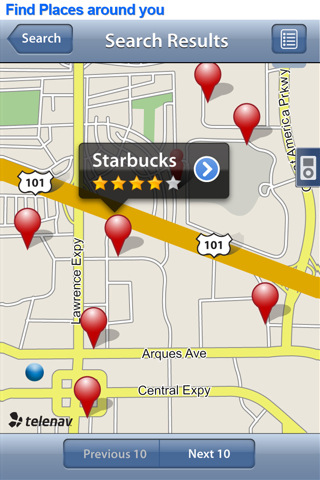
Navigation By TeleNav - TeleNav GPS Plus - TeleNav GPS Plus is your everyday navigator that helps you decide where to go, how to get there, and what to do when you are there.
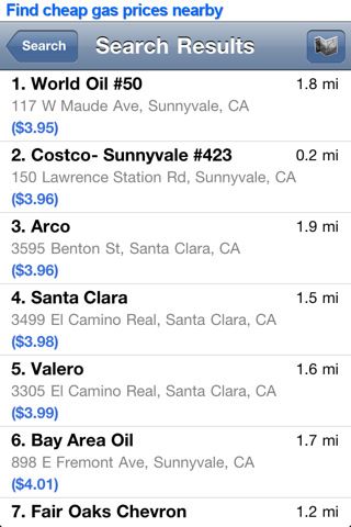
· Find cheap gas prices nearby - updated daily!
· Get clear spoken turn-by-turn directions from people, not robots
· Traffic-guided routing helps you avoid traffic jams
· Auto rerouting takes you to your destination if you ever miss a turn or take a detour
What's New in This Release:
· iOS6 support and bug fixes
What's New in 7.0.0.19:
· This update fixes a critical bug that blocked iPhone 4S users from starting the app.
What's New in 7.0.0.15i:
· Connect to Sony App Radio and get navigation in your car dashboard
· Check out the updated look and feel of the app
If you got an error while installing Themes, Software or Games, please, read FAQ.
Supported operating systems:
Apple iOS 10.x (iPad), Apple iOS 10.x (iPhone), Apple iOS 11.x (iPad), Apple iOS 12.x (iPad), Apple iOS 12.x (iPhone), Apple iOS 4.0.x (iPhone), Apple iOS 4.0.x (iPod Touch), Apple iOS 4.2.x (iPad), Apple iOS 4.2.x (iPhone), Apple iOS 4.2.x (iPod Touch), Apple iOS 4.3.x (iPad), Apple iOS 4.3.x (iPhone), Apple iOS 4.3.x (iPod Touch), Apple iOS 5.0 (iPad), Apple iOS 5.0 (iPhone), Apple iOS 5.0 (iPod Touch), Apple iOS 6.0 (iPad), Apple iOS 6.0 (iPhone), Apple iOS 6.0 (iPod Touch), Apple iOS 7.0 (iPad), Apple iOS 7.0 (iPhone), Apple iOS 7.0 (iPod Touch), Apple iOS 8.x (iPad), Apple iOS 8.x (iPhone), Apple iOS 8.x (iPod Touch), Apple iOS 9.x (iPad), Apple iOS 9.x (iPhone), Apple iOS 9.x (iPod Touch), Apple iPhone OS 3.1.x, Apple iPhone OS 3.1.x (iPod Touch), Apple iPhone OS 3.2.x (iPad)
Similar Software:
real Tide real Tide is able to calculate TIDE at YOUR GPS position! Flytomap's unique copyrighted algorithm is able to do it nicely!
Tidal flows are important for navigation, and significant errors in position occur if they are not accommodated.
The Tides, Currents, and Water Levels Map provides predicted times and heights of high and low waters
Barbados GPS Map Barbados GPS Map is a navigation App for the country of Barbados. All application features and map data is stored within your iPhone, allowing you to use the app freely without the worry of expensive data charges. Fast, simple user interface with detailed map data allows you to navigate throughout Barbados using your iPhone
Isola d'Elba - GPS Map Navigator Isola d'Elba - GPS Map Navigator - FlytoMap provides complete, quick and easy to use map applications for navigation for iPhone. Continues in the tradition of offering depth of information and functionality across expected places all over the world, exploring the map you get maximum details obtaining detailed information of every object on the map
Tilburg - Breda (Netherland) Map Offline Tilburg - Breda (Netherland) Map Offline - This will be perfect when you are traveling and you don't have internet connection. This Offline Maps is not a replacement of Google Maps. It is used when you don't have internet connection and want to use maps
Iran GPS Iran GPS is a professional Car, Bike and Pedestrian navigation system for iPhone and iPad. This system not only for Car navigation, but also for pedestrian.
· 2D and 3D navigation mode and map.
· The speed is very fast.
· Using vector map which owns small size and can zoom in any level.
· Elegant operations
Garajonay National Park - GPS Map Navigator Garajonay National Park - GPS Map Navigator - FlytoMap provides complete, quick and easy to use map applications for navigation for iPhone. Continues in the tradition of offering depth of information and functionality across expected places all over the world, exploring the map you get maximum details obtaining detailed information of every object on the map
Nav4D France Nav4D France - Single intuitive menu gives the user all the information needed to begin a journey with confidence. Along the way take advantage of the automatic local and global search with rich contents.
Designed to attract everyone, the new interface concept makes usability and design a key point. Nav4D is the perfect navigation system for iPhone
NAVIGON EU 10 NAVIGON EU 10 - With the NAVIGON MobileNavigator you can transform your iPhone into a fully functional mobile navigation system that is every bit as good as the multi-award-winning personal navigation devices from NAVIGON in terms of its user-friendliness and features
Navfree GPS Live South Africa Navfree GPS Live South Africa - Navfree is a free GPS navigation solution for iOS devices. The app uses OpenStreetMap data, created and updated by thousands of users from all over the world.
The maps are stored locally on the device, so there is no need for a data connection
Rochester (NY) Map Offline Rochester (NY) Map Offline - This will be perfect when you are traveling and you don't have internet connection. This Offline Maps is not a replacement of Google Maps. It is used when you don't have internet connection and want to use maps
Other Software by developer «TeleNav»:
GPS by TeleNav GPS by TeleNav - TeleNav GPS is your everyday GPS application that helps you decide where to go, how to get there, and what to do when you're there
Smart Planner Smart Planner is an intelligent location-based calendar and expense management app for salespeople and realtors.
Smart Planner automatically synchronizes with your phone's calendars and provides the following features to ensure that you are always on time for your meetings
Scout by Telenav for iPhone Scout by Telenav for iPhone - Scout is a powerful GPS navigation solution for iOS devices. The app can quickly guide you to your chosen destination with spoken turn-by-turn directions.
In addition, Scout allows you to easily find points of interest around you, access traffic information, view commute times, and more
Smart Planner Smart Planner - Smart Planner is an intelligent location-based calendar and expense management app for salespeople and realtors.
Smart Planner automatically synchronizes with your phone's calendars and provides the following features to ensure that you are always on time for your meetings


 Map Offline")


 Map Offline")


