Platforms: iPhone, iPad, iPod Touch, Apple iPhone OS
Categories: Travel & Navigation
Upload date: 31 Mar 12
Developer: Fugawi Software
License: Commercial
Price: 4.99 $
Downloads: 18
Fugawi iMap: USA & Canada Topo Maps - Fugawi iMap: USA and Canada brings topo maps to your iPhone. It is great for hikers, boaters, anglers, educators, or anyone going off-road and into the back country. Now includes one-tap "instant swap" between Topo Map view and Google Maps view within the application.
Features:
=> USA and Canada Topos Included...
The easiest to use topo map app includes all of USA and Canadian Provinces!
=>See Your Position...
See your position easily on the map. View your position in Lat/Long or UTM, see your speed and heading, automatically centre map on your position.
=> Seamless Maps...
Seamlessly loads raster topographic maps via the iPhone internet connection and caches them in memory for use when outdoors and not in 3G, EDGE or WiFi coverage.
=> Satellite Photo Maps...
Swap between topo map and Google Maps view with a single tap. Use anywhere in the world with satellite maps. Create, view and edit waypoints and photo waypoints on either the included topo map or Google Satellite maps. Choose between street map, satellite map or hybrid (street + satellite) view.
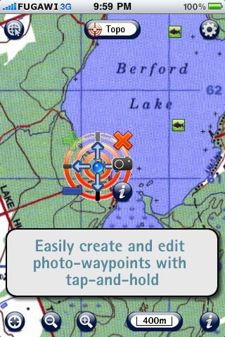
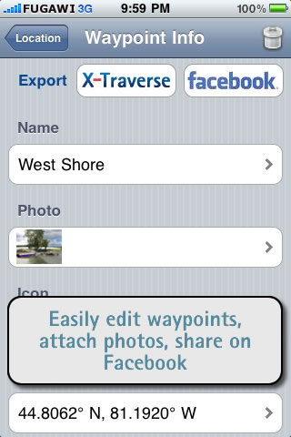
=> Easiest Waypoint Editor Ever...
Tap and hold on the screen to drop waypoints which may be custom edited by name, icon, co-ordinates, and text description. Easily move waypoints with a simple tap and drag.
==> GPS Photo Waypoints...
Tap to create a photo using the iPhone camera or select an image from the photo library.
==> X-Traverse Facebook App...
Send any waypoint or photo waypoint to your Facebook account. The waypoint and associated photo will appear in your Facebook account on an interactive map to share with your friends. Requires installation of the free X-Traverse Facebook App from x-traverse.com/facebook.
=> FREE Online Waypoint Storage and backup...
Waypoints can be transferred directly to your free account at X-Traverse.com which is included with your purchase of Fugawi iMap. To set up your account, launch iMap and select Settings|X-Traverse Account|Create X-Traverse Account. Save waypoints as GPX, KML or KMZ files. Upload waypoints in GPX format.
=> Location in Lat/Long or UTM...
See your current location, shown in latitude/longitude or UTM, with an easily visible position marker.
=> Map Pans as You Move...
Seamless map moves as you move.
=> Zoom In / Out...
Zoom in or out of the entire available map collection
=> Download All Scales...
Download all maps at all scales within 1, 5 or 10 km (or miles) of the screen center. Downloaded maps are saved to an auto-managed memory in the iPhone for fast retrieval on subsequent views of for use when outside of 3G, EDGE or Wi-Fi internet coverage.
=> Map Details...
See details such as scale, elevation contours, water bodies, major roads, railways, bridges, urban land use, and more.
Technical Details:
=> All of USA Topo Maps from U.S. Geological Survey included.
=> All of NRCan topo maps (CANMATRIX) for Canadian Provinces included.
=> Import and export waypoints as industry standard GPX files using the Fugawi X-Traverse web server (account included with App purchase). Use the GPX files on your computer with any software (such as Fugawi Global Navigator) which can import GPX data. Most iPhone Apps do not have this very helpful feature.
=> Topographic maps are delivered from Fugawi X-Traverse via the iPhone internet connection which then caches them in memory for use when outdoors and not in 3G, EDGE or WiFi coverage.
=> The iPhone location services are enabled for auto-selection of the map appropriate for your location, displaying your location in real-time with a easily visible marker. Spot elevation and direction of travel are also displayed when these location services are available to your iPhone model (e.g. iPhone 3G or 3GS).
=> The interface follows best practices for iPhone software: intuitive, simple to use, web connected.
What's New in This Release:
· Support for iOS 5.1
· Added range and bearing to/from GPS position to waypoint tool
What's New in 3.2.00:
Track Recording:
· Tracks may now be recorded.
· Control the line style of each track and hide/show tracks.
· Send tracks to your X-Traverse account or upload to Facebook with one tap.
Fast Photo Waypoints:
· New camera icon on the screen to instantly create a photo waypoint.
· Photo waypoints created this way are associated with the active track.
· Uploaded to Facebook with the associated track with one tap.
Supports Screen Rotation:
· Supports landscape/portrait rotation on iPhone and iPad.
Position Centering:
· In Settings, you can now choose to centre your location at middle of screen, or allow your position to move to edge of screen before re-centering.
Optimized for iOS 4:
· Supports multi-tasking of iOS 4.
Default Waypoints:
· Added user control for default waypoint and track symbols and line types.
Bug Fixes:
· Much improvement to stability of Google Maps interface.
Like it? Share with your friends!
If you got an error while installing Themes, Software or Games, please, read FAQ.
Supported operating systems:
Apple iOS 10.x (iPad), Apple iOS 10.x (iPhone), Apple iOS 11.x (iPad), Apple iOS 12.x (iPad), Apple iOS 12.x (iPhone), Apple iOS 4.0.x (iPhone), Apple iOS 4.0.x (iPod Touch), Apple iOS 4.2.x (iPad), Apple iOS 4.2.x (iPhone), Apple iOS 4.2.x (iPod Touch), Apple iOS 4.3.x (iPad), Apple iOS 4.3.x (iPhone), Apple iOS 4.3.x (iPod Touch), Apple iOS 5.0 (iPad), Apple iOS 5.0 (iPhone), Apple iOS 5.0 (iPod Touch), Apple iOS 6.0 (iPad), Apple iOS 6.0 (iPhone), Apple iOS 6.0 (iPod Touch), Apple iOS 7.0 (iPad), Apple iOS 7.0 (iPhone), Apple iOS 7.0 (iPod Touch), Apple iOS 8.x (iPad), Apple iOS 8.x (iPhone), Apple iOS 8.x (iPod Touch), Apple iOS 9.x (iPad), Apple iOS 9.x (iPhone), Apple iOS 9.x (iPod Touch), Apple iPhone OS 3.1.x, Apple iPhone OS 3.1.x (iPod Touch), Apple iPhone OS 3.2.x (iPad)
Similar Software:
Memphis Map Offline Memphis Map Offline - This will be perfect when you are traveling and you don't have internet connection. This Offline Maps is not a replacement of Google Maps. It is used when you don't have internet connection and want to use maps
Abbotsford Map Offline Abbotsford Map Offline - This will be perfect when you are traveling and you don't have internet connection. This Offline Maps is not a replacement of Google Maps. It is used when you don't have internet connection and want to use maps
Grand Canyon National Park - GPS Map Navigator Grand Canyon National Park - GPS Map Navigator - Continues in the tradition of offering depth of information and functionality across expected places all over the world, exploring the map you get maximum details obtaining detailed information of each object on the map
Rio De Janeiro Map Offline Rio De Janeiro Map Offline - This will be perfect when you are traveling and you don't have internet connection. This Offline Maps is not a replacement of Google Maps. It is used when you don't have internet connection and want to use maps
Madrid Walking Tours and Map Madrid Walking Tours and Map - No need to hop on a tour bus or join a group; now you can explore all the best attractions on your own, at your own pace, and at a cost that is only a fraction of what you would normally pay for a guided tour
Los Angeles Travel Guide - Lonely Planet Los Angeles Travel Guide - Lonely Planet - Welcome to sunny Los Angeles, a shiny city of reinvention where small talk always starts with a question: 'Where are you from?' This query reveals what's driving the city's energetic buzz - a perpetual in-flow of dreamers, go-getters and hustlers primed with unabashed optimism
Hamburg Street Map Hamburg Street Map - Lets you find all streets, and many useful locations such as ATM's, parkings, museums, and many others. Remembers where you've been so you can find that parking spot where you left your rental car
Carcassonne World Travel Carcassonne World Travel - map with locate me function makes you free to move.
Background reading always accompanies you on your trip
Luxembourg City Street Map Offline Luxembourg City Street Map Offline - You don't need to have internet connection for this to work as the map is stored on your iPhone or iPod Touch. Ideal for saving roaming charges or having to find the local wifi to access the built-in map application.
What's New in This Release:
· iOS 5 compatibility changes.
· Further bug fixes and improvements
New York Walking Tours and Map New York Walking Tours and Map - No need to hop on a tour bus or join a group; now you can explore all the best attractions on your own, at your own pace, and at a cost that is only a fraction of what you would normally pay for a guided tour
Other Software by developer «Fugawi Software»:
Fugawi iMap: Sweden SV-2 Svealand Fugawi iMap: Sweden SV-2 Svealand - "Fugawi iMap: Sweden SV-2 Svealand" is a topographic mapping Application of part of Sweden. It is great for going off-road and into the back country. Those who prefer the entire country of Sweden in a single App should purchase "Fugawi iMap: Sweden Entire Country".
Features:
=> 1/4 of Sweden Included..
Fugawi iMap: Sweden SV-1 Gotaland Fugawi iMap: Sweden SV-1 Gotaland - "Fugawi iMap: Sweden SV-1 Gotaland" is a topographic mapping Application of part of Sweden. It is great for going off-road and into the back country. Those who prefer the entire country of Sweden in a single App should purchase "Fugawi iMap: Sweden Entire Country".
Features:
=> 1/4 of Sweden Included..
Fugawi iMap: Sweden SV-4 Norra Norrland Fugawi iMap: Sweden SV-4 Norra Norrland - "Fugawi iMap: Sweden SV-4 Norra Norrland" is a topographic mapping App of part of Sweden. It is great for going off-road and into the back country. Those who prefer the entire country of Sweden in a single App should purchase "Fugawi iMap: Sweden Entire Country".
Features:
=> 1/4 of Sweden Included..
Fugawi iMap: Sweden Entire Country Fugawi iMap: Sweden Entire Country - Fugawi iMap: Sweden Entire Country is a Topo Map application of Sweden for iPhone. It is great for going off-road and into the back country. For those who prefer a lower Price, the App is also sold in 4 regions of Sweden.
Features:
=> All of Sweden Included..
Fugawi iMap: Sweden SV-3 Sodra Norrland Fugawi iMap: Sweden SV-3 Sodra Norrland - "Fugawi iMap: Sweden SV-3 Sodra Norrland" is a topographic mapping Application of part of Sweden. It is great for going off-road and into the back country. Those who prefer the entire country of Sweden in a single App should purchase "Fugawi iMap: Sweden Entire Country"
Fugawi iMap: Germany Topo Maps Fugawi iMap: Germany Topo Maps - Topo Map application of Germany for iPhone.
Features:
=> All of Germany included. Includes 1:25,000, 1:50,000 and 1:200,000 scale topo maps for all of Germany from the Federal Agency for Cartography and Geodesy (Bundesamt für Kartographie und Geodäsie)
=> Seamless Maps..