Platforms: iPhone, iPad, iPod Touch, Apple iPhone OS
Categories: Science & Education
Upload date: 26 Nov 10
Developer: VITO Technology
License: Shareware
Price: 2.99 $
Downloads: 300
Star Walk Indispensable for amateurs and professionals, as well as for kids who are eager to learn, Star Walk will guide you through the night sky in style.
Star Walk is your personal planetarium that can answer all of your curiosities about the sky! For anyone who is interested in stargazing, amateurs or professionals Star Walk makes discovering more than 9,000 stars, planets, constellations, and messier objects as beautiful and easy as it has never been before!
Use the Star Spotter function to see the sky in front of you in real-time. Tilt your iPhone towards the sky to activate the DIGITAL COMPASS which will determine location and orientation of your phone. The image on your screen will correspond to the area of the sky you are pointing your phone towards, and it will follow your movements. Please note that this function is available on 3GS devices only.
ATTENTION: for iPod Touch users please use manual selection of locations if Wifi is not available.
Star Walk features and how to use them:
DIGITAL COMPASS If you have an iPhone 3GS tilt your phone and the ''Star Spotter'' function will be activated, a live representation of what you see in the sky will appear on your display and the sky will start following your movements right, left, up, and down.
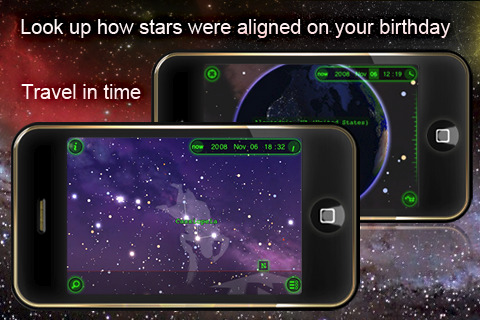
TIME MACHINE: tap the clock icon and scroll the time slider to watch the sky tonight or lets say two years from now. Travel in time and observe night sky on your birthday, be a part of astronomical events like eclipses and meteor showers.
SKY LIVE Window: open up the new window by tapping the moon-shaped button to see moon phases, elevation, and rising data for the Sun, Venus, Mercury, Jupiter, and Saturn.
PICTURE of the DAY: a push notification will appear on the Star Walk icon to tell you there is a new picture. Tap the right hand corner menu button, select glowing "Picture of the Day" button and a list of pictures will open in front of you. To learn more about the pictures tap the -i- icon on the top right hand corner.
BOOKMARKS: save a reminder of beautiful night sky observations, bookmark it on your iPhone and send it to your friends via e-mail.
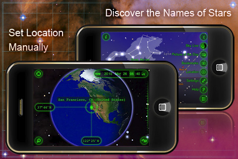
VIEW from the EARTH: Automatic and manual selection of locations on a 3D globe.
MOON PHASES: select the SKY LIVE window and see the moon phases for several days. Change dates on the top to see the moon phases for the past or for the future. Or zoom in the image of Moon and scroll the time slider.
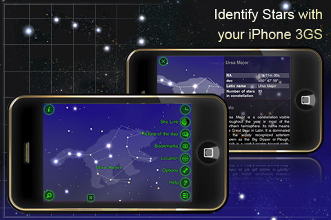
Wikipedia LINKS: select one celestial body and tap the - i - icon to activate the magnifier and read main information about it. To know more tap the Wiki icon at the bottom of the table and the Wikipedia page will open up.
SETTINGS: with the settings you can modify user preferences like you can change the screen to night mode, select brightness of the stars (change stars magnitude with a slider), put sounds on or off, switch on or off the constellations images.
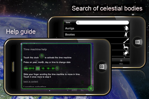
HELP GUIDE: the help tab includes some basic instruction on how to use time machine and location selection. FAQ section includes some common questions from our users and answers to them. For any doubts, suggestions or concerns contact us via support e-mail, Twitter or Facebook fan page.
What's New in This Release:
· Arabic translation
· BIG SCREEN - connect a second display to your iPhone or iPod and view the sky on it!
· Many bugs fixed
Like it? Share with your friends!
If you got an error while installing Themes, Software or Games, please, read FAQ.
Supported operating systems:
Apple iOS 10.x (iPad), Apple iOS 10.x (iPhone), Apple iOS 11.x (iPad), Apple iOS 12.x (iPad), Apple iOS 12.x (iPhone), Apple iOS 4.0.x (iPhone), Apple iOS 4.0.x (iPod Touch), Apple iOS 4.2.x (iPad), Apple iOS 4.2.x (iPhone), Apple iOS 4.2.x (iPod Touch), Apple iOS 4.3.x (iPad), Apple iOS 4.3.x (iPhone), Apple iOS 4.3.x (iPod Touch), Apple iOS 5.0 (iPad), Apple iOS 5.0 (iPhone), Apple iOS 5.0 (iPod Touch), Apple iOS 6.0 (iPad), Apple iOS 6.0 (iPhone), Apple iOS 6.0 (iPod Touch), Apple iOS 7.0 (iPad), Apple iOS 7.0 (iPhone), Apple iOS 7.0 (iPod Touch), Apple iOS 8.x (iPad), Apple iOS 8.x (iPhone), Apple iOS 8.x (iPod Touch), Apple iOS 9.x (iPad), Apple iOS 9.x (iPhone), Apple iOS 9.x (iPod Touch), Apple iPhone OS 3.1.x, Apple iPhone OS 3.1.x (iPod Touch), Apple iPhone OS 3.2.x (iPad)
Similar Software:
iCSC Clear Sky Chart iCSC Clear Sky Chart - iCSC downloads the Clear Sky Chart for your observing location. It's the astronomers forecast. It tells you when, in the next 48 hours, you might expect clear and dark skies.
What's New in This Release:
· Current site ID and name displayed in EnterSiteID page.
· Bug fixed in Connecticut sites list
Stargazers Stargazers is a fully-featured flash card application that helps you learn about astronomy
Solar Walk Solar Walk - Let's find out more about our neighboring planets in the Universe, play around with them determining the speed of circulation, time, choosing a particular planet to become the center of the Universe, seeing the moons of Saturn, Jupiter, Mars and Urano. The 3D model in the Solar Walk app is the exact reproduction of the real solar system
Stargazer (Free!) Stargazer (Free!) is a fully-featured flash card application that helps you learn about astronomy
Astronomy - Oxford Dictionary Astronomy - Oxford Dictionary - Edited by renowned author and broadcaster Ian Ridpath, with the help of over 20 expert contributors, the second edition of this highly popular dictionary contains over 4,200 up-to-date entries on all aspects of astronomy
Mars Envi Mars Envi - It's the best way to review decades worth of Mars missions, and to check out the latest happenings there
Planets for iPhone/iPad Planets is absolutely free in support of the International Year of Astronomy 2009. Over 1.2 million downloads so far!
Is that dot, a star or a planet? Answer questions like this with "Planets". Discover when you can see a certain planet, and where to look for it in relation to the stars
Space Envi Space Envi - Space Envi is a great way to begin exploring Web-based space imagery.
From Astronomy Pictures of the Day, to the early space missions, to the latest pictures from Mars, Space Envi displays Web-based space photos the way you would expect on the iPhone: full screen, with multi-touch controls, in automated slide shows
iAstronomica iAstronomica - An astronomy program that generates sky charts at any time, from anywhere on Earth
Other Software by developer «VITO Technology»:
Task2Gather Task2Gather is a unique Windows Mobile application for managing tasks and to-do’''s online. Besides it is a great collaborative tool that you can use on the go for accomplishing your tasks together with your family, friends or coworkers
Map of North Dakota (US State) Map of North Dakota (US State) - A map of the North Dakota by VITO Technology. Good for intercity travels with SmartMap.
SmartMap is a mobile device application which uses vector and raster maps. It is compatible with any NMEA protocol GPS receiver (Compact Flash socket, serial port, BlueTooth or sleeve)
Map of Pennsylvania (US State) Map of Pennsylvania (US State) - A map of the Pennsylvania by VITO Technology. Good for intercity travels with SmartMap.
SmartMap is a mobile device application which uses vector and raster maps. It is compatible with any NMEA protocol GPS receiver (Compact Flash socket, serial port, BlueTooth or sleeve)
GyroCompass 3D GyroCompass 3D - Augmented reality comes to the new iPod Touches! Tap the Gyrocompass 3D application on your iPhone 4 or 4th generation iPod Touch to turn it into a fully functioning three-dimensional compass
Map of Poland Map of Poland - A map of Poland. Good for intercity travels with SmartMap.
Layers include:
Towns
Settlements
Airports
Roads
Railroads
Rivers
Inland water
Administrative borders
International borders
Trees
Map scale is 1:1 million.
Good for use with any version of SmartMap. SmartMap can be purchased here
Map of Slovenia Map of Slovenia - A map of Slovenia. Good for intercity travels with SmartMap.
Layers include:
Towns
Settlements
Airports
Roads
Railroads
Rivers
Inland water
Administrative borders
International borders
Trees
Map scale is 1:1 million.
Good for use with any version of SmartMap. SmartMap can be purchased here
Map of Panama Map of Panama - A map of Panama. Good for intercity travels with SmartMap.
Layers include:
Towns
Settlements
Airports
Roads
Railroads
Rivers
Inland water
Administrative borders
International borders
Trees
Map scale is 1:1 million.
Good for use with any version of SmartMap. SmartMap can be purchased here
Map of Virginia (US State) Map of Virginia (US State) - A map of the Virginia by VITO Technology. Good for intercity travels with SmartMap.
SmartMap is a mobile device application which uses vector and raster maps. It is compatible with any NMEA protocol GPS receiver (Compact Flash socket, serial port, BlueTooth or sleeve)
Winterface Winterface is a mobile shell of next generation that can virtually replace the default Windows Mobile user interface. Winterface also gives users the full freedom of organizing interface exactly as they like it, with style and enhanced functionality
Map of Yemen Map of Yemen - A map of Yemen. Good for intercity travels with SmartMap.
Layers include:
Towns
Settlements
Airports
Roads
Railroads
Rivers
Inland water
Administrative borders
International borders
Trees
Map scale is 1:1 million.
Good for use with any version of SmartMap. SmartMap can be purchased here


")


")
")


")

