Platforms: iPhone, iPad, iPod Touch, Apple iPhone OS
Categories: Science & Education
Upload date: 22 Oct 12
Developer: VITO Technology
License: Freeware
Downloads: 163
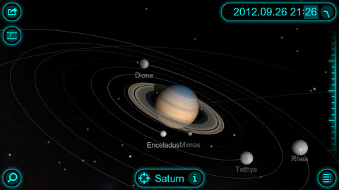
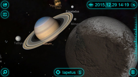
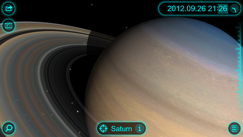
Solar Walk - Saturn - This app is a lite version of the popular astronomy software Solar Walk. It lets you explore Saturn, the sixth planet from the Sun, as well as its moons: Mimas, Enceladus, Tethys, Dione, Rhea, Titan, Hyperion, and Iapetus, in 3D.
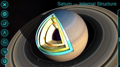
The application is packed with useful information, including size, mass, distance to the Sun, orbital velocity, internal structure, history of missions, and more. In addition, you can view beautiful images of each celestial body, as well as read the most interesting facts.
· GALAXY view - absolutely magical zoom out to view the whole galaxy option.
· TIME MACHINE - set any date you want including even minutes and take a travel through space and time.
· INFO - general info, its name, its mass, radius, distance to the sun, internal structure with the picture and science missions.
· MOONS - observe how many moons Saturn has and their track around the planet. Select one of the moons and learn.
· MIRRORING - wirelessly mirror the screen to an Apple TV 2.
· 3D MODE - to enjoy the view on 3D TV
Like it? Share with your friends!
If you got an error while installing Themes, Software or Games, please, read FAQ.
Supported operating systems:
Apple iOS 10.x (iPad), Apple iOS 10.x (iPhone), Apple iOS 11.x (iPad), Apple iOS 12.x (iPad), Apple iOS 12.x (iPhone), Apple iOS 4.3.x (iPad), Apple iOS 4.3.x (iPhone), Apple iOS 4.3.x (iPod Touch), Apple iOS 5.0 (iPad), Apple iOS 5.0 (iPhone), Apple iOS 5.0 (iPod Touch), Apple iOS 6.0 (iPad), Apple iOS 6.0 (iPhone), Apple iOS 6.0 (iPod Touch), Apple iOS 7.0 (iPad), Apple iOS 7.0 (iPhone), Apple iOS 7.0 (iPod Touch), Apple iOS 8.x (iPad), Apple iOS 8.x (iPhone), Apple iOS 8.x (iPod Touch), Apple iOS 9.x (iPad), Apple iOS 9.x (iPhone), Apple iOS 9.x (iPod Touch)
Similar Software:
Stargazer (Free!) Stargazer (Free!) is a fully-featured flash card application that helps you learn about astronomy
Earth Envi Earth Envi - OK, maybe not quite, but Earth Envi gives you access to some of the most amazing Web-based space photos of our home planet that you'll ever see
iAstronomica iAstronomica - An astronomy program that generates sky charts at any time, from anywhere on Earth
Planet Envi Planet Envi brings thousands of Web-based images of the sun, earth, moon and planets to your iPhone. It's part space museum, part planetarium show, part travel guide for our little corner of the universe
Solar Walk Free Solar Walk Free - This app is a lite version of the popular astronomy software Solar Walk. It lets you explore Saturn, the sixth planet from the Sun, as well as its moons: Mimas, Enceladus, Tethys, Dione, Rhea, Titan, Hyperion, and Iapetus, in 3D
Astrology Trivia Quiz Astrology Trivia Quiz features 9 different game modes, in both single and multiplayer for you to play and enjoy
HubbleSite HubbleSite, the online home of NASA’s Hubble Space Telescope, invites you to help choose the world’s most popular Hubble images. Get wallpapers, Hubble facts, and more.
Hubble’s vast collection of images awaits your critical and discerning eye
Astronaut Envi Astronaut Envi - Astronaut Envi brings thousands of Web-based space photos to your iPhone or iPod touch. If you've always wanted to be a space traveler, or just like looking at the amazing images our astronauts have returned, Astronaut Envi is for you
Star Walk for iPhone Star Walk Indispensable for amateurs and professionals, as well as for kids who are eager to learn, Star Walk will guide you through the night sky in style
iCSC Clear Sky Chart iCSC Clear Sky Chart - iCSC downloads the Clear Sky Chart for your observing location. It's the astronomers forecast. It tells you when, in the next 48 hours, you might expect clear and dark skies.
What's New in This Release:
· Current site ID and name displayed in EnterSiteID page.
· Bug fixed in Connecticut sites list
Other Software by developer «VITO Technology»:
Map of Syria Map of Syria - A map of Syria, divided into 12 smaller territories for the ease of use. Good for intercity travels with SmartMap. Layers include:
Towns
Settlements
Airports
Roads
Railroads
Rivers
Inland water
Administrative borders
International borders
Trees
Map scale is 1:1 million
Map of Spain Map of Spain - A map of Spain, divided into 8 smaller territories for the ease of use. Good for intercity travels with SmartMap.
Layers include:
Towns
Settlements
Airports
Roads
Railroads
Rivers
Inland water
Administrative borders
International borders
Trees
Map scale is 1:1 million
Map of Serbia Map of Serbia - A map of Serbia good for intercity travels with SmartMap.
Layers include:
Towns
Settlements
Airports
Roads
Railroads
Rivers
Inland water
Administrative borders
International borders
Trees
Map scale is 1:1 million.
Good for use with any version of SmartMap. SmartMap can be purchased here
Map of Pakistan Map of Pakistan - A map of Pakistan. Good for intercity travels with SmartMap.
Layers include:
Towns
Settlements
Airports
Roads
Railroads
Rivers
Inland water
Administrative borders
International borders
Trees
Map scale is 1:1 million.
Good for use with any version of SmartMap. SmartMap can be purchased here
Map of Texas (US State) Map of Texas (US State) - A map of the Texas by VITO Technology. Good for intercity travels with SmartMap.
SmartMap is a mobile device application which uses vector and raster maps. It is compatible with any NMEA protocol GPS receiver (Compact Flash socket, serial port, BlueTooth or sleeve)
VITO SmartNavigator VITO SmartNavigator comprises benefits of two navigation products: VITO SmartMap and VITO Navigator II
ScreenLock plug-in UIQ QC ScreenLock is a plug-in for VITO QuickContact for P800/P900. It provides essential functionality even when you don use your phone.
Keeps your screen locked preventing accidental taps on the screen.
Turns off the backlight and saves your battery life.
Displays big digital clock.
Can be unlocked by pressing the Jog Dial wheel
GyroCompass 3D GyroCompass 3D - Augmented reality comes to the new iPod Touches! Tap the Gyrocompass 3D application on your iPhone 4 or 4th generation iPod Touch to turn it into a fully functioning three-dimensional compass
Map of Vermont (US State) Map of Vermont (US State) - A map of the Vermont by VITO Technology. Good for intercity travels with SmartMap.
SmartMap is a mobile device application which uses vector and raster maps. It is compatible with any NMEA protocol GPS receiver (Compact Flash socket, serial port, BlueTooth or sleeve)
Map of Washington (US State) Map of Washington (US State) - A map of the Washington by VITO Technology. Good for intercity travels with SmartMap.
SmartMap is a mobile device application which uses vector and raster maps. It is compatible with any NMEA protocol GPS receiver (Compact Flash socket, serial port, BlueTooth or sleeve)

")


")


")


")
")