Backpacker GPS Trails Lite - Record hiking trails, backpacking trips, and camping adventures with Backpacker GPS Trails Lite. View maps, navigate with GPS and digital compass, take photos, and backtrack to the trailhead. GPS Trails Lite works in remote places like national parks, wilderness areas, and backcountry spots without relying on data and cell signals.
Supported Phones: GPS Trails Lite is designed and optimized for the iPhone 4, 3GS, and 3G. The 1st generation models lack a GPS chip required to run the application.
· Turn your phone into a GPS: Navigate via precise satellite signals in and out of cell network. Know your exact location at all times.
· Capture waypoints: Mark campsites, trailheads, water sources, summits, and more.
· Track every step: Record or follow your tracks and routes.
· Take photos: Shoot photos with your iPhone and see each photo’s exact lat/long location on a map.
· Get published: Every month the editors at Backpacker handpick adventures shared by its online community to be published in the magazine. Kickstart your adventure writing and photography career with GPS Trails.
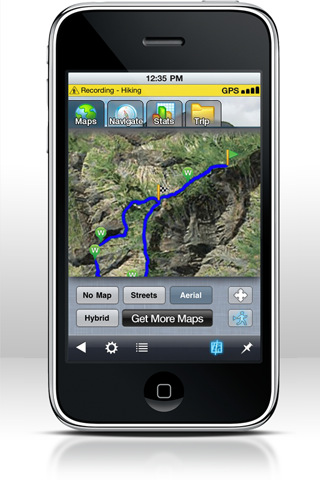
· View maps: See unlimited street, aerial, hybrid street/aerial maps.
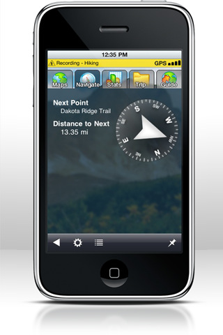
· Navigate on the trail: Use the digital compass to follow bearings or go to waypoints on the trail.
· View stats: Calculate calories, speed, distance, and elevation.
· Share adventures: Post trips on Facebook, Twitter, and BACKPACKER.com.
· Capture video: Shoot video and geotag it to an exact location on a map and auto-upload video to your YouTube account in GPS Trails Pro (3GS and 4 models only)
· Navigate super-detailed maps: View and download unlimited topo and terrain maps (Pro Only).
· Save maps: Store up 500MB of detailed maps on your iPhone for offline viewing in the backcountry. (Pro Only)
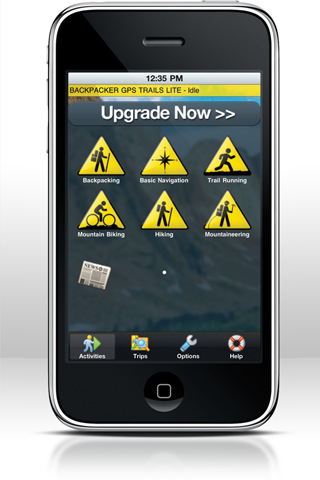
· Locate trips: Search by name or park, or select from trails near your current location--more than 3,500 Backpacker magazine editor-endorsed adventures in the United States.
· Download guides: Follow our step-by-step trail guides of popular trails and lesser-known routes in national parks, national forests, and local parks. From Acadia to Zion, you’ll find a trip for your next adventure. (Pro Only)
· Sync with paper maps: Use GPS Trails for advanced navigation with traditional paper maps. GPS Trails Pro can translate your GPS coordinates into several formats and map datum.
What's New in This Release:
· iPhone 5 - Full screen support added
· Forest Roads overlay added (for Elite users)
· Added map preview for Digital Map Bundles in the Store
· iOS6 Network issue fixed
· Other Miscellaneous bugs fixed
What's New in 5.3.1:
· Minor Enhancements to Messaging
· Minor Bug Fixes
· Additional Map Layers
· Change in Behavior of Caching with some Bing Map Layers.
What's New in 5.1:
· Fixed Viewing of Trip Bundles
· Added pages to Pro Trip lists
· Repaired of some Trip Sync bugs
· Added Stats to Trip Summary screen
· Miscellaneous bug fixes & improvements
What's New in 5.0.1:
· Premium Trip Content Purchase Repaired.
What's New in 1.5.3:
· Check out the our new national park trip bundles. Download the best dayhikes in Yosemite, Yellowstone, and Grand Canyon. See photos, download waypoints and routes, and get turn-by-turn hiking directions. All FREE.
What's New in 1.5.1:
· Minor bug fixes
Like it? Share with your friends!
If you got an error while installing Themes, Software or Games, please, read FAQ.
Supported operating systems:
Apple iOS 10.x (iPhone), Apple iOS 12.x (iPhone), Apple iOS 4.0.x (iPhone), Apple iOS 4.2.x (iPhone), Apple iOS 4.3.x (iPhone), Apple iOS 5.0 (iPhone), Apple iOS 6.0 (iPhone), Apple iOS 7.0 (iPhone), Apple iOS 8.x (iPhone), Apple iOS 9.x (iPhone), Apple iPhone OS 3.1.x
Similar Software:
Saskatoon (Canada) Map Offline Saskatoon (Canada) Map Offline - This will be perfect when you are traveling and you don't have internet connection. This Offline Maps is not a replacement of Google Maps. It is used when you don't have internet connection and want to use maps
Nav4D Philippines Nav4D Philippines - Single intuitive menu gives the user all the information needed to begin a journey with confidence. Along the way take advantage of the automatic local and global search with rich contents.
Designed to attract everyone, the new interface concept makes usability and design a key point. Nav4D is the perfect navigation system for iPhone
Nav4D Macedonia Nav4D Macedonia - Single intuitive menu gives the user all the information needed to begin a journey with confidence. Along the way take advantage of the automatic local and global search with rich contents.
Designed to attract everyone, the new interface concept makes usability and design a key point. Nav4D is the perfect navigation system for iPhone
Badlands National Park - GPS Map Navigator Badlands National Park - GPS Map Navigator - Continues in the tradition of offering depth of information and functionality across expected places all over the world, exploring the map you get maximum details obtaining detailed information of each object on the map
MotionX GPS Lite MotionX GPS Lite is for your outdoor life:
That's Walking, Hiking, Running, Cycling, Biking, Sailing, Skiing, Flying, Racing, Geocaching.
MotionX-GPS shows your position and track at all times on street, topo/terrain and satellite maps
Luxembourg City Map Offline Luxembourg City Map Offline - This will be perfect when you are traveling and you don't have internet connection. This Offline Maps is not a replacement of Google Maps. It is used when you don't have internet connection and want to use maps
Russia - iGO primo app Russia - iGO primo app - iGO primo app turns your iOS device into a powerful navigation system. Using the same experienced iGO Engine employed by GPS navigation devices all over the world, the app can reliably guide you to your destination in no time.
The software uses accurate offline maps which can be used anywhere
Kingston Map Offline Kingston Map Offline - This will be perfect when you are traveling and you don't have internet connection. This Offline Maps is not a replacement of Google Maps. It is used when you don't have internet connection and want to use maps
Allentown (PA,USA) Map Offline Allentown (PA,USA) Map Offline - This will be perfect when you are traveling and you don't have internet connection. This Offline Maps is not a replacement of Google Maps. It is used when you don't have internet connection and want to use maps
Archipielago de Cabrera National Park - GPS Map Navigator Archipielago de Cabrera National Park - GPS Map Navigator - FlytoMap provides complete, quick and easy to use map applications for navigation for iPhone. Continues in the tradition of offering depth of information and functionality across expected places all over the world, exploring the map you get maximum details obtaining detailed information of every object on the map
Other Software by developer «Trimble Navigation Limited»:
Backpacker GPS Trails Backpacker brings the outdoors straight to the reader's doorstep, inspiring and enabling them to go more places and enjoy nature more often. The authority on active adventure, Backpacker is the world's first GPS-enabled magazine and website, and the only outdoor media whose editors and network of map contributors personally map the hiking trails they publish
Geocache Navigator (Nokia) Provides hours of entertainment by combining the technology in your phone with one of the fastest-growing international hide and seek games - geocaching (also known as "GPS treasure hunt"). By using your phone's GPS and built-in Internet, Geocache Navigator creates a seamless and exciting experience
AllSport GPS (iPhone) AllSport GPS - Easier to use and delivering more value and power than ever, AllSport GPS transforms your iPhone into a full-featured workout tracker and GPS-enabled trainer for road cycling, mountain biking, running, walking, and other sports and fitness activities.
Tracking workouts on your iPhone is as easy as Start, Sweat, Stop
Cabela's Recon Hunt Cabela's Recon Hunt is the first mobile navigation application built solely for hunters. With Recon Hunt, you can find hunting spots on detailed maps, track wildlife, take trophy photos and backtrack home. Recon Hunt also tracks other essentials as well: weather forecasts, sun and moon phases, trip stats and ballistics information
AllSport GPS FREE Track workouts--runs, rides, walks & more. Map routes. Burn calories. Reach your fitness goals faster with AllSport GPS FREE. Track workouts--runs, walks, bike rides and other sports--on a map. View 25 heart-pounding stats as you sweat: time, speed, calories, distance
Trimble GPS Hunt Pro Trimble GPS Hunt Pro - Cabela's Recon Hunt is the first mobile navigation application built solely for hunters. With Recon Hunt, you can find hunting spots on detailed maps, track wildlife, take trophy photos and backtrack home. Recon Hunt also tracks other essentials as well: weather forecasts, sun and moon phases, trip stats and ballistics information
AllSport GPS LE (iPhone) AllSport GPS LE - Easy to use yet delivering power and outstanding value, AllSport GPS LE - a free version of the popular AllSport GPS fitness application - transforms your iPhone into a full-featured workout tracker and GPS-enabled trainer for road cycling, mountain biking, running, walking, and other sports and fitness activities


 Map Offline")


 Map Offline")


")
")


")