TouringNavigation - It is a navigation application program for the motorcycle and the bicycle, etc.
It is a navigation application for the motorcycle and the bicycle, etc.
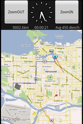
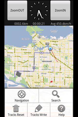
This application displays the route guide, tracks, the mileage that has been passed, the running time , and the mean time velocity.
Tracks that have been passed also provide the function to output to the SD card by the GPX format.(GPS Logger)
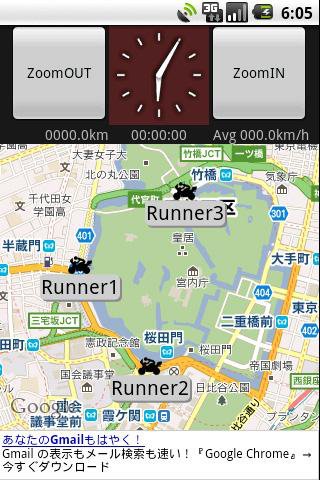
This application provides the location sharing service "Where everyone?".
"Where everyone?" is ability to understand each other, where you are now someone else on the map.
*** Let's try "Where everyone?" ***
Please push Menu button,
and tap the 'Where everyone?' button.
The Input dialog is displayed.
Input keyword 'test' and Tap 'OK' button.
The map is displayed, Please see aroud Tokyo Japan.
you can see 4 test runnners.
Like it? Share with your friends!
Supported operating systems:
Google Android 1.5, Google Android 1.6, Google Android 2.0, Google Android 2.1, Google Android 2.2, Google Android 2.3, Google Android 3.0, Google Android 3.1
Similar Software:
TomTom Mexico for Android TomTom Mexico for Android - TomTom Mexico is a turn-by-turn GPS navigator for Android devices. The app includes accurate offline maps, so you can find your way anywhere, even without an internet connection
CoPilot Live UK + Ireland (Android) CoPilot Live UK + Ireland (Android) - CoPilot Live is full-featured voice-guided GPS navigation with street maps of 1 European region stored on your Android phone. Includes 3D guidance, lane assist, speed limit warnings, safety camera alerts, planning mode.
Download maps via WiFi after purchase. Unlimited use after 10 days once Google order verified
ParkLeitSystem ParkLeitSystem is a car-park-routing system. It shows you, according to your GPS position, the nearest city with a car-park-routing system and gives you a list with all available car-parkings and shows how many free places there are. With a click on the parking it switches to google maps and shows you the position of the parking
GPS Status GPS Status is an application which displays the information received from the phone's GPS receiver. In addition to the basic location information it can extract and display the state and location of each visible GPS satellite which is displayed on a simple sky view. The outer circle represents the horizon while the center corresponds to the zenith right above your head
Connector - Track & Dispatch (Android) Connector - Track & Dispatch (Android) is a cloud-based, Google Apps integrated track and dispatch service.
The service supports a wide range of location-aware devices including smart phones, wireless routers and other GPS devices. It is suitable for businesses and organizations of all sizes as well as for individuals
My Tracks My Tracks - Use My Tracks while you run, bike, hike, or do anything else outdoors, and it will use the GPS sensor in your Android phone to record the path you took. It will also gather useful statistics such as time, speed, distance, and elevation. You can review all of this data live, or you can save it for use later
GPS2OpenGTS Free GPS2OpenGTS will send your GPS data to an OpenGTS tracking system.
Latest version now supports UDP.
Also added is a Test function/screen to help with server configuration.
Send a NMEA GPRMC strings with the following data.
(accountID, deviceID, Latitude, Longitude, Speed, Heading and Altitude
Satsports Log Satsports Log is your general sport app. Ideal for running, cycling, mountain biking, hiking and walking. It also has some fun visual features such as maps and graphs of your elevation, speed and pace. Real time Statistics: Satsports-log has all the stats you could wish
My place My place This application allows you to determine your current location and to share it with your friends by sms or e-mail, if you want or need this.
Also it is possible to share your location with other apps, which are already installed on your phone (Google maps, Twitter apps, notes, etc.)
Other Software by developer «kazuhito kawabe»:
not found
Comments on TouringNavigation:
Comments not found
If you noted an error or download link is broken, please, report it via this page or use comments.
TouringNavigation is compatible with your device Archos 32 Internet Tablet 8GB


")
")


")


