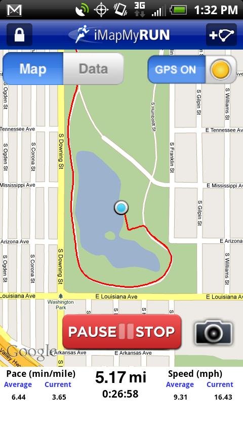
iMapMyRUN Run GPS Running Jog - iMapMyRUN+ tracks the route, distance, pace, and more in real-time using GPS.
Free new version!
iMapMyRUN+ brings you its mobile app for Android-based devices! Now owners of Android 2.1 or higher devices can track the route, time, distance, speed, pace and calories in real-time for their fitness activities using their GPS enabled mobile device.
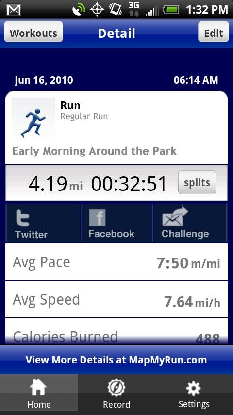
Your results sync with
www.mapmyrun.com
!
iMapMyRUN+ is great for fitness, jogging, weight loss, calorie counting, training, and more, and is an integral part of the MapMyRUN platform, by MapMyFITNESS.
Like it? Share with your friends!
Supported operating systems:
Google Android 1.5, Google Android 1.6, Google Android 10.x, Google Android 2.0, Google Android 2.1, Google Android 2.2, Google Android 2.3, Google Android 3.0, Google Android 3.1, Google Android 3.2, Google Android 4.0, Google Android 4.1, Google Android 4.2, Google Android 4.3, Google Android 4.4, Google Android 5.x, Google Android 6.x, Google Android 7.x, Google Android 8.x, Google Android 9.x
Similar Software:
Location Manager Location Manager - This unique location app is best described with the following scenarios:
Scenario 1:
I live in an area where the Oregon, California, and Santa Fe Trails all passed through. There are signs everywhere saying, "The trails crossed here"
GeoBeagle GeoBeagle is a free, open source application for the Android platform to aid users in finding geocaches and letterboxes. It enables the user to do paperless geocaching.
Geocaches and letterboxes are objects that have been hidden in the real world; the game of geocaching/letterboxing is finding these objects around you
iMapMyWALK+ iMapMyWALK+ - tracks the route, distance, pace, and more in real-time using GPS.
Free new version!
iMapMyWALK+ brings you its mobile app for Android-based devices! Now owners of Android 2.1 or higher devices can track the route, time, distance, speed, pace and calories in real-time for their fitness activities using their GPS enabled mobile device
GPS Status GPS Status is an application which displays the information received from the phone's GPS receiver. In addition to the basic location information it can extract and display the state and location of each visible GPS satellite which is displayed on a simple sky view. The outer circle represents the horizon while the center corresponds to the zenith right above your head
OpenGPSTracker OpenGPSTracker adds the capability to store and review where you and your Android device have been. Basically you press record at the start of your trip and your phone stores the route you take. This route is drawn real-time on the Maps functionality of Android or in the background with an idle device. The route is stored on your phone for review and further use
Automobile Locator This app has a rotating arrow that points in the direction of your car. It allows you to mark your cars location using GPS. You can then use it at a later time to help guide you back to where you parked
wheredroid wheredroid is a simple application to display your coordinates from the GPS receiver: latitude, longitude, heading, speed, number of satellites used and (it's its peculiarity) altitude and accuracy. It is quite usable as an altimeter and a compass.
What's New in This Release:
· fixes a bug inverting East with West on some displays
What's New in 1.4
Locate Resources Locate Resources - Why do you need Locate Resources application?
1. Locate Resources tracks, monitors and manages an individual or group of people for operational and safety security reasons.
How to start?
1. Install the application on your Android phone.
2. Create your account by providing your email id, phone number of the device, name, country and submit it.
3
SOS App SOS App - This app sends a text message with your GPS position (address from google maps, latitude, longitude and accuracy).The use is simple. You have to choose a contact (with the search button) and then touch the picture
GoPenS GoPenS is an OpenSource GPS application for Android phones, based on OpenStreetMap (OSM). OpenStreetMap is a collaborative map of the world. Therefore, one of the main functions of the application is to be able to record a trace and send it as a GPX to the OSM servers, and so edit the OSM Map
Other Software by developer «MapMyFitness Inc.»:
iMapMyWALK+ iMapMyWALK+ - tracks the route, distance, pace, and more in real-time using GPS.
Free new version!
iMapMyWALK+ brings you its mobile app for Android-based devices! Now owners of Android 2.1 or higher devices can track the route, time, distance, speed, pace and calories in real-time for their fitness activities using their GPS enabled mobile device
MapMyRIDE GPS Cycling Riding MapMyRIDE GPS Cycling Riding - tracks the route, distance, pace, and more in real-time using GPS.
NEW: iMapMyRIDE+ for Android
iMapMyRIDE+ brings you its mobile app for Android-based devices! Now owners of Android 2
iMapMyRIDE Riding Cycling GPS iMapMyRIDE Riding Cycling GPS - iMapMyRIDE+ tracks the route, distance, pace, and more in real-time using GPS.
NEW: iMapMyRIDE+ for Android
iMapMyRIDE+ brings you its mobile app for Android-based devices! Now owners of Android 2
iMapMyFITNESS+ Fitness App iMapMyFITNESS+ Fitness App - tracks the route, distance, pace, and more in real-time using GPS.
Free new version!
iMapMyFITNESS brings you its mobile app for Android-based devices! Now owners of Android 2.1 or higher devices can track the route, time, distance, speed, pace and calories in real-time for their fitness activities using their GPS enabled mobile device