EcoDrive Free Speedometer - EcoDrive Free Speedometer - accurate and convenient GPS speedometer.
The app is designed to control the speed, economy, time, direction, etc.
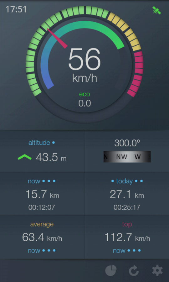
Real-time economy calculations is based on the speed, acceleration and braking, descents and ascents.
Flexibly adjustable speedometer scale allows to use the app on different types of transport: car, motorbike or bicycle, yacht or boat, and in any sports where is important speed, acceleration, time, etc.
All information about the speed, duration, acceleration and economy for different periods of time is saved and displayed in a convenient way.
Key features:
- Speedometer with flexible adjustable scale
- Determination of relative economy of movement
- Selection of units (U.S. and metric system of units)
- Audible alarm on exceeding the set speed (three adjustable parameters)
- Floating speedometer window on top of other apps
- Background work
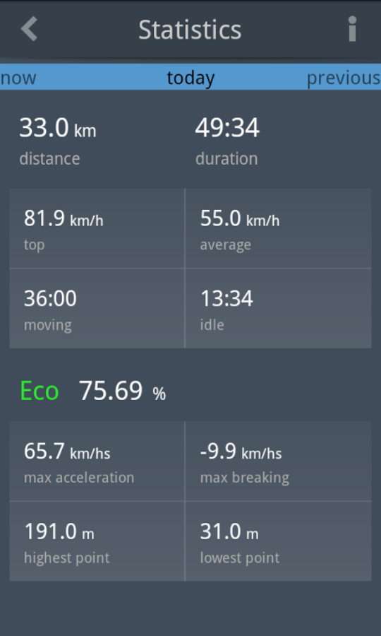
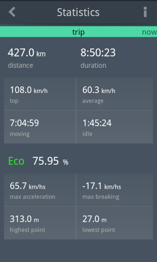
Statistics:
- Instantaneous, average and maximum speed for different periods of time
- mileage
- Duration of move
- Direction of movement (compass)
- Instantaneous and average economy
Supported operating systems:
Google Android 10.x, Google Android 2.2, Google Android 2.3, Google Android 3.0, Google Android 3.1, Google Android 3.2, Google Android 4.0, Google Android 4.1, Google Android 4.2, Google Android 4.3, Google Android 4.4, Google Android 5.x, Google Android 6.x, Google Android 7.x, Google Android 8.x, Google Android 9.x
Similar Software:
Osm2GpsMid GpsMid is a free, fully offline, vector based map application for your mobile phone. It displays your current position on a zoomable map and can be used to search for and navigate to roads or points of interest of your liking. As all data is stored in a compact binary format on your mobile phone you will incur no charges for extra data downloads
NAVIGON Europe for Android NAVIGON Europe for Android - NAVIGON turns your mobile device into a fully featured GPS navigation system. The software provides advanced functionality for both drivers and pedestrians, including 2D and 3D maps, route planner, speed assistant, voice directions, local search, and more
Android Photo GeoTag Android Photo GeoTag - Take pictures with your mobile phone and incorporate the data of the geographical location. The application allows you to include in the photographs, data from the GPS receiver, along with a brief note. If you know the coordinates, not having the GPS receiver, you can also handwrite geographic data
Weather Forecast USA Weather Forecast USA- Displays 7-day forecast for any location in US (Alaska, Puerto Rico, Hawaii and Guam included). Location is determined via GPS on your device, so don''t forget to turn it on. Forecast is obtained from NOAA web services where it is refreshed hourly
Current Location Finder Current Location Finder - Current Location finder which can be used to locate your location with the aid of a live satellite map you can dynamically (real time) determine ... Use the live satellite maps
Outdoor Share for Android Outdoor Share for Android - The Outdoor Navigation software is your best friend through your adventures in the wild.
Go into the outdoors with confidence and enjoy your activities without worrying about the tools to help you navigate. Your Outdoor Navigation app is made by the people who have been developing this software since 2003 across multiple platforms
NearMe NearMe application gives you a fast and easy way to find places near you. In addition, you can set the area (in Km) where to search. With every found place you have some useful options:
* Call
* Add To Contacts
* Open In Maps
* Get Directions
And other option is History: it keeps for you all places you have searched for
OpenGPSTracker OpenGPSTracker adds the capability to store and review where you and your Android device have been. Basically you press record at the start of your trip and your phone stores the route you take. This route is drawn real-time on the Maps functionality of Android or in the background with an idle device. The route is stored on your phone for review and further use
MySpeed MySpeed will record your speed and location to a log file and show it on a map.
It can use a database of speed camera locations to alert you when you're near a speed camera.
There is no speed camera database included. You'll need to download the data from a site such as scdb.info, flitspaal.nl, pocketgpsworld.com, maparadar.com, etc
Other Software by developer «JoyNow!»:
Ru-en phrasebook lite Russian - English phrase book needed by all who are traveling or studying English!
Rus-English phresebook lite The Russian-English phrasebook - is the one of the best phrasebooks for Android is designed for users who have a basic knowledge of English, and for those who does not speak English, for use in any travel and to learn English via more than thousand nine hundred phrases


")


