Outdoor Compass for Android - The Outdoor Navigation software is your best friend through your adventures in the wild.
Go into the outdoors with confidence and enjoy your activities without worrying about the tools to help you navigate. Your Outdoor Navigation app is made by the people who have been developing this software since 2003 across multiple platforms. Be sure that you will stay ahead of the rest with continuous updates and relevant tools.
It is an excellent tool for biking, jogging, skiing, hiking, geocaching, boating, flying and many other sporting activities.
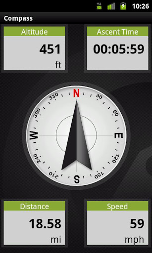
Your Outdoor Compass will give you the ability to view your headings using multiple elegant layouts to match your personality or your current activity. You may also change your layout to include a chart of your current track’s altitude, speed, or acceleration. In addition, you can also pick any 4 of 40 different data elements or trip tools to be viewed simultaneously while your compass is displayed in the center.
· Different layouts available beside the basic compass
· Possibility to view a chart
· Possibility to view and select Trip computers beside the Compass
Installation instructions:
Outdoor Compass is an add-on for the free Outdoor Navigation application. You need to have your Outdoor Navigation installed to be able to use Outdoor Compass.
Download and install Outdoor Compass on your Android device. Start the Outdoor Compass plugin to complete the license checking: when activation will be completed then the icon will be removed (you need to restart your device to hide the icon) and the plugin will be used inside Outdoor Navigation application.
What's New in This Release:
· Bug fixing
Like it? Share with your friends!
Supported operating systems:
Google Android 10.x, Google Android 2.1, Google Android 2.2, Google Android 2.3, Google Android 3.0, Google Android 3.1, Google Android 3.2, Google Android 4.0, Google Android 4.1, Google Android 4.2, Google Android 4.3, Google Android 4.4, Google Android 5.x, Google Android 6.x, Google Android 7.x, Google Android 8.x, Google Android 9.x
Similar Software:
Modern Compass Modern Compass this compass does what the compass always was intended to do, it helps you locate the destination of your choice.
Using GPS technology and Google maps, this application lets you mark a destination of choice and then shows in what direction that destination lies, as well as how far away it is from your current location
Garmin Mechanic Garmin Mechanic - Get insight into how your car is performing with the free Garmin Mechanic application. Use the Skidpad to measure lateral acceleration, and track your speed and distance using GPS.
Taking a trip? Garmin Mechanic tracks your trips and calculates total distance, average speed, and estimated mileage to help increase fuel savings
CompassPro CompassPro - Best Compass application for Android! Two fantastic compass styles to choose from.
You can have a compass icon always showing on your phone screen! The size and display area can be easily configured.
Note: You need to Calibrate the Sensor Compass first: Rotating your phone around all axes in a continuous movement
SharpSol Pedometer Free SharpSol Pedometer Free - Adjust settings first.
Air Push ads completely removed in this update.
Facebook posting bug removed
resting values dialog added.
Speach API working 100% accurate now.
No popup ads.
absolutely free with charts support.
Welcome to SharpSol Pedometer
Street Race Street Race - App for timing 1/4 mile runs and 0-60mph sprints. Upload your best timings and compare with results from other drivers.
Speedometer operates off phone GPS service. Accuracy is dependent on your phone and satellite reception.
To do a timing run, touch on of the buttons on the first screen
3D Compass (AR Compass) 3D Compass (AR Compass) - 3D compass with augmented reality view, Auto rotate map, Big heading degrees
This is a compass app with augmented reality view and real time map update, and provides real time location information
Point Lite Point Lite Want to know where you are relative to specific places important to you? Or where to go?Point shows it to you in one glance!Add your own points of interest. Mark your current spot before taking a stroll to easily find your way back.Or ask Point to give you a sign when you are near an important spot
Smart Tools Smart Tools is a complete package of 6 app sets. I
Super Swiss Army Knife Free Super Swiss Army Knife Free - This is a super software which has a multi-functional combination applying to life, travel and military combat. It is a veritable Swiss Army Knife with a cool widget desktop, including eight functions of ruler, protractor, flashlight, compass, gradienter, vertical, wall picture, telemeasurement
Other Software by developer «GPS Tuner»:
GPS Tuner Essentials Full Version with Brazil Basic Map Content GPS Tuner Essentials Full Version with Brazil Basic Map Content is designed specifically for off-road use: its large buttons, selectable tool window size, multiple Compass views and the built-in Tele Atlas map makes it extremely user-friendly and reliable
Outdoor Chart for Android Outdoor Chart for Android - The Outdoor Navigation software is your best friend through your adventures in the wild.
Go into the outdoors with confidence and enjoy your activities without worrying about the tools to help you navigate. Your Outdoor Navigation app is made by the people who have been developing this software since 2003 across multiple platforms
Outdoor Speedometer for Android Outdoor Speedometer for Android - The Outdoor Navigation software is your best friend through your adventures in the wild.
Go into the outdoors with confidence and enjoy your activities without worrying about the tools to help you navigate. Your Outdoor Navigation app is made by the people who have been developing this software since 2003 across multiple platforms
GPS Tuner Atlas Full Version with South America Basic Map Content GPS Tuner Atlas Full Version with South America Basic Map Content is designed specifically for off-road use: its large buttons, selectable tool window size, multiple Compass views and the built-in Tele Atlas map makes it extremely user-friendly and reliable
GPS Tuner Essentials Full Version with Baltic Basic Map Content GPS Tuner Essentials Full Version with Baltic Basic Map Content - is designed specifically for off-road use: its large buttons, selectable tool window size, multiple Compass views and the built-in Tele Atlas map makes it extremely user-friendly and reliable
GPS Tuner Essentials Full Version with Iberia Basic Map Content GPS Tuner Essentials Full Version with Iberia Basic Map Content is designed specifically for off-road use: its large buttons, selectable tool window size, multiple Compass views and the built-in Tele Atlas map makes it extremely user-friendly and reliable
US Terrain Intelligence for Android US Terrain Intelligence for Android - The Outdoor Navigation software is your best friend through your adventures in the wild.
Go into the outdoors with confidence and enjoy your activities without worrying about the tools to help you navigate. Your Outdoor Navigation app is made by the people who have been developing this software since 2003 across multiple platforms
GPS Tuner Essentials Full Version with Nordic Countries Basic Map Content GPS Tuner Essentials Full Version with Nordic Countries Basic Map Content is designed specifically for off-road use: its large buttons, selectable tool window size, multiple Compass views and the built-in Tele Atlas map makes it extremely user-friendly and reliable
Outdoor Share for Android Outdoor Share for Android - The Outdoor Navigation software is your best friend through your adventures in the wild.
Go into the outdoors with confidence and enjoy your activities without worrying about the tools to help you navigate. Your Outdoor Navigation app is made by the people who have been developing this software since 2003 across multiple platforms
GPS Tuner Essentials Full Version with British Isles Basic Map Content GPS Tuner Essentials Full Version with British Isles Basic Map Content is designed specifically for off-road use: its large buttons, selectable tool window size, multiple Compass views and the built-in Tele Atlas map makes it extremely user-friendly and reliable


")


