GPS Status & Toolbox - Be a GEEK: Get the most out of your phone. Raw GPS data at your fingertips.
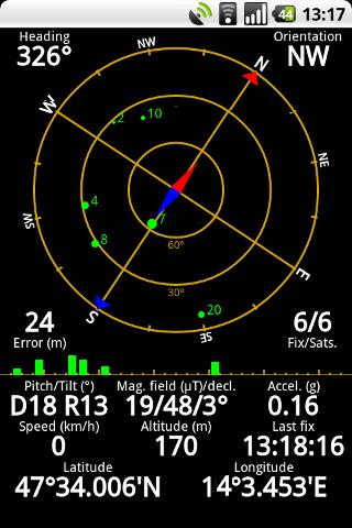
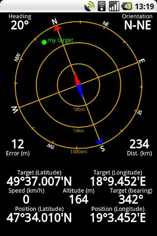
Display your GPS and sensor data: position and signal strength of satellites, accuracy, speed, acceleration, bearing.
Tools included: compass with magnetic and true north, leveling tool, mark or share your location and navigate back later.
Keep your GPS fast: reset it or download A-GPS data regularly for faster fixes.
What's New in This Release:
· Workaround for Nexus S issues.
· aGPS age is correctly displayed (in hours / days).
· Fixed a rounding error in location formatting.
· More instruments for Nexus 7.
· Enhanced landscape layout. All instruments are available in landscape mode, too!
Like it? Share with your friends!
Supported operating systems:
Google Android 1.0, Google Android 1.5, Google Android 1.6, Google Android 10.x, Google Android 2.0, Google Android 2.1, Google Android 2.2, Google Android 2.3, Google Android 3.0, Google Android 3.1, Google Android 3.2, Google Android 4.0, Google Android 4.1, Google Android 4.2, Google Android 4.3, Google Android 4.4, Google Android 5.x, Google Android 6.x, Google Android 7.x, Google Android 8.x, Google Android 9.x
Similar Software:
AugSatNav Walk AugSatNav is an augmented reality navigation system which overlays walking directions upon a live video feed of the path or road ahead.
With AugSatNav there is no need to follow instructions or interpret maps - you can simply find your way by walking along the route highlighted by a bright white line
GeoBeagle GeoBeagle is a free, open source application for the Android platform to aid users in finding geocaches and letterboxes. It enables the user to do paperless geocaching.
Geocaches and letterboxes are objects that have been hidden in the real world; the game of geocaching/letterboxing is finding these objects around you
POSIT POSIT (Portable Open Search and Identification Tool) is a Humanitarian Free and Open Source Software project to use the Google Android phone as a platform for mobile disaster management applications
GpsTicker Gpsticker is a program for outdoor orientation and navigation with GPS, it is best for hiking and biking. Maps are downloaded automatically from OpenStreetMaps, provided the Phone has an active internet connection
TomTom Europe for Android TomTom Europe for Android - TomTom Europe is a turn-by-turn GPS navigator for Android devices. The app includes accurate offline maps, so you can find your way anywhere, even without an internet connection
GeoPix GeoPix - Headed to work or class? Want your school's mascot or company logo to show up as your wallpaper, "abracadabra" style, just as you arrive? Simply choose an image from Myxer’s massive catalog of wallpapers, or grab one from your phone, set the address- and watch it "auto-magically" appear as you reach your destination
TeleNav GPS Navigator Get voice-guided GPS, maps, business listings and real-time traffic updates now!
TomTom Poland for Android TomTom Poland for Android - TomTom Poland is a turn-by-turn GPS navigator for Android devices. The app includes accurate offline maps, so you can find your way anywhere, even without an internet connection
OSMTracker for Android OSMTracker stands for OpenStreetMap Tracker. It allows you to track your journey and mark significant way points. Way points can be marked with a tag using a button, with a quick voice record, a text note or by taking a picture. The various button pages and layouts can be customized to suit your OpenStreetMap activities
Other Software by developer «EclipSim Bt.»:
Hungarian for AnySoft Keyboard Kenyelmesen, magyarul irhat az Anysoft Keyboard segitsegevel. Magyar billentyűzet kiosztas es szotar AnySoftKeyboard-hoz. FIGYELEM! Ez egy kiegeszitő, ami csak az eredeti programmal egyutt műkodik. Onalloan nem!


")


