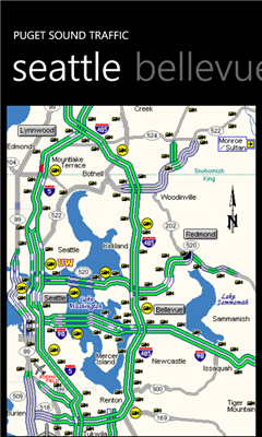
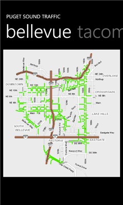
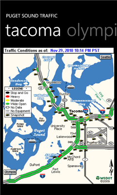
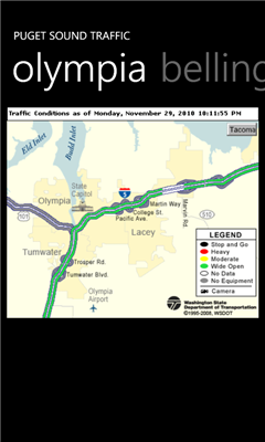
Puget Sound Traffic is a simple and quick way to view traffic conditions in the Puget Sound area.
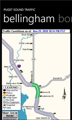
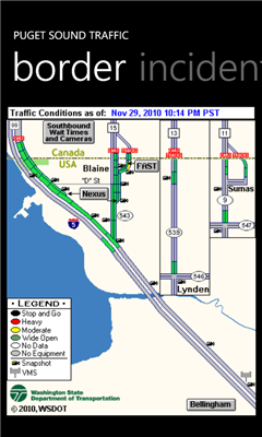
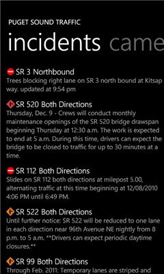
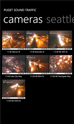
Maps are fetched from the Washington State Department of Transportation as well as other sites for Seattle, Bellevue, Tacoma, Olympia, Bellingham and the US/Canada border. Recent incidents from the WSDOT area also displayed.
Maps are not interactive. The maps are just the most recent images from the WSDOT.
Gently shake the phone to refresh the current view.
------
Version 1.2 makes adding cameras a bit easier. It also contains some bug fixes and performance enhancements.
Version 1.1 adds support for pinning your favorite traffic cameras to the cameras page. This version also adds a trial version which is ad supported. The paid version removes the ads.
Please visit http://www.straypixel.com for comments/suggestions.
Like it? Share with your friends!
If you got an error while installing Themes, Software or Games, please, read FAQ.
Supported operating systems:
Windows 10 Mobile, Windows Phone 7, Windows Phone 8
Similar Software:
MapStalt Mini MapStalt Mini is an application that is meant to bring the map to completeness. In the case of the open street map, many details are missing, and MapStalt puts to power to complete the map into the hands of the mobile user. With MapStalt, a user can add something as simple as a building address and latitude/longitude or complex details such as business hours of operation
Googlemaps Googlemaps - Enjoy Almost all features of Google Maps on your WindowsPhone7
Enjoy The Water-overlay mode, Physical mode, Hybrid mode, Satellite View, Street-View.
You can zoom in and zoom out without any Hindrance
FidMe FidMe - Toutes vos cartes de fidélité réunies sur votre mobile !
FidMe, le portecarte mobile pour vos cartes de fidélité !
Innovante et simple à utiliser FidMe : enregistrez vos cartes de fidélité en quelques secondes
Sun Locator Lite Sun Locator Lite - See a map of where the Sun is shining!
Sun Locator Lite displays a map showing the areas of night and day on the Earth. The map displays your current location and gives your current geographic coordinates.
No network coverage is needed to run this app
En Zaragoza En Zaragoza - Localiza cientos de lugares de interes de Zaragoza rapidamente a traves del mapa.
"En Zaragoza" es una aplicacion gratuita que permite localizar, mediante un mapa de la ciudad de Zaragoza, cientos de lugares de interes. Localiza centros de salud, estaciones Bizi, farmacias, parques, etc
GMap Pro GMap Pro - Ultimate Google Maps for Windows Phone 7
In new version we have added China region detection and offset auto correction. We have also improved navigation by adding auto rerouting and current step highlighting.
We appreciate your feedback. Help us make tool you’d like
Chicago Maps Chicago Maps - Offline (no data connection necessary!) public transportation maps for the Chicago area. Click on the thumbnails and zoom in for a detailed look.
Includes:
1. an overview of the Chicago Transit Authority system with the ability to zoom into different sections using a map and/or a list
2. Night Owl bus map
Can be used in portrait or landscape view
Canada Topography Canada Topography - provides topographic information for the entire country of Canada. The maps provide details such as altitude, railways and numerous other layers. Using the GPS you can center on your current location and even zoom to specific areas of the country.
All maps are provided by Geocratis Canada (http://www.geogratis.gc.ca/geogratis/en/service/toporama
Other Software by developer «Eric Davison»:
Leaderboard Leaderboard - Wondering who's leading at this week's tour stop? Fire up Leaderboard to get a quick view of the top 20 or so players. Tap the leaderboard to get a full, more detailed view.
Gently shake the phone to refresh.
http://www.straypixel