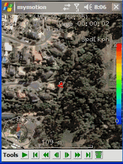
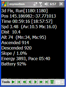
MyMotion - GPS route recording and playback with customizable spoken feedback of speed, distance and time. Uses a moving map to show progress as well as textual output. Maps can be generated from Google Earth installed on a PC using a map creation tool. Allows user to record a route then load it up as a reference for live comparison the next time it is traversed. Optional location tracking of GPS devices with GPRS or 3G, via the web and Google Earth or Google Maps.
· This software is free for personal use.
What's New in This Release:
· Performance Improvements, particularly UI responsiveness.
· User definable default file name format for track save.
· Add sensitivity enabling for menu items.
· Bug fixes: Fixed arrow direction. Fixed corruption with long (> 32 chars) file names in track files.
Like it? Share with your friends!
If you got an error while installing Themes, Software or Games, please, read FAQ.
Supported operating systems:
Windows Mobile 2003, Windows Mobile 5.0, Windows Mobile 6 Classic, Windows Mobile 6 Professional, Windows Mobile 6.1 Classic, Windows Mobile 6.1 Professional, Windows Mobile 6.5 Professional
Similar Software:
FON Access Points for Portugal FON Access Points for Portugal - FON offers you a new Points of Interest service (POIs). This allows you to download FONspots directly to your navigation device.
What does that mean? You can download a Points of Interest file directly to your navigation device
My Position My Position - With My Position it is possible to see actual GPS information via the phone's built in GPS and send the position to others via sms or email.
When sending the position via sms or email it is possible to enter a telephone number or email address. It is also possible to select a contact from the contact list
MapTexterer MapTexterer - MapTexterer allows you to create text based GPS maps. When you get a GPS lock then you can create a new map and enter text for the area. When you save the text the map is downloaded and the text and GPS is appended to the end of the map with current GPS.
This program requires that you have both the 'BeanDLL
uTrack uTrack - uTrack can be used to track mobile devices in a passive, non-intrusive way.
It can be used to publish the location of a Windows Mobile powered device to a widget that can be included in numerous websites including you're own. If a widget is not possible or more flexibility is required, uTrack can also be configured to publish directly to any website or webservice
gps2sms4poi66 gps2sms4poi66 - Freeware application for poi66.com service. It sends periodically your GPS coordinates using SMS ("GP Lat Lon") for tracking via webpage on poi66.com. You can edit smsto.txt which holds phone no's
PoliceGPSes PoliceGPSes - PoliceGPSes can be used to track suspects that you are using the PocketPC PoliceGPSer's locator on. You can make a file for each group of locators and view the current latitude/longitude/speed and altitude of each GPS locator on the Google.com maps site.
This program requires that you have both the 'BeanDLL
quoox|TRACKER quoox|TRACKER - quoox gps tracker is a free service to live-track any kind of things using gps technology. The only thing needed is a device, which uploads its current gps data to quoox tracker service periodically.
This service is completely free for private use and easy to use. Just register a tracker id, simple as that
Map Calibrator Map Calibrator - If you would like to calibrate maps on your desktop PC, use free Map Calibrator program. Map Calibrator is also useful to create map slices from a huge bitmap image file. You can convert GIF, BMP and PNG files into JPG file to use it in GPS Tuner as well
BikeTrack BikeTrack - This application enables everybody (who got your user/pass) look up your location on the net, using your the page http://fiets.galway.nl/ and keeps track of you.
On the webpage you can also create a username so you can use the software.
What it does:
- Gets location from GPS.
- Sends it to BikeTrack Server
PictureMapperer PictureMapperer - PictureMapperer can be used to tag pictures/videos from your camera with a Google.com map and GPS data. When the program detects a new picture/video in the folder then it downloads a Google.com map and appends it to the end of the image/video with GPS information
Other Software by developer «Ian Pendlebury»:
not found
Comments on MyMotion:
Comments not found
If you noted an error or download link is broken, please, report it via this page or use comments.
MyMotion is compatible with your device Asus Lamborghini ZX1