Outdoor Compass for Android - The Outdoor Navigation software is your best friend through your adventures in the wild.
Go into the outdoors with confidence and enjoy your activities without worrying about the tools to help you navigate. Your Outdoor Navigation app is made by the people who have been developing this software since 2003 across multiple platforms. Be sure that you will stay ahead of the rest with continuous updates and relevant tools.
It is an excellent tool for biking, jogging, skiing, hiking, geocaching, boating, flying and many other sporting activities.
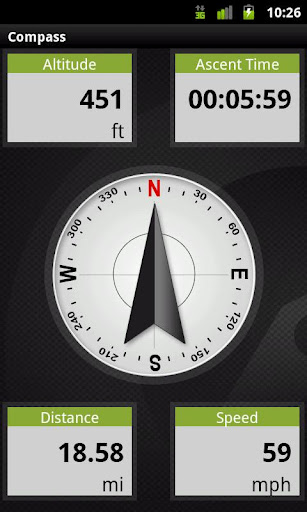
Your Outdoor Compass will give you the ability to view your headings using multiple elegant layouts to match your personality or your current activity. You may also change your layout to include a chart of your current track’s altitude, speed, or acceleration. In addition, you can also pick any 4 of 40 different data elements or trip tools to be viewed simultaneously while your compass is displayed in the center.
· Different layouts available beside the basic compass
· Possibility to view a chart
· Possibility to view and select Trip computers beside the Compass
Installation instructions:
Outdoor Compass is an add-on for the free Outdoor Navigation application. You need to have your Outdoor Navigation installed to be able to use Outdoor Compass.
Download and install Outdoor Compass on your Android device. Start the Outdoor Compass plugin to complete the license checking: when activation will be completed then the icon will be removed (you need to restart your device to hide the icon) and the plugin will be used inside Outdoor Navigation application.
What's New in This Release:
· Bug fixing
Like it? Share with your friends!
Supported operating systems:
Google Android 10.x, Google Android 2.1, Google Android 2.2, Google Android 2.3, Google Android 3.0, Google Android 3.1, Google Android 3.2, Google Android 4.0, Google Android 4.1, Google Android 4.2, Google Android 4.3, Google Android 4.4, Google Android 5.x, Google Android 6.x, Google Android 7.x, Google Android 8.x, Google Android 9.x
Similar Software:
3D Compass (AR Compass) 3D Compass (AR Compass) - 3D compass with augmented reality view, Auto rotate map, Big heading degrees
This is a compass app with augmented reality view and real time map update, and provides real time location information
Super Smart Compass 2 Super Smart Compass 2 - Super Compass is a basic compass application that shows you which direction your phone is pointed. You can use Compass in all outdoor activities as you can think about - walking, sailing, hiking, climbing, camping, flying, reading a map and so much more. Super Smart Compass is a traveler's best friends
Light Talk Light Talk - It's incredible! Light talk,a simple but useful,intuitive but magical android application which can make you cell phone into very useful tool as flashlight,spotlight,SOS,compass-light and so on.
Yes,the application supports, such as SONY Ericsson, HTC, Samsung, and MOTOROLA, almost all of the Android phone models
Obama Compass Obama Compass - The Obama Compass shows what direction your android phone is pointing and displays a picture of Obama in the center. The Obama Compass displays North, East, South, West and varying degrees. Also shows your heading
CompassPro CompassPro - Best Compass application for Android! Two fantastic compass styles to choose from.
You can have a compass icon always showing on your phone screen! The size and display area can be easily configured.
Note: You need to Calibrate the Sensor Compass first: Rotating your phone around all axes in a continuous movement
Street Race Street Race - App for timing 1/4 mile runs and 0-60mph sprints. Upload your best timings and compare with results from other drivers.
Speedometer operates off phone GPS service. Accuracy is dependent on your phone and satellite reception.
To do a timing run, touch on of the buttons on the first screen
Bubble Bubble- Over 2 million downloads! A bubble level. Hold any of the phone''s four sides against an object to test it for plumb/level, or lay it down on a flat surface for a 360° level
Elevation and Sea Depth Elevation and Sea Depth displays elevation and/or sea depth in direction of phone.In order to use it properly, hold your phone on flat surface and away from ferrous metal objects and electromagnetic fields
Other Software by developer «GPS Tuner»:
GPS Tuner Essentials Full Version with BENELUX Basic Map Content GPS Tuner Essentials Full Version with BENELUX Basic Map Content is designed specifically for off-road use: its large buttons, selectable tool window size, multiple Compass views and the built-in Tele Atlas map makes it extremely user-friendly and reliable
GPS Tuner Essentials Full Version with Iberia Basic Map Content GPS Tuner Essentials Full Version with Iberia Basic Map Content is designed specifically for off-road use: its large buttons, selectable tool window size, multiple Compass views and the built-in Tele Atlas map makes it extremely user-friendly and reliable
Outdoor Share for Android Outdoor Share for Android - The Outdoor Navigation software is your best friend through your adventures in the wild.
Go into the outdoors with confidence and enjoy your activities without worrying about the tools to help you navigate. Your Outdoor Navigation app is made by the people who have been developing this software since 2003 across multiple platforms
Outdoor SOS for Android Outdoor SOS for Android - The Outdoor Navigation software is your best friend through your adventures in the wild.
Go into the outdoors with confidence and enjoy your activities without worrying about the tools to help you navigate. Your Outdoor Navigation app is made by the people who have been developing this software since 2003 across multiple platforms
GPS Tuner Essentials Full Version with Canada Basic Map Content GPS Tuner Essentials Full Version with Canada Basic Map Content is designed specifically for off-road use: its large buttons, selectable tool window size, multiple Compass views and the built-in Tele Atlas map makes it extremely user-friendly and reliable
GPS Tuner Essentials Full Version with Balkans Basic Map Content GPS Tuner Essentials Full Version with Balkans Basic Map Content is designed specifically for off-road use: its large buttons, selectable tool window size, multiple Compass views and the built-in Tele Atlas map makes it extremely user-friendly and reliable
GPS Tuner Atlas Full Version with Full Europe Basic Map Content GPS Tuner Atlas Full Version with Full Europe Basic Map Content is designed specifically for off-road use: its large buttons, selectable tool window size, 6 different types of Compass views and the built-in Tele Atlas map makes it extremely user-friendly and reliable
GPS Tuner Atlas Full Version with South America Basic Map Content GPS Tuner Atlas Full Version with South America Basic Map Content is designed specifically for off-road use: its large buttons, selectable tool window size, multiple Compass views and the built-in Tele Atlas map makes it extremely user-friendly and reliable
GPS Tuner Essentials Full Version with Central Europe Basic Map Content GPS Tuner Essentials Full Version with Central Europe Basic Map Content is designed specifically for off-road use: its large buttons, selectable tool window size, multiple Compass views and the built-in Tele Atlas map makes it extremely user-friendly and reliable


")


