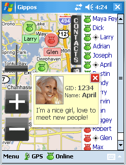
Gippos is mobile software for locating yourself and other users on the map and for instant messaging. Feel the city pace
Do you like to meet new people on the streets? Chat with them for free? Know where your friends are?
Meet and communicate without trouble! Enjoy nature
Arranging a picnic in a beautiful place? Inviting your friends for a country walk? Your friends will easily find you on a map!
· Find your friends on a map
· Meet new people around you
· Chat for free
What's New in This Release:
· Jabber protocol is used for messaging now.
· Jabber users from other servers can be added to contact list.
· Loading last messages to chat log window is added.
· Chat history viewing is added.
· Avatar loading is added.
· "About Gippos" info window is added.
· Maps switching logic is improved.
· Three modes of user's location visibility are implemented.
· New chat statuses are added.
· Gippos auto updating at new version release is added.
· "Don't turn the device off while the application is running" feature is implemented.
· Viewing user's location, history, and profile from chat window is added.
· Manually locating oneself on the map is added.
· Search window interface is changed
Like it? Share with your friends!
If you got an error while installing Themes, Software or Games, please, read FAQ.
Supported operating systems:
Windows Mobile 5.0, Windows Mobile 6 Classic, Windows Mobile 6 Professional, Windows Mobile 6.1 Classic, Windows Mobile 6.1 Professional, Windows Mobile 6.5 Professional
Similar Software:
SMSGPSer SMSGPSer allows you to create SMS contact number '.pgps' links and dial them via GPS distance. Select 'Start GPS' to get a GPS lock and create a new '.pgps' phone number. The program displays the distance between each GPS point and your current GPS. Tap on the link to start the built in SMS composer
CityGoogler CityGoogler uses the GPS on your PocketPC to find the 50 closest local business from 2,238 type of Yellow Pages entry sorted via GPS distance and stores the results into files based on store type. Tap the button to start the GPS and when you get a lock tap on it to view the list of local businesses. The GPS maps and business search service is provided by Google
TravelGoogling TravelGoogling allows you to use the GPS on your PocketPC to find 5,451 local stores and services in sorted via distance. Tap the button to start the GPS and when you get the lock tap the button to view the business directory. Tap on a business category to view local business listings. The GPS street information is from GeoNames
mdNavMobile mdNavMobile is a waypoint-based GPS navigation solution for the Windows Mobile platform. It can guide you from waypoint to waypoint while keeping you informed of all relevant navigation data. All NMEA-data from a GPS is automatically logged to file so you can 'replay' a trip with variable speed
Mobile Speedometer Mobile Speedometer - This application is part of the author's "30 Days of .NET" initiative to develop 30 mobile applications in 30 days. The source code of the application is included in order to help programmers new to Windows Mobile development write applications in .NET
FON Access Points for Uruguai FON Access Points for Uruguai - FON offers you a new Points of Interest service (POIs). This allows you to download FONspots directly to your navigation device.
What does that mean? You can download a Points of Interest file directly to your navigation device
Wizi Wizi is a free instant location sharing service which let you send your location to a friend via SMS or E-mail. Use Wizi to tell a friend where you are now or where you are going to meet. It uses your integrated or external GPS unit to find your location and show it on the map. If you have other friends using Wizi you can always find them on the map
FON Access Points for Monaco FON Access Points for Monaco - FON offers you a new Points of Interest service (POIs). This allows you to download FONspots directly to your navigation device.
What does that mean? You can download a Points of Interest file directly to your navigation device
GPSChannels GPSChannels can help you to get a better understanding of the best places to place your unit when trying to get a GPS fix. Start the program and it will display the NMEA logs and the total number of viewable satellites. You can also save the NMEA logs to a file
MapsAligner MapsAligner - MapsAligner allows you to download large maps based on your GPS or with custom latitude and longitude points that you enter. You can use this to compose maps for your GPS applications. The program uses the Google.com maps server for the maps.
This program requires that you have both the 'BeanDLL
Other Software by developer «Gippos»:
not found
Comments on Gippos:
Comments not found
If you noted an error or download link is broken, please, report it via this page or use comments.
Gippos is compatible with your device Asus MyPal A626