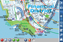
Rough Guides Map New York City... These guides are a series of fantastic interactive maps.
Produced in conjunction with the premier travel publisher Rough Guides.
Discover and explore New York City using full colour interactive linked maps, in this simple to use PDA version of The Rough Guides New York City.
Find all the top tourist spots and key attractions with ease, information on the city and its sights can be quickly displayed with links to photographs and map locations. All in a superb easy to use interface.
If you''re travelling to New York City, be sure you don''t leave home without this guide on your PDA.
The Rough Guide city maps includes:
Fully scrollable and interactive maps of the city.
Tap any location to display information and available links.
Intuitive navigation bar meaning you are never more than one click away from the information you require.
Map links allow you to directly link to other maps, photographs, or detailed views.
Categorised Find feature allowing you to quickly find any street, place of interest or station.
Categorised Information feature providing a wealth of information on the city, places of interest, etc.
1-Click Home feature, keeping the Home map always at hand.
Zoom function on all maps.
Special Offer Only $20.00
Hi Res & landscape displays supported.
Like it? Share with your friends!
If you got an error while installing Themes, Software or Games, please, read FAQ.
Supported operating systems:
Pocket PC 2002, Windows Mobile 2003, Windows Mobile 5.0, Windows Mobile 6 Classic, Windows Mobile 6 Professional, Windows Mobile 6.1 Classic, Windows Mobile 6.1 Professional, Windows Mobile 6.5 Professional
Map of Wisconsis (US State) Map of Wisconsis (US State) - A map of the Wisconsis by VITO Technology. Good for intercity travels with SmartMap.
SmartMap is a mobile device application which uses vector and raster maps. It is compatible with any NMEA protocol GPS receiver (Compact Flash socket, serial port, BlueTooth or sleeve)
MetrO (PPC) Metro helps you find your way in the public transport systems (subway, bus, trams, ...) in more than 4000 cities around the world. FREE, FAST & ACCURATE. Simply enter you start and end stops, hit the "Go" button and the program finds the fastest route
Map of Oman Map of Oman - A map of Oman, divided into 8 smaller territories for the ease of use.
MUSANDAM
AL BATINAH
AL ZANIRAH
MASQAT
AD DAKHILIYAH
ASH SHARQIYAH
AL WUSTA
ZUFAR
Good for intercity travels with SmartMap
Google Maps for mobile with Latitude Google Maps for mobile with Latitude is the official mobile mapping application from Google.
Features:
New! Google Latitude
Latitude lets you see your friends' locations and status messages. Share your location and status with select friends. Get started by selecting "Join Latitude" in the menu
Leicester Pocket A-Z Map Leicester Pocket A-Z Map - This publication has been designed for a Windows® Mobile-based Pocket PC (version 2002 or later) and the Pocket A-Z Viewer (included). The map covers an area of Leicester, extending to Anstey, Cropston, Rothley station, Syston, Scraptoft, Oadby, Wigston, Blaby, Narborough, Leicester Forest East, and Groby (part)
RideSchedulesCUMTD RideSchedulesCUMTD - The RideSchedules application is a full-featured public transit assistant that includes updatable schedules, countdowns, maps, favorite stops, directions, guides, tracking tools, alarms, announcements, parking meter, vehicle finder, realtime vehicle locations, offline support, and convenient access to transit provider services
TrackyPro (online GoogleMaps with GPS) TrackyPro - If you have taken your auto navigation system into the woods you probably realized that it becomes more of a paper weight than a navigation device. Without roads most cannot function. That is why you may need off-road navigation software
Rough Guides Map Rome Rough Guides Map Rome... These guides are a series of fantastic interactive maps.
Produced in conjunction with the premier travel publisher Rough Guides.
Discover and explore Rome using full colour interactive linked maps, in this simple to use PDA version of The Rough Guides Rome
Other Software by developer «Visual IT»:
Tube 2 Barcelona Pro (UIQ3) Tube 2 Barcelona Pro (UIQ3) - This map package for Tube 2 consists of a fully scrollable detailed map of the Barcelona metro & rail system and linked street maps of central Barcelona.
Plan journeys on the metro system, list details of the quickest routes and see a superb animated display of your journey tracking around the system map
Tube Seoul (Palm OS) Tube Seoul (Palm OS) - An award winning and highly acclaimed Palm OS application that guides you around the complex subway system of Seoul. An essential addition to your Palm device for locals and tourists alike.
Tube's features include:
A detailed clear colour (or grey scale) map of the transport system fully scrollable.
Quick find station utility
Tube 2 Brussels (UIQ) Tube 2 Brussels (UIQ) - This map package for Tube 2 consists of a fully scrollable detailed map of the Brussels tram, metro & bus system.
Plan journeys on these systems, list details of the quickest routes and see a superb animated display of your journey tracking around the system map
Tube 2 Atlanta (Palm OS) Tube 2 Atlanta (Palm OS) - This map package for Tube 2 consists of a fully scrollable detailed map of the Atlanta rail system.
Plan journeys on this system, list details of the quickest routes and see a superb animated display of your journey tracking around the system map
Tube Sydney (UIQ) Tube Sydney (UIQ) - Our award winning and highly acclaimed application guides you around the Sydney rail system is now available for your Symbian UIQ phone.
An essential addition to your P800 / P900 / P910 if you travel in or around this city
· A detailed clear colour map of the Sydney rail system fully scrollable.
· Quick find station utility
Berlin Metro 09 Berlin Metro 09 - The "Berlin Metro 09" application is a superb interactive map and route planner for the Berlin Metro (U-Bahn) and Suburban rail (S Bahn) systems. You can also use your inbuilt GPS (will also work with iPod Touch devices) to accurately locate and see the nearest transportation stop and distance to it
Tube 2 Munich (UIQ3) Tube 2 Munich (UIQ3) - This map package for Tube 2 consists of a fully scrollable detailed map of the Munich metro, rail & tram system.
Plan journeys on this system, list details of the quickest routes and see a superb animated display of your journey tracking around the system map.
Munich is the capital city of Bavaria, the southern most German federal state
London Central Bus 10 for iPad London Central Bus 10 for iPad - The new Zuti London Bus map has finally arrived, making it easy to travel by bus anywhere in central London. This clear and colourful map covers a detailed street level area of 6 miles by 4 miles and includes over 1300 bus stops and 189 bus routes
Tube 2 Barcelona (UIQ) Tube 2 Barcelona (UIQ) - This map package for Tube 2 consists of a fully scrollable detailed map of the Barcelona metro & rail system.
Plan journeys on the metro system, list details of the quickest routes and see a superb animated display of your journey tracking around the system map
London Visitors A-Z London Visitors A-Z - The London Visitors Map of central London is designed especially for the tourist. The principal feature of the mapping is the highlighting of places of interest, buildings open to the public, theatres, cinemas, selected shops and stores, main shopping streets, main line and underground railway stations and other locations of interest to the visitor


 Hi Res & landscape displays supported.
")
")
![USA-MT [Montana] Map for EagleEye PDA Tracking System](https://static.mobyware.org/data/images/def_program_reduced.png "USA-MT [Montana] Map for EagleEye PDA Tracking System")


")

")
")
")
")
")

")

")
