OrthoGraph Survey - The OrthoGraph Survey is a unique, pocket PC-based real estate surveying software that makes graphic ground-plan surveying easier, faster, and more accurate than ever before. It not only replaces paper-based assessment and data storage, it saves you time, labor and money.
Most Important Benefits of the Software:
* Time-saving surveying - You can conduct the survey three to four times faster than with the traditional method.
* Cost-efficient assessment - You can achieve up to 75% cost saving compared to the conventional surveying method.
* Outstanding productivity - Thanks to this fast and efficient survey, you will waste less time on the site.
* Labor efficiency - Even if the surveyor works individually, that is, without any aide, he or she can conduct the survey accurately and quickly.
* More orders for real estate surveying - Win your customers' confidence and loyalty with fast and accurate work, using our state-of-the-art solution.
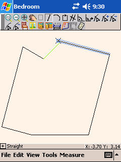
* Electronic ground-plan right on the site - The electronic drawing of the ground-plan is made right on the site on the basis of the survey. The drawing is compatible with almost all CAD and CAFM systems.
* Controlled data entry - Any omissions or inaccurate data can be detected right on the site, thereby identifying the need for measurements or control measurements.
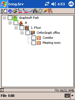
* Easy review of the data - The process of real estate surveying is easily reviewable thanks to the structured data handling. During the work process, the PDA always shows the important details, and thus ensures good reviewability despite the small size of the device.
* Accuracy - Precise, detailed surveying of small details, rooms, and even larger industrial buildings. Assess as much data as necessary.
And many more...
* Team work support - Several surveyors can work independently on different parts of a real estate. The team work support feature enables the easy handling of even large quantities of data.
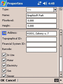
* No need for additional assessments - You can record controlled information right on the site: you can employ type, key, and mandatory fields and fixed lists. Eliminates burdensome and costly added assessments.
* Estimation of wall finishing materials - You can get accurate information right on the site about the quantities of each covering material required.
* Support of laser distance recorder - The software fully supports the Leica Disto A6 manual laser distance recorder, which is equipped with Bluetooth technology, enabling (thanks to wireless data gathering) faster and more accurate work than traditional surveying.
* CAD and CAFM support - Almost all architectural CAD systems are supported by the software, including ArchiCAD, AutoCAD, and Allplan CAD, as well as the ArchiFM facility management software.
* Outstanding flexibility - You can use an industrial or manual distance recorder, or even a measuring tape, for the surveying.
· 30 days trial
Like it? Share with your friends!
If you got an error while installing Themes, Software or Games, please, read FAQ.
Supported operating systems:
Windows Mobile 5.0, Windows Mobile 6 Classic, Windows Mobile 6 Professional, Windows Mobile 6.1 Classic, Windows Mobile 6.1 Professional, Windows Mobile 6.5 Professional
Similar Software:
PDFJPGFiles PDFJPGFiles - PDFJPGFiles converts a single JPEG file into a PDF file. Tap the button to open the dialog to select the JPEG file to convert. The program will then convert the JPEG file into a PDF V1.0 file. You can also preview the PDF file. The PDF libraries are from JPEG2PDF by Hao Hu 2008
DrawingGPS DrawingGPS allows you to create/view and edit bitmap drawings with a GPS stamp. The program has several features you can use to view the distance of each drawing and view on the Google.com maps. The map service is provided by Google
DrawingGPSeds DrawingGPSeds allows you to create/view and edit 256 colour bitmap drawings with a GPS stamp. The program has several features you can use to view the distance of each drawing and view on the Google.com maps. The map service is provided by Google.com. The 24-Bit -> 8-Bit bitmap conversion from the libraries originally created by Ephraim Cohen 1996
Amus'Art Amus' Art is a graphic software that makes it possible to write notes or to make color drawings
DrawingTimeds DrawingTimeds allows you to create JPEG drawings with a date and time stamp as the file name. You can browse the storage card of your PocketPC and create a new JPEG image. You can also edit the older images. The JPEG libraries are from Independent JPEG Group
DrawingGZIPed DrawingGZIPed allows you to create 'numbered' bitmap drawings that are compressed and uncompressed into GZIP files. You can browse the storage card of your PocketPC and create a new bitmap image. You can also edit the older images. The GZIP compression/decompression is from Gzip
Canvas - Smart Business Apps Canvas eliminates out-of-date, costly, paper based forms and transforms them into do-it-yourself applications for your Smartphone. Choose from pre-built applications in our App Store, which can be customized to your specific business or build your own application from scratch in just minutes
Spb Imageer Spb Imageer is a very powerful imaging engine designed specifically to streamline common processes that Pocket PC users perform with digital photos. Equipped with an incredibly rich set of features, Spb Imageer will make your work with images fast, comfortable and joyful. Even if you edit an 11 megapixels photo!
Spb Imageer features:
NEW! Uploading to flickr
SapphireJPG The Sapphire JPG utility provides the Visual Studio developer with the ability to convert .bmp bitmap image files to .jpg JPEG files.
Product Features
The Sapphire JPG Utility makes bitmap conversion easy with the following features:
Convert .bmp to
ImagedCamera ImagedCamera - ImagedCamera allows you to add timestamps to photos captured with your phone's camera.
Before taking a photo, you can set the resolution of the image. When you shoot a picture, the app will add the current date to the image, and save the photo in the current folder
Other Software by developer «OrthoGraph»:
OrthoGraph Architect OrthoGraph Architect - OrthoGraph Architect is a stand-alone PDA-based Building Survey software designed for on-site surveying of flats, houses having less than 50 rooms.
Easy to use sketching and measurement interface of creating floor-plans on-site using a PDA. Measure a room in seconds or a whole flat in minutes using OrthoGraph Architect
OrthoGraph Architect (iPad) OrthoGraph Architect (iPad) - OrthoGraph is the only CAD application for the iPad that lets users sketch and then create a survey for the production of detailed floor plans with continuous graphic feedback on the fly
OrthoGraph Inventory OrthoGraph Inventory - The OrthoGraph Inventory is a flexible inventory software system that runs on PDA and enables easy and fast inventory of your assets and stocks. Also, the system supports bar code scanners.
You no longer need to handle long lists or use considerable resources for on-site assessment or subsequent data recording

.jpg "Asus P526 (Pegasus)")


")
