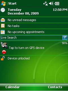
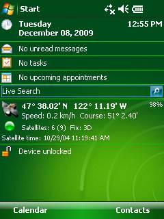
GPS2day is a today screen plug-in showing your current GPS coordinates, speed, satellite info, etc... Languages: English, Czech, Dutch, French, German, Hungarian, Italian, Japanese, Polish, Russian, Spanish.
Currently GPS2day program works as GPS informer. It supports both metric and U.S. (Imperial) units and shows a various types of information for users, such as:
Current geographical coordinates (latitude, longitude);
Course and speed;
Some information about satellites and fix type;
Altitude followed by the fix 3D value;
Exact current date and time from the satellite atomic clock;
And battery life state which is important when you using GPS device.
What's New in This Release:
· Translation to Japanese was added
Like it? Share with your friends!
If you got an error while installing Themes, Software or Games, please, read FAQ.
Supported operating systems:
Windows Mobile 5.0, Windows Mobile 6 Classic, Windows Mobile 6 Professional, Windows Mobile 6.1 Classic, Windows Mobile 6.1 Professional, Windows Mobile 6.5 Professional
Similar Software:
Tube London (2009 Edition) Tube London (2009 Edition) - Tube London
The ideal map for the traveller who needs to get around London using the underground system and would like to know just exactly where they are.
The map geographically locates all the central stations, making it much more informative than the official topological map
amAze (Samsung) AmAze is a first of its kind free navigation and local search service. It is free to download and use and it contains wide coverage of maps including aerial photo in Europe, North America, Australia and parts of Asia and Africa
Pilot My-Cast by Garmin Pilot My-Cast® by Garmin makes it easy to page through surface meteorological reports, terminal forecasts, observations and advisories instantly as they become available
Map of New Mexico (US State) Map of New Mexico (US State) - A map of the New Mexico by VITO Technology. Good for intercity travels with SmartMap.
SmartMap is a mobile device application which uses vector and raster maps. It is compatible with any NMEA protocol GPS receiver (Compact Flash socket, serial port, BlueTooth or sleeve)
redBANG Shenzhen Map-Guide NEW 2006 THE BEST MOBILE GRAPHICS YOU HAVE EVER SET YOUR EYES ON
This City map-Guide contains all THE TOP locations at your finger tips. Simple and easy to use, simply zoom in & out of this jpg map or move N, E, S or West
GPSLogGoogle Follow the route you have taken on Google Earth using the log made by your PocketPC
redBANG Shenzhen 18 TOP SIGHTS 2006 THE BEST MOBILE GRAPHICS YOU HAVE EVER SET YOUR EYES ON
This TOP 18 sights map contains all THE TOP locations at your finger tips. Simple and easy to use multi step zoom in & out function map as well as movement in any direction
Google Maps for mobile with Latitude Google Maps for mobile with Latitude is the official mobile mapping application from Google.
Features:
New! Google Latitude
Latitude lets you see your friends' locations and status messages. Share your location and status with select friends. Get started by selecting "Join Latitude" in the menu
SmartCaddie Pro SmartCaddie Pro with GPS
Thousands of courses, if your course is not there we will simply add it for you
12 players or more, special versions are available for leagues.
Includes enrolment for one user in the Nova Golf Internet Network (NGIN) providing further features and functions
Other Software by developer «Soft Expanse Group»:
ShellSwitcher ShellSwitcher was implemented as a Windows Mobile system utility for fast switching between well known shells: Spb Mobile Shell, Titanium (WM6.5 default shell), Touch Flo 3D, HTC Sense and classic Today screen. This application is based on UI Switcher knowledge with some additional features


")
")

")

![USA-MO [Missouri] Map for EagleEye PDA Tracking System](https://static.mobyware.org/data/images/def_program_reduced.png "USA-MO [Missouri] Map for EagleEye PDA Tracking System")


