GPSToday-GeoTerrestrial GPSToday now brings an unbeatable combination of location features to your mobile device.
Driving/Walking directions in many countries, with traffic-optimization option.
Log file plotting on map and animated "playback". Also, the geologger will now never clip corners, and will perfectly follow loopy highway ramps. You can now also upload your log-files to the desktop website.(full-featured log-editing on the desktop coming soon)
Location Tracking and sharing (GeoLocation). Track your location history online for your own private use, or share with friends/family. The power-saving ability of GPSToday means you can leave it on indefinitely without worrying about the battery.
Easily and privately (or publicly) share points-of-interest, pictures, messages with like-minded folks (GeoGroups). eg. Track or update swine-flu locations, right from your phone. The possibilities are endless.
'Slideshow' through all your address-book contacts on the map, or through driving directions, or local search results, or all friends' mobile locations
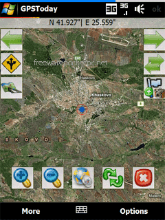
Satellite,Hybrid map views, and many more enhancements for ease of use.
Nearly worldwide support for many features that were previously US only.
Essentially the works, all in a still small package. More features are listed below the screenshots.
This software will not work on OS older than Windows Mobile 5.0 versions, or on any non-touchscreen smartphone. Data plan is recommended for online map features, but not necessary for offline features like geologging or geotagging. An Integrated GPS is advisable (but not mandatory) to fully enjoy the software.
Like it? Share with your friends!
If you got an error while installing Themes, Software or Games, please, read FAQ.
Supported operating systems:
Windows Mobile 5.0, Windows Mobile 6 Classic, Windows Mobile 6 Professional, Windows Mobile 6.1 Classic
Similar Software:
SmartCaddie Pro SmartCaddie Pro with GPS
Thousands of courses, if your course is not there we will simply add it for you
12 players or more, special versions are available for leagues.
Includes enrolment for one user in the Nova Golf Internet Network (NGIN) providing further features and functions
Route Tracker Route Tracker - With Route Tracker you can create routes and add several route points containing text and/or images from your current position. If GPS is available it will take the current longitude, latitude and altitude. Without a GPS module information of the current cell id and the location area code are saved
JVTrip JVTrip - Track yourself while you are on a trip, walking, cycling, driving or just watch your child move. And then export the path to Google Earth.
You can add notes, costs or pictures to your path. This information will be stored with the GPS location where you added them. When you export your track to Google Earth, all information will be there as markers
NoteGPSeds NoteGPSeds - NoteGPSeds is a full-featured voice/drawing note GPS editor/viewer. When you create a new note the current GPS is appended to the end of the file. You can view the files and edit them or edit the file and update it with your new GPS location.
This program requires that you have both the 'BeanDLL
PDA Navigation PDA Navigation - Simple navigation tool for Pocket PCs with GPS support.
· compass rose
· GPX tracking
· sun rise and set calculation
· export to LOC, GPX, KML
· import from GPX and LOC
What's New in This Release:
· Changed a lot of small things and corrected some errors
3dtracking 3dtracking has revolutionized the tracking industry through the launch of it's PDA tracking software. Any Windows-based PDA (with access to an internal or external GPS receiver) can be tracked using the 3dtracking PDA software
TravelGPSs TravelGPSs - TravelGPSs can be used when you travel. You can update your friends/family online via FTP server. The program creates a webpage with a live.com map link of your GPS location and notes on your trip.
This program requires that you have both the 'BeanDLL.dll' file ** and ** the runtime files for Visual Basic on your PocketPC computer
FON Access Points for Dominican Republic FON Access Points for Dominican Republic - FON offers you a new Points of Interest service (POIs). This allows you to download FONspots directly to your navigation device.
What does that mean? You can download a Points of Interest file directly to your navigation device
gpsVP gpsVP - GPS navigation software for Windows Mobile devices. It shows vector and raster maps, records and shows tracks, shows multiple navigation parameters, manages and shows waypoints. It aims to be as usable as possible
AlarmGPSs AlarmGPSs - AlarmGPSs uses the GPS on your PocketPC as a proximity alarm. When you start the GPS the program tracks your home location. You can set a distance range and when the PocketPC is moved past the distance then the alarm sounds.
This program requires that you have both the 'BeanDLL.dll' file ** and ** the runtime files for Visual Basic on your PocketPC computer
Comments on GPSToday:
Comments not found
If you noted an error or download link is broken, please, report it via this page or use comments.