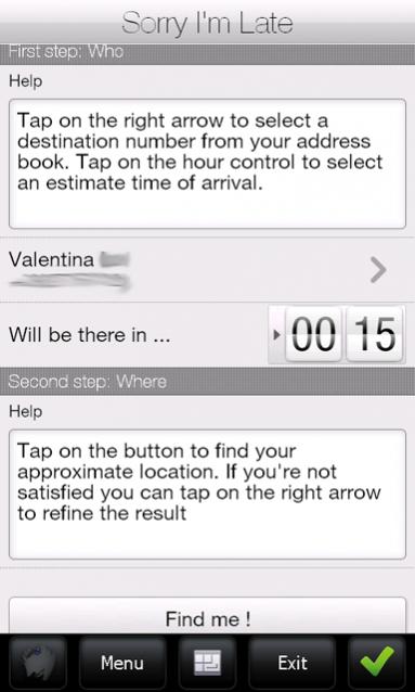
Sorry I'm Late - People are always in a hurry to get somewhere. A common issue is to inform someone waiting for us that we are, let’s say, a bit late and maybe reassure him that we will be there in some time. It would be great if we could send a message to that someone telling him our approximate location and an estimate time to reach the destination (maybe along with some excuses).
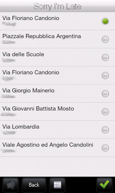
Sorry I'm Late was developed to achieve this task. This application allows a user to get his approximate location and then send it to someone else through an SMS. It has a friendly user interface and uses CellID localization instead of GPS. Also, it sends a more human readable message, unlike other similar applications which use GPS positioning to get a precise localization but then they send Latitude and Longitude coordinates or Google Maps links. This application uses street names instead of coordinates.
· Doesn't require GPS antenna
· Finger friendly UI thanks to SenseSDK from Steady Software
· Call history access to guess the most probable recipients
· Native SMS application used to send message to allow last minute changes
· Currently localized in English and Italian
What's New in This Release:
· added compression support on network calls to reduce bandwidth usage
Like it? Share with your friends!
If you got an error while installing Themes, Software or Games, please, read FAQ.
Supported operating systems:
Windows Mobile 5.0, Windows Mobile 6 Classic, Windows Mobile 6 Professional, Windows Mobile 6.1 Classic, Windows Mobile 6.1 Professional, Windows Mobile 6.5 Professional
Similar Software:
FON Access Points for Taiwan FON Access Points for Taiwan - FON offers you a new Points of Interest service (POIs). This allows you to download FONspots directly to your navigation device.
What does that mean? You can download a Points of Interest file directly to your navigation device
SMSGPSing SMSGPSing allows you to send your GPS location readings and a Google.com map link to a person via SMS
FON Access Points for Zambia FON Access Points for Zambia - FON offers you a new Points of Interest service (POIs). This allows you to download FONspots directly to your navigation device.
What does that mean? You can download a Points of Interest file directly to your navigation device
hdSpeedo hdSpeedo is a speedometer that is driven from a GPS signal.
· User configurable background colours
· Day/Night colour schemes (Choose by clicking on the top status bar)
· Rotatable (Portrait or Landscape)
· Gesture enabled (Move between screens)
· Point and Track logging now available as
NoniGPSPlot NoniGPSPlot allows you to locate your position in relation to other GPS points and to see the journey you have made.
It may be used to find your starting place in a port after sailing, or the place where you start a walking or biking excursion, or even your car in a parking. Any place long as you know its GPS coordinates.
It stores the whole journey too
MyGPS_PDA MyGPS_PDA - MyGPS_PDA is a light MyGPS version for PocketPC systems. It reads the NMEA sentences coming from a GPS antenna connected to the PocketPC and shows your position on a MyGPS calibrated map. The program can also store on a file the track log together with specific waypoints created by the user
NoniGPSPlot Pocket PC NoniGPSPlot allows you to locate your position in relation with other GPS points, to see the journey you have traveled.
You can find back your place at harbour after a trip on boat, the starting point of an excursion or locate your car in a huge car park, A place of which you know the location, To see the excursion you made, Speed trap alert or lots of other things..
CellGPSing CellGPSing uses the cellular signal on your device to instantly find your approximate GPS and display on a Google.com map. Tap the button while your phone is on and the program will send your cellular tower information to OpencCellID.org. The program will then display the approximate GPS. This service is provided by OpenCellID
FON Access Points for French Polynesia FON Access Points for French Polynesia - FON offers you a new Points of Interest service (POIs). This allows you to download FONspots directly to your navigation device.
What does that mean? You can download a Points of Interest file directly to your navigation device
AgMapper AgMapper - Create maps using your Windows Mobile device. Measure lengths and view areas without the desktop PC.
AgMapper makes it easy to map what ever you like and share it with other software packages by using the very common shape file format (.shp) to store your mapping data.
Load images onto your map created using the FREE AgMapper Image Converter
Other Software by developer «ste09»:
Mobile First Aid Mobile First Aid - According to a recent study (Gray, 2008) there are abount 1.8 mobile phones per person around the world. Since everyone of us can find himself in the need to give some first aid assistance to someone injured, it is simple to merge these two data and say "why don't give these people a first aid application to be installed on their mobile phones