Categories: Internet & Communications, Travel & Navigation
Upload date: 16 Jul 11
Developer: Dave McKellar
License: Freeware
Downloads: 15794 File Size: 123 Kb
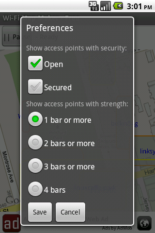
Wi-Fi Map Maker is application makes a map of Wi-Fi access points as you walk around.
· Maps out the actual coverage of each access point!
· Access point names are displayed on the map
· See street address and area of access points
· You can select the criteria for inclusion on your map.
· Info is saved in a database on your phone
· Supports landscape and portrait
· If hot spots overlap the strongest is put on top
What's New in This Release:
· More exit options
What's New in 1.3.6:
· Faster startup
· New option to follow your current location on the map
· You can hide the Pause/Record button so its not pressed accidentally
· App is slightly smaller (because ad code is now smaller)
What's New in 1.3.4:
· Prettier dialogs
Like it? Share with your friends!
Supported operating systems:
Google Android 1.5, Google Android 1.6, Google Android 10.x, Google Android 2.0, Google Android 2.1, Google Android 2.2, Google Android 2.3, Google Android 3.0, Google Android 3.1, Google Android 3.2, Google Android 4.0, Google Android 4.1, Google Android 4.2, Google Android 4.3, Google Android 4.4, Google Android 5.x, Google Android 6.x, Google Android 7.x, Google Android 8.x, Google Android 9.x
Similar Software:
OpenStreetMapViewer OpenStreetMapViewer provides Tools / Views to interact with OpenStreetMap-Data
MapDroyd MapDroyd - Of course, today there are many Android application featuring street maps. Most of them are based on Google Maps, which means you've to enable your mobile device's network connection through a GPRS or Wifi connection
NavStarter NavStarter is a little app that can be used for the Google Navigation Hack to navigate to an address without first creating a shortcut
MAPS.ME for Android MAPS.ME for Android - MapsWithMe allows you to access maps of all the countries in the world while on the go. The maps are based on OpenStreetMap data and work completely offline, without requiring an internet connection
TripComputer TripComputer is a personal off-road GPS navigation utility software for Android phones, that has been created for active people, who love travel by hike or bike.
The application does not use Internet connection or Google Maps for navigation or track recording, but you can share your data to others, or store your data on server
Modern Compass Modern Compass this compass does what the compass always was intended to do, it helps you locate the destination of your choice.
Using GPS technology and Google maps, this application lets you mark a destination of choice and then shows in what direction that destination lies, as well as how far away it is from your current location
Street View on Google Maps Street View on Google Maps - New! Street View smart navigation -- move around by dragging "Pegman" where you want to go. Try Street View on Google Maps to view street-level imagery from your phone. To use Street View, open Google Maps, search for a place or long-press the map, and tap the Street View option
NAVIGON MobileNavigator NAVIGON MobileNavigator - Turn your Android phone into a mobile navigation device with lots of useful functions that will delight you! The pocket navigation device will show you the right way with functions such as Reality View Pro and Lane Assistant Pro
flea papa flea papa Care about your communities by knowing what people near you are thinking, saying, doing, selling, wanting and needing. With a patent-pending Search By Route technology, you can also connect with people or objects of interest along travel routes when you are on a trip
Other Software by developer «Dave McKellar»:
XBMC Server - Free Let your friends select the music that plays on your mobile phone!
Dividend Predictor - Free Dividend Predictor - For the dividend investor.
Enter the symbols of stocks you own, the application looks up the details online and shows what future dividends you'll get.
Do you have a mix of regular stocks that pay quarterly and ETFs that pay monthly? -- no problem.
Or for "what if", enter stocks you might want to buy and see how they pay
TTC Subway Rider Efficiency Guide TTC Subway Rider Efficiency Guide - This application has maps of all TTC (Toronto Transit Commission) subway stations so you can see where the stairs/etc are... and plan where to stand on the platform.
Based on ttcrider.ca
Useful for handicapped people too
HashPost - Free HashPost - Free - A special purpose Twitter application. Its sole purpose in life is to make it easy for you to include #lots of #hashes in your Tweets. Ideal for Live Tweeting an event.
Profile Hashes:
· Enter them once and they are always included
Hockey Team Hockey Team - For the coach or captain of a recreational hockey team.
Given the number of players who showed up in the dressing room... how many forwards and how many defense is that?!
Also suggests how you might divide up your forwards.
Language is gender-neutral so you can use it for girls/women teams too.
Please note: this application is *not* a game