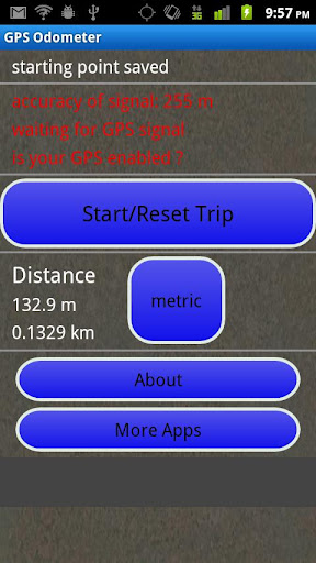
GPS Odometer - A simple and easy to use odometer. There is no maze of menus and no mysterious settings. GPS Odometer only does one thing, and does it well: measure distance traveled.
Note: Intended to measure relatively short distances, the application does not run in the background.
Like it? Share with your friends!
Supported operating systems:
Google Android 1.6, Google Android 10.x, Google Android 2.0, Google Android 2.1, Google Android 2.2, Google Android 2.3, Google Android 3.0, Google Android 3.1, Google Android 3.2, Google Android 4.0, Google Android 4.1, Google Android 4.2, Google Android 4.3, Google Android 4.4, Google Android 5.x, Google Android 6.x, Google Android 7.x, Google Android 8.x, Google Android 9.x
Similar Software:
Track My Mobile Track My Mobile - Your mobile phone can be Tracked by this applicatio after it get lost
Date Me Date Me uses GPS to determine your exact location and instantly connect you with fun friends in your immediate vicinity
TomTom Canada & Alaska for Android TomTom Canada & Alaska for Android - TomTom Canada & Alaska is a turn-by-turn GPS navigator for Android devices. The app includes accurate offline maps, so you can find your way anywhere, even without an internet connection
GPS Share GPS Share Have you ever been trying to meet friends in a large public space, but been unable to find each other? GPS Share was created for just such a scenario.
Use GPS Share to share your location how you want, whether it’s SMS, Email, Twitter, or something else. Because GPS Share uses no external services besides Google Maps, your privacy isn’t a concern
uWho Find Me uWho Find Me will send a text message with your current location to help people find you.Simply have your friend or family member send you a text with your uWho Find Me Access code as the body of the text and your current location will be sent back.
Notes:
Application runs on phone boot up
AugSatNav Walk AugSatNav is an augmented reality navigation system which overlays walking directions upon a live video feed of the path or road ahead.
With AugSatNav there is no need to follow instructions or interpret maps - you can simply find your way by walking along the route highlighted by a bright white line
BeBack Light BeBack Light - A GPS tracking and voice navigation utility economizing the battery charge.Suitable for hunters, fishers or other adventure finders: allows to walk straight to the target point with free hands according to the voice pointers, having your PDA in a pocket with the switched off screen and saving the battery charge on the way
MySpeed MySpeed will record your speed and location to a log file and show it on a map.
It can use a database of speed camera locations to alert you when you're near a speed camera.
There is no speed camera database included. You'll need to download the data from a site such as scdb.info, flitspaal.nl, pocketgpsworld.com, maparadar.com, etc
Locate My Family Locate My Family - Why do you need Locate My Family application?
1. Locate My Family tracks, monitors and manages an individual or group of people for operational and safety security reasons.
How to start?
1. Install the application on your Android phone.
2. Create your account by providing your email id, phone number of the device, name, country and submit it.
3
DroidTracker DroidTracker allows Android device users to share their exact location (using readable address and google map link) using SMS, Mail and Twitter.
· Contacts send a request SMS to your phone and receive your location back (once or periodically)
Other Software by developer «TappiApps»:
My GPS Coordinates and Location My GPS Coordinates and Location - A simple application with crude, but adequate, support for 40 languages. Allows you to share your position via email, text message, twitter, etc, and displays your current GPS location in both decimal format and in sexagesimal (degrees minutes seconds) format. Internet access is not required to send your location with a text message
GPS Tape Measure GPS Tape Measure - GPS Tape Measure is a virtual tape measure for your Android device. Perfect for when you want to easily find the distance between two points on earth and you forgot to bring your laser rangefinder. Simple and easy to use
Name That Plane Name That Plane - Test your knowledge of aircraft. The app features over 300 aircraft images. Compete with your friends and the world via a global score board provided by Scoreloop.
How score is calculated:
score = (percentage_correct * 10) / sqrt(sqrt(time_in_seconds))
Note that only thinking time is considered