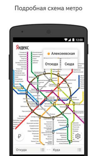
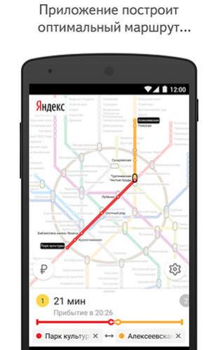
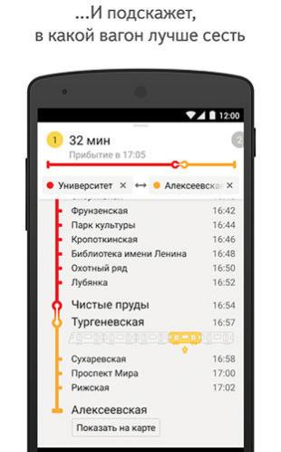
Yandex. Metro - is a useful application for those who often goes by subway. The application will make exact calculation of time, offer the best route and give the switch points. Select the destination and departure stations according to the scheme and easily plan your subway trips.
Game features:
Time calculation including switch points
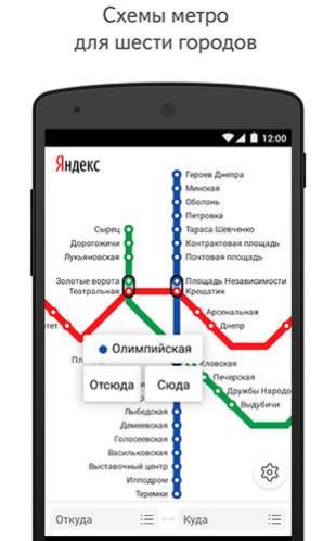
Up-to-date schemes
Work in offline mode
Scheme for each route
Loading video...
Like it? Share with your friends!
Supported operating systems:
Google Android 10.x, Google Android 4.0, Google Android 4.1, Google Android 4.2, Google Android 4.3, Google Android 4.4, Google Android 5.x, Google Android 6.x, Google Android 7.x, Google Android 8.x, Google Android 9.x
Similar Software:
amAze (LG) AmAze is a first of its kind free navigation and local search service. It is free to download and use and it contains wide coverage of maps including aerial photo in Europe, North America, Australia and parts of Asia and Africa
World Map 2011 FREE World Map 2011 FREE - World Map
*** NEW RELEASE ***
View a large quick reference World Map on your Android today!
Contains Up-To-Date World Maps!
Did you know?
-------------
South Sudan became the world's 195th country following separation from Sudan on 9 July 2011
Features
---------
- Political World Map
- No internet connection is required
Street View on Google Maps Street View on Google Maps - New! Street View smart navigation -- move around by dragging "Pegman" where you want to go. Try Street View on Google Maps to view street-level imagery from your phone. To use Street View, open Google Maps, search for a place or long-press the map, and tap the Street View option
OSMTracker for Android OSMTracker stands for OpenStreetMap Tracker. It allows you to track your journey and mark significant way points. Way points can be marked with a tag using a button, with a quick voice record, a text note or by taking a picture. The various button pages and layouts can be customized to suit your OpenStreetMap activities
OpenStreetMapViewer OpenStreetMapViewer provides Tools / Views to interact with OpenStreetMap-Data
Navigator Navigator - detailed maps with the support of satellite navigation. You need to specify two points to make a route. You can track your current location and set those coordinates as the route start. Thanks to marks on the map you can easily find a fuel station, restaurant or hotel
GoPenS GoPenS is an OpenSource GPS application for Android phones, based on OpenStreetMap (OSM). OpenStreetMap is a collaborative map of the world. Therefore, one of the main functions of the application is to be able to record a trace and send it as a GPX to the OSM servers, and so edit the OSM Map
Mobilex GPS Logger Mobilex GPS Logger - Overview ========================== The Android GPS Logger application captures GPS updates, and saves latitude and longitude coordinate fixes to text files on micro SD card. Supported Features inlcude: ============================== Google Maps. Satellite, Traffic and Street Views
amAze (Sony Ericsson) AmAze is a first of its kind free navigation and local search service. It is free to download and use and it contains wide coverage of maps including aerial photo in Europe, North America, Australia and parts of Asia and Africa
AugSatNav Walk AugSatNav is an augmented reality navigation system which overlays walking directions upon a live video feed of the path or road ahead.
With AugSatNav there is no need to follow instructions or interpret maps - you can simply find your way by walking along the route highlighted by a bright white line
Comments on Yandex. Metro:
Comments not found
If you noted an error or download link is broken, please, report it via this page or use comments.
Yandex. Metro is compatible with your device Asus ZenFone 5Z 2018 Global Dual SIM TD-LTE Version A ZS620KL 256GB


")


")
