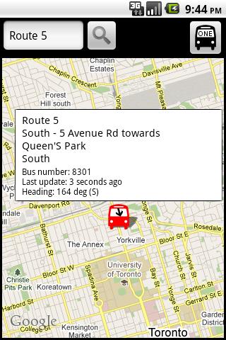
TorontoBusMap - TorontoBusMap shows locations and predicts bus times in Toronto using GPS info from the Toronto Transit Commission.
What's New in This Release:
· GPS now turns on when you start the app to allow quicker location lookup times. NOTE: There is also a new checkbox in the settings to disable this if you do not want it
· all stops mode added! This will show and update all bus stops around the center of the screen, not just ones on your current route. May be slow for older phones
· recently updated stops are temporarily colored green to show that they've updated
· search now searches stop titles in addition to routes
Like it? Share with your friends!
Supported operating systems:
Google Android 1.5, Google Android 1.6, Google Android 10.x, Google Android 2.0, Google Android 2.1, Google Android 2.2, Google Android 2.3, Google Android 3.0, Google Android 3.1, Google Android 3.2, Google Android 4.0, Google Android 4.1, Google Android 4.2, Google Android 4.3, Google Android 4.4, Google Android 5.x, Google Android 6.x, Google Android 7.x, Google Android 8.x, Google Android 9.x
Similar Software:
Airport Info Lite Airport Info Lite provides realtime airport status information (for USA only currently), including closures and weather delays.
Includes a widget for home screen rotating info on problem airports, as well as application for detailed viewing of individual airports
Travel VisaHQ Widget - Firefox Addon Travel VisaHQ Widget is a unique application for checking visa requirements and search embassies.
The addon will help in planning your trip. In a few seconds you can find out whether you need a visa to the country you want to visit and learn the address of your embassy
BeTrains - SNCB Belgium BeTrains - SNCB Belgium - Timetable for the SNCB / NMBS, the train company in Belgium
* Timetable in Real time
* Route planner between 2 cities
* All the belgian Stations on GMaps
* Leave message for other train users and read what people in your train are talking about, meet people!
* Get a Twitter Livefeed of all the current traffic issues
Store Hours Store Hours by HourDB is a store hours look up service for the US. It currently indexes around 320,000+ locations, which are easily searchable. So, ever wonder when the restaurant chain by your house closes? Finally you can find out. Or, if you want to find all the open locations around you at 3AM -- you can do it
Sydney Metro This app grants you fast acces to the last Sydney metro map, no internet connection needed once it has been installed. Full zoom controls. Fast, light and simple
phoneHotel With phoneHotel from probasys it is easy to look for a hotel in the area of your travel destination or if you have GPS in your smartphone, in a given radius of your actual location. You get the hotel room rates and all other information available. You can choose a hotel and book it with a few clicks online from your mobile
Delhi Metro Information Delhi Metro Information - Delhi Metro Information gives you all the information about Delhi Metro.
You can easily find any route direction, parking available on station,fare between two stations and many more.
Just download this application FREE and get all the information about Delhi Metro
DC Metro Transit - Free Realtime predictions for Washington DC MetroRail, MetroBus and other local buses Free (with ads) mobile interface for WMATA: -Tablet friendly layout (Honeycomb Compatibility) -Real-time predictions: DC Metrorail, Metro Bus, Circulator, PG County-The Bus, Fairfax CUE, UMD Shuttle
Offi - Public Transport Buddy Everything you need for mastering public transportation! • departure times (live, including delays), • nearby stations (also on a map), • direction queries and
Other Software by developer «George Schneeloch»:
Los AngelBus Los AngelBus - This application shows locations and predicts bus times in Los Angeles using GPS info from the Los Angeles Metro.
What's New in This Release:
· GPS now turns on when you start the app to allow quicker location lookup times
UMichBusMap An Android application which shows the live positions of University of Michigan buses overlayed on Google Maps
BostonBusMap BostonBusMap is an application for Android phones. It uses GPS data provided by the MBTA to plot the real-time location of buses on a map.
What's New in This Release:
· GPS now turns on when you start the app to allow quicker location lookup times