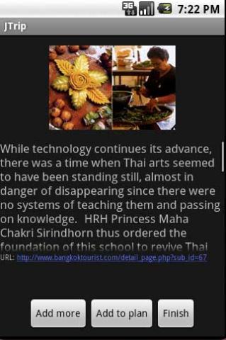
JTrip - Create your own trip in Thailand. JTrip recommends attractions and directions that you need. Let's get to know Thailand together.
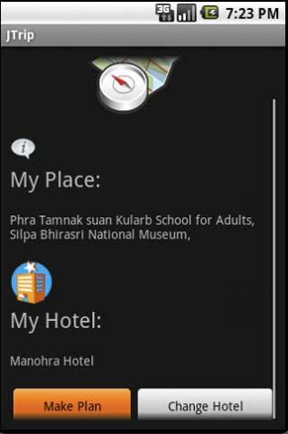
· select places.
· select hotel.
· show map location.
· route path form src to dest.
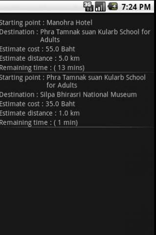
· taxi, time remaining.
· suggest bus number.
· suggest mrt/bts stations with gps current location.
· open facebook.
Like it? Share with your friends!
Supported operating systems:
Google Android 1.0, Google Android 1.5, Google Android 1.6, Google Android 10.x, Google Android 2.0, Google Android 2.1, Google Android 2.2, Google Android 2.3, Google Android 3.0, Google Android 3.1, Google Android 3.2, Google Android 4.0, Google Android 4.1, Google Android 4.2, Google Android 4.3, Google Android 4.4, Google Android 5.x, Google Android 6.x, Google Android 7.x, Google Android 8.x, Google Android 9.x
Similar Software:
EV Speedo EV Speedo is a GPS based speedometer with gadgets to provide g-force and other GPS information.
A built in map is also provided and any of the gauges provided can be overlayed upon the map, for example use the map to show your location with a speedometer to show your current speed
amAze (LG) AmAze is a first of its kind free navigation and local search service. It is free to download and use and it contains wide coverage of maps including aerial photo in Europe, North America, Australia and parts of Asia and Africa
Mobilex GPS Logger Mobilex GPS Logger - Overview ========================== The Android GPS Logger application captures GPS updates, and saves latitude and longitude coordinate fixes to text files on micro SD card. Supported Features inlcude: ============================== Google Maps. Satellite, Traffic and Street Views
Hunting the Snark Hunting the Snark - Inspired by Lewis Carrol's poem, The Hunting of the Snark, Hunting the Snark is an action game played on both your GPS-enabled Android device and in the real world. In it, you hunt a Snark (the creature on the map in blue.) If you invade its physical location before the game time has expired, you win. Otherwise, you lose
yozi yozi is a navigation software for the Android platform. It uses digital topographic maps in well-known Ozi Explorer formats for navigation and doesn't require network access like built-in Maps application on Android
Maps In My Pocket (MIMP) Maps In My Pocket - The main goal of this application is to allow its users to view maps, locate themselves, follow KML or GPX formatted tracks and getting directions from place to place.
What's New in This Release:
· New Icon
What's New in 1.4.3:
· Long press and long pinch concurrency on info bubble solved
Speedometer GPS Speedometer GPS - Speedometer GPS can track your speed,distance,time,location and also can get start time,time elapased,avg speed,max speed,altitude...
Features included
- Save your track info,Record gpx file(it will be saved in "sdcard/SpeedometerGPS/gpx/")..
- Switch between car speedometer and bike cyclometer.
- Switch between mph or km/h mode
MapMe MapMe allows mobile users to locate their position via GPS. If the users move beyond specific range or distance, the application will automatically display the location on a map
AugSatNav Walk AugSatNav is an augmented reality navigation system which overlays walking directions upon a live video feed of the path or road ahead.
With AugSatNav there is no need to follow instructions or interpret maps - you can simply find your way by walking along the route highlighted by a bright white line
Place Nearby Place Nearby - This application is all about searching for a desire location on map anytime, anywhere or anyplace.
This application just required a high speed internet connection, Network / GPS enabled device to search for your desire location.
This application will show you the live traffic near by your present location
Other Software by developer «Annop Kobkij»:
not found
Comments on JTrip:
Comments not found
If you noted an error or download link is broken, please, report it via this page or use comments.
JTrip is compatible with your device Asus ZenFone V Live LTE V500KL


")


")


