Map Locate Ad - This app is not created to replace Google Maps or other feature rich mapping apps. What this app does is to serve a simple need for certain group of users. Use case is you own jpg,png image files of tradeshow,house,store,apartment,garden etc floorplan and you want to draw pins on different location within the floorplan. Upon tap the pin you want to store some information for that location. So from user perspective, you see the floorplan with pins on them.
App works by assuming the jpg,png floorplan image files are split into many squares along X and Y axis. Each square is then where the app will draw pin in them.
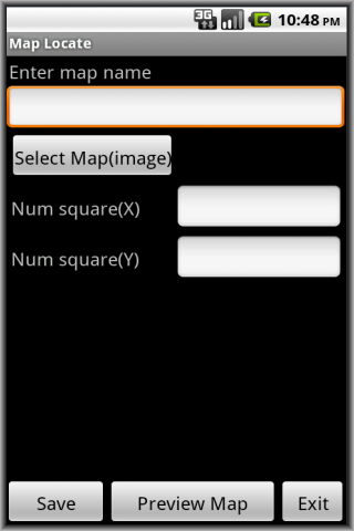
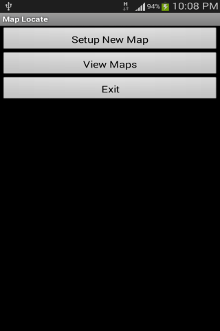
To use, tap Setup New Map. Give a map name, tap Select Map(image) to bring in your jpg,png image file from Gallery. Give a value for number of squares for X and Y axis. Tap Preview Map to preview and notice app take origin (0,0) as bottom left corner. Tap Save to save the map.
Then go to tap View Maps. Tap Edit to change the number of squares for X and Y axis (if you wish). Tap View to see your map. This is where you start to add pins to the map. At the top, specify the X,Y value then tap Add Pin. Pin appear on map. Tap on that pin and a pop-up appear. Add your own location specific information and tap Save. Pinch to zoom in is supported. This help you to see the pin and surrounding close-up. To get back to original, tap the 1:1 button on top. Tap the Grid button to toggle grid on and off.
Important points to note:
- Since most floorplan images are huge, try to scale the image in advance to dimension close to the smart-phone screen size. This ensure when the app render the image it is close to original and your pins drawn on top will look nice.
The application support English, Simplified Chinese, Traditional Chinese display.
Like it? Share with your friends!
Supported operating systems:
Google Android 10.x, Google Android 2.3, Google Android 3.0, Google Android 3.1, Google Android 3.2, Google Android 4.0, Google Android 4.1, Google Android 4.2, Google Android 4.3, Google Android 4.4, Google Android 5.x, Google Android 6.x, Google Android 7.x, Google Android 8.x, Google Android 9.x
Similar Software:
Waze Waze is a free, 100% user-generated, social navigation application that allows drivers to build and use live maps & real-time traffic updates to improve their daily commute
Osmand: Maps and Navigation Osmand: Maps and Navigation - is a navigation utility. Support of electronic maps gives you a chance to get new updates all the time. The map has marks which will help tourists. Embedded satellite navigation allows you to make the shortest route fast
Metro LX Metro LX is a comprehensive guide to the Lisbon Subway providing:
A map of Lisbon Metro (subway) in landscape and portrait modes;
A route planner between stations;
A map route to station from your position;
And detailed information per Station.
What's New in This Release:
· Updated tariff (February 2012);
· Minor bugs fixed on tablets
ViewRanger GPS ViewRanger is a unique mapping, navigation, tracking, and information tool for mobile phones that provides fully featured outdoor gps and trail navigation through a natural and intuitive display. ViewRanger transforms a Nokia or other Symbian S60 smartphone into a fully featured trail navigation system
GoPenS GoPenS is an OpenSource GPS application for Android phones, based on OpenStreetMap (OSM). OpenStreetMap is a collaborative map of the world. Therefore, one of the main functions of the application is to be able to record a trace and send it as a GPX to the OSM servers, and so edit the OSM Map
Barcelona DK Eyewitness Top 10 Travel Guide & Map (BlackBerry) Barcelona DK Eyewitness Top 10 Travel Guide & Map (BlackBerry)- -From Gaudi''s mind-boggling buildings to the Gothic Quarter, your holiday to Barcelona starts the moment you open the guide, plus Barcelona maps and metro maps
OS Map OS Map is a tool to turn your Android phone into a handy Ordnance Survey map, with your GPS position pinpointed on it!
· Nearly all OS Map scales available (including 250,000 and 50,000).
· Touch-scrolling - simply use your finger to drag the map around.
· Fast resume from standby and fast position updates
Map Navigation Map Navigation - detailed maps of cities and countries. Use this application in any place of the world without Internet connection. All data is updated all the time and boots in no time. You can make marks on the maps and send them via e-mail
Navigator Navigator - detailed maps with the support of satellite navigation. You need to specify two points to make a route. You can track your current location and set those coordinates as the route start. Thanks to marks on the map you can easily find a fuel station, restaurant or hotel
AugSatNav Walk AugSatNav is an augmented reality navigation system which overlays walking directions upon a live video feed of the path or road ahead.
With AugSatNav there is no need to follow instructions or interpret maps - you can simply find your way by walking along the route highlighted by a bright white line
Other Software by developer «Sohguanh»:
Migraine Pic Ad Migraine Pic Ad - Migraine sufferers usually have extensive note taking whenever migraine strike so that they can bring them to their doctors for discussion and trying to find the reason why it strike them. This app does not aim to do that. What this app is to complement the note taking process
Network Alert Ad Have you come across a situation say while your smart-phone is on Wifi and then you move around your house, it sometimes switch to other Wifi network? Ideally you want to be informed for the new network connected
Checklist Planner Ad Checklist Planner Ad - In our daily lives, very often we uses something that resemble a checklist. Example for every grocery trip, there are some items like rice,bread etc that is a must-buy. For every trip overseas, there are some items like change money, tourist map etc. For every cooking, there are some items like sugar,salt,pepper,onions etc
Last Call Ad Are you in insurance, property or other agent line of work? Very often when prospective customer call you on your smart-phone, you want to see the most recent call entries from that customer before you answer the call
StatusBarAppsAd StatusBarAppsAd - Have you run out of Home screens space to host your commonly used application icons? This app provide an alternative. It make use of the Notification status bar to host application icons. All you got to do is pull down, select your application and tap. This is useful when say you are inside an app and suddenly you want to launch another app
JMX Flashcard Ad This is a flash card app to teach young kids new words/things. Only twist is the flash card is constructed based on your own pictures stored in Gallery and the audio accompanying the flash card is your own voice recording
One Launch Many Ad One Launch Many Ad - For users who have a habit to launch certain default set of apps (e.g messaging,browser,email etc) every-time they screen on, this app is to serve that need.
To configure, tap New Task, enter a task description, tap Select Applications to add those apps you always want to launch them together. Check the Launch from widget checkbox. Tap Save
Whose Turn Ad Whose Turn Ad - Very often in our daily lives, we have daily tasks that are turn based. E.g washing of toilet is to be rotated between you and your spouse. Moping of floor take turns. Wash dishes take turns. Who to take bath first, queue up etc is to be rotated between your kids and many more tasks are turn based
Batch Image Resizer Ad Batch Image Resizer Ad - For some people who has a need to resize images in batches of many, this app is to serve the need.
To configure, set the input folder (at least one), image resize width and height, output folder (one). Tap Execute Rule to start resizing those images fulfilling the criteria or tap Save Rule to save the configuration to be re-used later
Check Contacts Ad This app provides a simple search screen for your Contacts. It allow you to search by contact partial name,email address,company name. To search all contacts, just leave the Partial Name,Email Address,Company Name fields empty and tap Search


")


