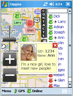
Gippos is an application for mobile devices allowing the user to locate his or her position on the map, share the location with friends and see other users on the same map. Users can also exchange instant messages with their friends.
You will need a GPS receiver for locating yourself on the map and the Internet connection for locating other users and exchanging messages with them.
Currently Gippos supports GoogleMaps and Microsoft maps. The maps are cached and the cached sections can be viewed offline.
You can hide your location if you don''t want other users to see you on the map. You can also see a Gippos user on the map at www.gippos.com if the user didn''t hide his location.
Currently Gippos is compatible with Windows Mobile 5.0/6.0, soon Gippos for iPhone and for PC (win32) will be released.
If you got an error while installing Themes, Software or Games, please, read FAQ.
Supported operating systems:
Windows Mobile 5.0, Windows Mobile 6 Classic, Windows Mobile 6 Professional, Windows Mobile 6.1 Classic, Windows Mobile 6.1 Professional, Windows Mobile 6.5 Professional
Similar Software:
GPSAltimeterer GPSAltimeterer uses the GPS on your PocketPC to find your altitude. You can view in Meters or Feet. This can be used on a plane that does not allow full GPS. Start the program to find your height via GPS on it. NOTE: Make sure you are allowed to use this program before starting the application
MapSpeedometer MapSpeedometer - MapSpeedometer uses the GPS on your PocketPC to measure your speed in Km/h and says it in a computerized voice at a selectable interval. The program displays your speed in Km/h and reads it at a customizable interval rate.
This program requires that you have both the 'BeanDLL.dll' file ** and ** the runtime files for Visual Basic on your PocketPC computer
CellGPSer CellGPSer uses the cellular signal on your device to instantly find your approximate GPS. Tap the button while your phone is on and the program will send your cellular tower information to OpencCellID.org. The program will then display the approximate GPS. This service is provided by OpenCellID
FoodGoogling FoodGoogling uses the GPS on your PocketPC to find the top 50 closest local food shops sorted via GPS distance. Select the food type and tap the button to start the GPS and when you get a lock tap on it to view the list selected type of local food shops. The GPS maps and business search service is provided by Google
Smartphone Tracker Smartphone Tracker - allows you to locate your phone via GPS coordinates, useful if your phone gets lost or stolen, and for locating missing family members. Basically, SmartPhone Tracker is configured to listen for a certain text message. When it receives that text message, the program will wake up, activate the phone’s GPS and obtain a lock
DrinkGoogler DrinkGoogler uses the GPS on your PocketPC to find the 50 closest local bars sorted via GPS distance. Tap the button to start the GPS and when you get a lock tap on it to view the list of local bars. You can also dial the bar. The GPS maps and business search service is provided by Google
BackCountry Navigator BackCountry Navigator is fun-filled navigation software for the outdoor adventurer. Use it in a variety of outdoor adventures, from kayak touring to geocaching. This is a summary of what you can do with the product.
BackCountry uses free topo and aerial maps for the United States, downloaded directly from Terraserver-USA
PictureGPS PictureGPS allows you to tag pictures from your PocketPC camera in real time with a GPS stamp and view the distance of each picture via your current GPS. You can use the ruler to view the distance of each picture and also view the GPS stats for each picture with a Google.com map. The map service is provided by Google
GPS Speedometer GPS Speedometer is an attractive speed meter on the car dash for Windows Mobile phones.
Make sure you have .net framework installed. The setings.exe included in the attachment is from the Microsoft SDK samples, which can be used to set the COM port if you dont' have any other application.
This has been tested in HTC P3300 (Artemis) and HTC TyTN
FON Access Points for Costa Rica FON Access Points for Costa Rica - FON offers you a new Points of Interest service (POIs). This allows you to download FONspots directly to your navigation device.
What does that mean? You can download a Points of Interest file directly to your navigation device
Other Software by developer «Versane LLC»:
not found
Comments on Gippos:
Comments not found
If you noted an error or download link is broken, please, report it via this page or use comments.
Gippos is compatible with your device AT&T Fuze (HTC Raphael 101)

")