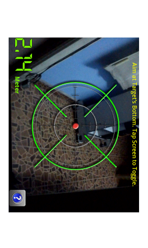
Distance Measurement - Quick distance calculator, measurement or estimator using:- 1. Screen (for small object) 2. Camera (for short distance) 3. GPS/Network (for long distance) ~~~~~~~~~~~~~~~~~~~~~~~~~~~~~~ A) How to measure using Screen:- 1. Put the object on your phone's screen 2. Drag the button to start measurement B) How to measure distance using Camera:- 1. Hold up your phone in Landscape orientation and estimate the phone's distance from ground. 2. Then aim the camera at the bottom of the object and the app will do the calculation C) Measure distance using GPS/Network:- 1. Get the coordinates when you are at Location A. 2. Then move/walk/drive to Location B and get the second coordinates. 3. When you have the coordinates for both locations, the app will auto calculate the distance.
Like it? Share with your friends!
Supported operating systems:
Google Android 3.0, Google Android 3.1, Google Android 3.2, Google Android 4.0, Google Android 4.1, Google Android 4.2, Google Android 4.3, Google Android 4.4
Similar Software:
Point Where Ad This app does not aim to replace a compass. What it does is to serve a simple need using the accelerator and magnetic sensors in Android phone to point direction. For some people, you need to know the direction of a place/city reference to your own location
Advanced Compass Advanced Compass - You are backpacking as part of an impromptu adventure trip. You are kind of lost and need to know the correct and accurate direction.
You need to say your daily prayers and need to know the exact direction
GPS Odometer GPS Odometer - A simple and easy to use odometer. There is no maze of menus and no mysterious settings. GPS Odometer only does one thing, and does it well: measure distance traveled.
Note: Intended to measure relatively short distances, the application does not run in the background
Easy Compass Easy Compass - Easy Compass is a sensor compass for android devices ,with two different designs
Sun Moon Dial Sun Moon Dial - A Sun and Moon Compass dial. A fun visual app to show off the compass feature of the g1.
Before your Comment - THIS IS A DEMO app -- just wanted to show something that the iphone couldn't do. This app has no purpose - it was written in about an hour (plus a couple to make the kiddie graphics)
GeoLog GeoLog saves the sensors data (gps, accelerometer, magnetometer data, etc.) of your device to a log file and calculates the coverage of the site. The coverage is a ratio of the track covering area to the area of the site (expressed in percents)


")


